
The 220 km Larapinta Trail is a bit of a con….
________________
It’s a funny thing, despite the Larapinta Trail being regarded as something of a toughie, just about any one I mentioned it to had either done it, or done part of it. Officially, it runs for 220 km along the MacDonnell Ranges, to the west of Alice Springs – in other words, more or less in the dead center of Australia. It’s dry, typically rocky, and in summer, very hot. The ideal time to walk is in mid winter, when day time temperatures can still get hot, but the nights can be freezing.
Why do it? Well, it’s a part of Australia that I’ve had no experience with and I wanted to get some sort of understanding for. Before I started I would also have said that doing such a hike is a kind of ‘boy-thing’. It’s nice to be able to prove to yourself every now and then that you’re capable. However, as I and others I met would learn, there are more solo female trekkers on the Larapinta than men (I did consider an alternative blog title of “Walk the Larapinta and meet women”).
A typical time to walk the trail is said to be about 13-15 days. Although some take 20, it has been done in 8 (some run it in less), but many walkers arrange for food-drops along the way. So there are various ‘models’ to walk the trail. I preferred not to bother with food-drops, but to carry it all, and do it in few enough days that I didn’t have to carry much. It wasn’t an issue of travelling fast, just putting in long days. This is defined as walking the Larapinta ‘unsupported’, although this is a bit of a fib. In reality, a major logistical constraint is water. National Parks truck in water to a series of tanks along the trail. Natural occurrences of water, at least in winter, are very few and far between, and as I would find out, fairly unsavoury. I doubt it would be possible to walk the Larapinta genuinely unsupported (although surely some maniac will try). I figured on ten days of food, with some extra ‘just in case’.
Minimising weight was the big issue. I’m happy to sleep under the stars in just my sleeping bag. But I obsessed a bit about rain. Winter is the dry season in central Australia, when it doesn’t rain. Except when it does. My chain of thought cycled through my two-person tent, tent fly only, tarp, poncho tarp, small tent, before finally deciding to take just a bivvy bag.
Being unsure of how long it would take meant that the obvious way to walk was from the far west end at Redbank Gorge, back to the town of Alice Springs in the east. Buy how to get to the western end? Various companies offer the service – but for several hundred dollars. Now I know business is business, but that’s a big ‘ouch’ factor. I opted for a suggestion of paying less for a one-day commercial tour that stopped for lunch at Glen Helen resort. From there I could simply bail-out and then hitch the final 25 km to the start of the Larapinta at Redbank Gorge. It sounded like a good idea.
After an excellent guided tour (with Emu Run) and lunch, I stood at the entrance to Glen Helen for just a few minutes before deciding that was a bad plan. There was very little traffic coming from Redbank Gorge and even less going towards it. I figured that if I started walking, in the worst case scenario – I’d at least get there this side of midnight. Well, to cut a longish (and boring) story short, I walked more than 21 of the 25 km to the campsite. There was perhaps one vehicle going my way every half an hour, mostly at high speed, and no doubt ill-inclined to stop for a lone traveler. In the rapidly fading dusk, I was already on the gravel side road to the gorge when a lovely holidaying Swiss couple pulled up and offered me a lift.
Dark had fallen by the time I made it to the sandy bed of the river coming out of Redbank Gorge and began my nightly routine; lay out my foil space blanket, blow up my mattress, lay down my bivvy-bag, then toss my sleeping bag on top. Boil a cup of water to put into my dehydrated meal, some more for a soup, or instant potato, and another for a cup of tea. Before bed I stripped down to undies and put a T-shirt on, and took off my thick socks and replaced them with light ones.
That night, and each subsequent night, I would wriggle into my sleeping bag and, by chance, find myself staring up into the great Scorpion constellation. Jupiter would be high, and Mars lying low to the east. I watched satellites (ones that start bright and gradually fade as they lose the sun, and those that flash as they rotate) and meteors (those that arc dramatically and those that end in a fluttering fish-tail) and jets on the night-haul up to places like Singapore and Bangkok. However, in those first nights, the moon was full in the early evening, and going to bed under full magnificence of the Milky Way was still a few nights off.
It’s just me, but I don’t sleep much, if at all, when I camp. Instead I doze and fall into the odd dream phase. In the wee hours of that night something made me stick my head up – for a surreal and briefly disorientating sight. The entire width of the dry river bed, just a few meters from me – was a chain of little lights. It took a moment to realise it was about twenty people with their head-lamps on, departing for a sunrise tour of Mount Sonder. I put my head back down, until about ten minutes later, another group of about 20 came past. Then a small noisy group walked past, then whoever was occupying the tents up river from me – pointing their head torches at my face as they passed by. Getting up at four in the morning to climb Mount Bloody Sonder to see the sunrise is not really my thing, especially with 50 others, so I put my head back down and waited for dawn.
On the Larapinta, dawn turns to sunrise gradually, so, so gradually. At first it’s hard to tell if the slight glow on the horizon really has anything to do with the sun. Even when it’s become clear, it’s still ages before it gets light enough to make a move. Then at last the sun would make its appearance somewhere between Orion (the Scorpion’s prey) and the Seven-Sisters, and the near-freezing night temperatures would rocket to the twenties or even thirties.
When it got light enough to get up, I saw where I was. Scattered River Red Gums that had had a very hard life grew along the dry river bed. Not only do they have to survive fire and drought, when they self-amputate limbs to hunker-down (Australians know not to camp directly below their branches) but they get smashed up by debris in every flash flood. The most gnarled of these made wonderful photographic subjects – except my hands were so damned cold, I had to keep putting them in my pockets to keep them functional. Worse, the miserable cold of that camp site affected something else – the ignition clicker of my JetBoil gas cooker loses its clickiness. No warming cup of tea as I sat on a rock and ate my cold muesli.
The turn off to climb Mount Sonder was just a couple of hundred meters past the river. I ignored it, and walked on a couple of kilometers before a kind of accumulated peer pressure to “do Mt Sonder” finally got the better of me. So I hid my pack, walked back, and headed up the mountain. On this track I got my first experience of what underlies much of the Larapinta. Quartzite. Lots and lots of hard quartzite (it goes ‘clink’ if you knock two bits together), typically occurring as ankle-breaking, softball size boulders all along the trail.
Maybe a third of the way up I decided enough was enough. The view was great, but I was pretty sure there would be plenty more of those to come. I wanted to get to Finke River that night- and I was cutting it fine. Finke River, reputed to be the oldest in Australia, still lay 24 km off.
Along the lower slopes of the ranges and lowland themselves, the vegetation is a low forest of ‘malle’ – multi-stemmed eucalypt trees, mulga acacia, and patches of prickly spinifex grass. Going up one incline I pulled over in the shade of one small tree for a short break. I had some munchies, and took a GPS reading. Then I headed on, marvelling at what seemed like piles of rusty iron beside the track. These were outcrops of laterite – the ancient deeply weathered Australian crust.
Arriving at Rocky Bar Gap (I didn’t see any bar) a weird impulse sent me to check the route with my GPS. With growing horror, I realised it wasn’t in my pack. This likely meant it was lying by the track, way back where I had taken a break and used it last. I dumped my pack and almost ran back. I knew it was under some malle on an up-hill stretch and was fairly sure I would know the spot. As I came over the likely ridge, two crows fled the track in front of me. They had found my GPS, had dragged it onto the middle of the track and were giving it Hell, but no damage done. Damn it! I had come three kilometers back – a six kilometre diversion that cost me an hour.

River Red Gums in the bed of the Finke River.
The track now went through the gap to the north side of the range, then turned back and rose steeply about 300 m to the range top, then back down to the south side. That out of the way, the trail then headed over easy-going, rolling lowlands, towards the Finke.
The Larapinta is a generally well-defined, narrow trail (usually one party has to give way and step aside when they meet another). It’s marked with plenty of blue triangles on posts, trees or rocks. Every kilometer these show the distance to the next main camp site. As I walked, these showed the distance to the Finke getting less and less, but so did the light. The sun set and there was, mirroring the dawn, a long dusk, but eventually I had to concede that it was night. My final hour and a half was walked under moonlight. It was full, and mostly the track showed up very well. Each low ridge I crested held the promise of seeing the Finke River below, but time and time again, the stars silhouetted one more ridge ahead. Finally following a slightly confusing muddle as the trail descended steeply below some tall trees, everything opened out, and I was trudging across a wide expanse of deep sand – the dry Finke River bed.
In the moonlight I saw the outline of a hut – and a couple of figures sitting at a table with their head-torches on. So as not to scare the be-Jesus out of them, I flicked my light on at a respectful distance and called out a “Hello”. They were a pair of young women who had walked from Alice, with just one more day to finish their trek. They had set up their tents on the raised pads within the shelter, but showed me where the nearest camp spot was. They soon retired, and I did my cooking on the table.
The night was cold, but nothing like the river bed of the previous night. In the wee hours before dawn I reached out and grabbed the burner part of my gas cooker – the bit with the ignition clicker, and put it in the sleeping bag with me. When I got up – the clicker worked, it’s just that the gas wouldn’t ignite… Once again no morning cuppa for me. But the two young women said that Ormiston Gorge, with its cafe, was only a couple of hours walk away.
In Ormiston I reduced weight by getting rid of some food – a bag of muesli and my heavy cheese slices. I felt bad about that, but at this stage I hadn’t had the chance to really look at the camp shelters, and didn’t realise that the big Aboriginal paintings at the back of them were not just Art in Public Places – but cupboard doors, where one could leave stuff that might be useful for other hikers. I cleaned up my feet and put Leucoplast over any signs of rubbing, then headed for a latte.

The Larapinta Trail over level country out of Ormiston.
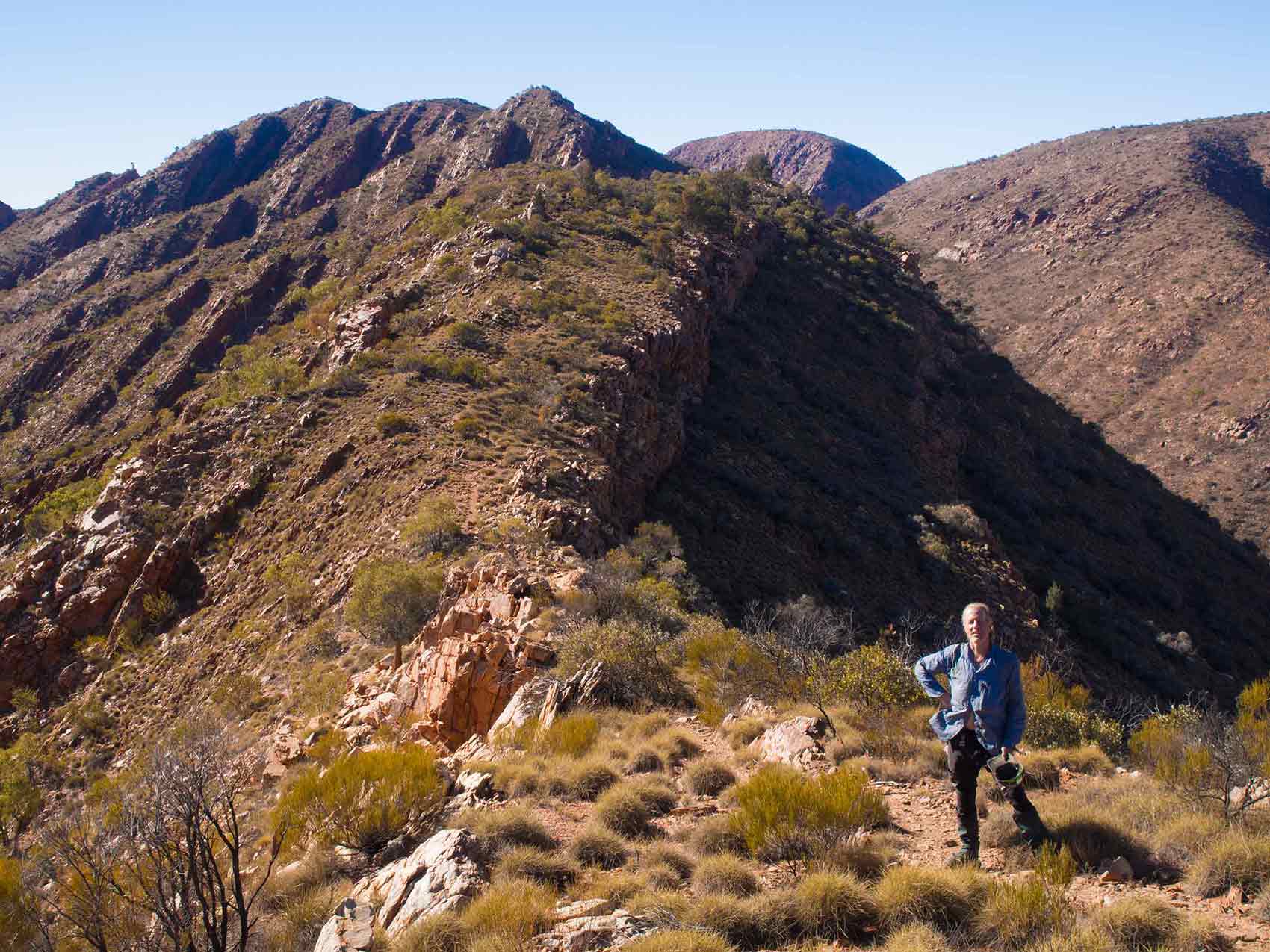
From Ormiston the track follows the base of the Hevitree Range for a few kilometres, before turning abruptly, to climb more than 200 m to the top. Somewhere on the way up, I felt a blister under my left foot burst. It must have developed on that quick up and over from Rocky Bar Gap the day before. I hadn’t had one under a foot for years. But apart from feeling a kind of ‘squeltch-squeltch’, it didn’t hurt. The track then headed off along the ridge-top. It was here, with miles and miles of Australia stretching out on either side, that I could get a clear view of the landscape.

Starting to climb up the Hevitree Range.
In the Aboriginal world-view, all landscape features were formed by ancestral beings in the Dreamtime. On that day tour that got me to Glen Helen, our guide, Cara, nicely explained the Aboriginal dreaming significance of the MacDonnell Ranges. For the traditional owners, the Arrernte people, the mountain ranges are the bodies of dream-time caterpillars. Specifically, they are a kind of itchy, hairy caterpillar that sometimes get it into their heads to migrate en mass to someplace else. I was amazed to see this once near my house in Brisbane. Walking down the street early in the morning I was astonished to see hundreds and hundreds of caterpillars, in many lines, over several meters wide, head to tail, moving across the road. Cars soon came out and the procession was soon squished over the asphalt.
In the central Australian dream-time a procession of such caterpillars traveled into the territory of a beetle, and rudely refused to ask permission to cross. A fight ensued, which the caterpillars lost – their bodies being nipped into lengths by the deadly beetle pincers. This is the simple, children’s-level dreaming story. It gives a clear basic lesson – if you want to cross into another tribe’s territory, stop and ask permission, or the outcome is likely to be bad. The story also imparts a basic geography for children to start developing their mental map of the world – the MacDonnells are elongate, like caterpillar chains and they are rent through by deep chasms. There will be more and more detailed versions of the story, but available only to the initiated. They will include other bits of lore, perhaps explaining those parts of the mountains where only men can go, or only women. Or perhaps – where no one should go at all.
On top of the ridge, I set up camp in the lee of the rocks which formed the highest point. They made a good seat to sit on and sun my feet while my dinner cooked. There was just one another hiker at the camp spot – Daniel, an American lawyer. He wandered over and after we started chatting, asked a silly question:
“Would you like some whiskey?”
Daniel was a veteran trekker. He had trekked in New Zealand, which he thought had “too many f@#king trees!” He also argued that two meals a day were sufficient while trekking. This was pretty much the conclusion I had come too. Mostly I never really felt hungry while I was walking, all that lunch and extra snacks was just more dead weight. That night the north east wind picked up, and the low trees above me thrashed around. There was even some light cloud cover, but it was warm.
But I took no chances with my cooker. In the wee hours of the night I hauled the whole thing into my sleeping bag. I got up before the sun rise, but Daniel had already gone – thus thwarting my plan to foist a pile of muesli, soup and instant potato off on him. The attention I paid to my gas cooker paid off – the clicker worked and the gas ignited. Water boiled, was added to a tea bag, milk powder and some turmeric – finally some luxury!
The next day the trail dropped off the range, and down to a much-needed water tank at Serpentine Chalet. By this stage I had seen lots of evidence of very-recent track work on the range slopes. Someone had put in a huge amount of work, not just physical, but highly skilled stone-masonry. I never saw them, but I doff my hat to them all. Their efforts were hugely appreciated.
From there I headed off to the base of the range again. A hiker who passed me going west enthusiastically told me about what was probably the “best view on the Larapintas”. He suggested I didn’t stop and camp immediately I got to the top of the range, but to turn left (west) and after a few hundred meters, I would get to Counts Point. There was a nice gentle incline to start, but then a solid plod up 200 m higher to the top of the range. Once there, I cached a bottle of water under a decent pile of rocks, then headed along to Counts Point. There was no-one there, which was a good thing, as the carefully-cleared camp spot was only big enough for one tent. I spent the last hour before sunset airing my feet and having a relaxed dinner. The hint was correct – the view along the ranges was spectacular.

The view from Counts Point on the Larapinta Trail.
At Serpentine Gorge I hid my pack by the trail and walked along the side track, firstly to see the pool of water in the gorge itself, then to climb above it for the spectacular view from a lookout. Retrieving my pack, I walked another 12 km and passed through a very crowded Ellery Creek campsite. From there the route eastwards gradually began to rise towards a gap in the ranges. The Larapinta contoured through the gap until in front of me was the Alice Valley – a broad expanse of low hills country bordered 9 km to the north by another range of the MacDonnells. I would get there tomorrow, but my more immediate goal was to find a place to camp before dark.

Heading across the Alice Valley.
Officially, on the Larapinta you can camp almost anywhere, but practically the options are severely limited. Mostly what lies on either side of that track is either clumps of spiny spinifex grass, big rocks, or small sharp rocks that will quickly tear a ground sheet or inflatable mattress to shreds. The camp sites are either carefully cleared patches the size of tents, built up wooden platforms – or the sandy beds of the dry river beds, down which the cold night air flows.
By now I had wised-up to dry river beds being soft, but frigid camp sites. But half an hour before sunset, when the trail crossed a river bed, I had no choice. I settled down to what I knew would be another cold night. As I made my dinner, three screeching black cockatoos landed in a distant tree. One of them peeled off to perch on a gum above me, and watched me quietly until the sunset, when it flew back to join its mates.
That night was bitter. If I stayed still, it seemed I lost round about the same heat that my body generated. But as I waited for the light, my feet got colder, and colder and colder. When I finally made the move to get up I found my plastic bottle of water was a slush of ice. What I found next was disturbing. The whole end of my sleeping bag was wet – and encrusted with ice. No bloody wonder my feet were cold! The bivvy bag had trapped perspiration, which had then froze. In a weird way, it was good news. It could be avoided by not using my bivy bag (unless it rained) and I could dry my sleeping bag out as I walked – and reduce its weight.
The rolling country of the valley continued as I neared the northern side. Somewhere out there, the Back-To-Alice fantasies kicked-in. A wash of course, for me and my clothes. Then pop in to the fabulous Red Kangaroo Bookshop and pick up a copy of Peter Latz’s ‘The Flaming Desert’. Then, early next morning (they open at 0730) ensconce my self in the Wicked Kneads Cafe, and a) order their home made muesli, b) a latte and c) sit back with Latz’s book (Repeating step b as often as required).
At the camp site at the mouth of Hugh Gorge I got rid of still more food, and a roll of sports tape was eagerly claimed by a youngster with nasty blisters on her heels. From now on, breakfast would be a muesli bar, some trail mix would do for lunch, and I would have a decent feed in the evening. There was tough walking to come. I felt like bomber crews must have, limping back from Germany in 1944, three engines shot up and throwing everything out – machine guns, ammunition, signed photos of Mae West, just to keep airborne and not crash into the North Sea.
I headed into the gorge, just as a solo woman hiker came out, and said my path ahead involved a “fair amount of bush-bashing”. There were also several of the rare pools of water that remain on the Larapinta over the dry season. After reaching one, I carefully looked through the trees and listened for more solo female trekkers. With no signs of any, I stripped off and had a three and half second dip in the chilly waters. The other end of the gorge came sooner than expected and I set up camp in the sand for what I guessed would be another cold night.
The next morning I walked up to a pass, gently down a valley on the other side, then turned sharply up a spur, passing white-trunked ghost-gums hanging on in nearly impossible spots. Finally I was walking along the spine of a rugged, rocky ridge, before a steep descent into what I think was the toughest part of the whole walk – a boulder hop down the Spenser Gorge.

Ghost Gum in impossible spot!
But the day was still far from over. After a deceptively idyllic walk along a level track by a dry, river red gum filled channel, the track turned up again. I could see it ascending the mountain ahead in a series of switchbacks towards a prominent pass a couple of hundred meters higher. Several groups of walkers passed me on the way down, with some pausing to explain what awaited me. Although it somehow seemed right that the pass was the goal, that was actually where things got tough. One woman described what came next as “a right bastard”.
Reaching the pass, the trail dropped down into a low forest of cypress and cycads. On the other side I saw a ridge, which looked like a tough, although not too serious slog to get on to. But my brain was playing tricks on me. It was trying to ignore the rest of the mountain – Brinkley Bluff, towering more than 200 m further up out of the corner of my left eye. There was even a rock set up as a chair at the base where you could sit and gaze up and wonder where in heck a trail could even go.
Once I set off, it turned out that the face had lots and lots of short switch-backs and the trail gained altitude quickly. As a group of youngsters moved down towards me I thanked them for coming to carry me up. One of them shot back “Anything for a friend!” As they passed, another added that I hadn’t far to go now. Then, almost at the top, I heard voices, and looked up to see a silhouette of someone standing right in the path of the sun.
“Christ!” I managed to blurt out as I staggered on to the ridge-line. This met with general agreement from two guys, Mike and Charlie, who had arrived a bit before me and had already set up their tents. We watched the sun gradually set, with Mike remarking how utterly different the landscape in front of us was from New Zealand.

Sunset from Brinkley Bluff.
Next morning Mike and Charlie left early, and I gave then half an hour or so, before I headed off. Despite walking into the sun, there was a glorious view. Quarzite continued underfoot, but sometimes as spectacular fossil ripple marks. A young solo woman came from the east, and asked me if I could snap a photo of her with her mobile phone. She looked well kitted-out and very fit. I reached Standley Gorge cafe about eleven o’clock and had finished a latte, before Mike and Charlie spotted me and I joined them for some green tea. They pointed out that the solo trekker, who had asked me to photograph her had had a large knife hanging from her belt. As they set up camp, I dumped some rubbish, hid around the corner while I re-bandaged the blister on my foot, and headed on.

Can you see the Larapinta? Descending off the east end of Brinkley Bluff heading for Standley Gorge.
Now National Parks don’t recommend lattes, but rather suggest you carry six litres of water. I found three to be amply sufficient, and on the shorter (say 15 km stretches) between main camps, 1.5 litres to be enough. But mountain top camping was different. There are no water tanks on them. One needs to have enough water to cover the slog on the way up, a cup or two to cook a meal, a cup for a drink, another cup for breakfast, then enough to cover the next day’s walk down the mountain to the next tank. But talking about water, I did have a short-lived brain wave at some poinrt. Arriving at a main camp with a load of water meant wasted energy. So, in the interests of weight economy, why not drink the last of it, when you’re almost there – say about three kilometers out? And here lies a peculiar phenomenon of the Larapinta.
Some kilometres when you trek are easy, They drift by regularly, one every fifteen minutes or so. They result from walking along at a nice, steady clip of 4, 5, even 6 km per hour. But then there are kilometers that can take an hour and those are hard hours of much increased water loss, feet bashing, brutalised boot soles, and continuous concentration on where you place your feet. These are Larapinta kilometers. There were lots of those, but soon after having that silly thought about water – it dawned on me that the toughest of them tended to be the last two or three kilometers of the day. Time and time again, just when the Larapinta kilometer signs told me I was all but home and hosed, with ‘only’ three km to go, and – the going would get really tough. There’s a reason for that. Main camps are typically at the mouths of gorges. And at least the way I was doing the trail, this meant the final leg of the day was the length of the gorge. In the gorges you don’t walk along a trail so much as simply get pointed down them and make your own way. This can involve edging down between car-sized boulders, pack on back, bracing with all four limbs, and trying to judge when to let go and land on the next boulder. Hard yakka, and thirsty work.
The trail out of Standley is a series of steps, made from massive blocks, tens of kilos each, of natural rock, maneuvered into something reminiscent of Macchu Picchu. The physical effort, let alone skill, that went into building these, must have been phenomenal. I grunted over the ridges, but buoyed somehow by a sense of outright wonder and appreciation of the builders.

Rugged country out of Standley Gorge.
On this stretch, despite my rebandaging, the blister on my foot started to give me real trouble. From simply being tender and causing me to limp, it now gave searing bursts of pain, enough to make me yelp. On the third yelp, I pulled over. My boot and sock came off, bandaged peeled off, and I twisted my left foot up to have a good look. Aha – sand had got into the edges of the blister. With scissors I cut the big bit of skin along two edges and folded it back to get at the edges. Using cotton buds and water I scrubbed the sand out, folded the skin back, and Leucoplasted over it. It barely bothered me again.
Meanwhile, the trail got gentler and gentler, and soon I was just sauntering along the side of a river. I was ‘almost’ at Jay Creek, when, right on cue, the trail suddenly swerved up a ridge. When it came down again shortly after, the reason became clear. It wasn’t payback for the track getting too easy– but to get around Fish Hole pool. It’s an Aboriginal sacred site, where camping is not allowed, though apparently cows stomping and shitting through it are. Just sayin. Then the final kilometer along the dry river, and I pulled into the crowded Jay Creek campsite just as it became dark. I found a campsite that was a little above the dry river bed.
In the morning my choice of camp seemed to have paid-off – the neck of my water bottle was only partly constricted by ice. The walk on from Jay Creek was subdued. In fact, too subdued – I didn’t trust it at all. As I ambled along towards Simpsons Gap there was a background stress, conjured up by my brain expecting the next mountain, But it never happened, it was just a thoroughly relaxing trail. This was fortunate, as by now my frugal eating was probably catching up. I felt a bit like a small cc car – one of those that can build up a good pace on the level ground, but konk out quickly on the ups.
It dawned on me then that the Larapinta had been devised by two quite different minds. West of Jay Creek, it’s all kind of black-hat. The trail seems to have been planned on a map, as a kind of endurance test. “Let’s send them to the top of that mountain, along that ridge, let them find their own way down that gorge, and oh heck, they’ve had it far too easy for a few kilometres, let’s send them up that ridge over there – they definitely need a new view”. But to the east – it’s white hat. The trail meanders carefully through the country, so gently along the easiest route, that it seemed if a ditch was dug along side, water would flow from one end to the other. Perhaps that section of the track is the old Aboriginal trail between Simpsons Gap and the Fish Hole pool?
That afternoon was hot – I think more than 30 C. At Simpsons Gap a young solo female trekker was relaxing after getting in from Wallaby Gap, my goal for the day. There was mutual surprise as she said her night had been too warm to use a sleeping bag, while I mentioned getting up to ice in my water bottle. Such is the variety of the Larapinta.
A little after dusk had turned to night, I pulled into Wallaby Gap, guided by someone’s head lamp. There were several groups there, and as they retired, I sat on the shelter bench and heated up my last dinner. With the Scorpion once again overhead, a single mournful dingo call pierced the night, and, as the other trekker had said – it was warm.
The next morning a leggy solo female, with shorts and knee-length gaiters strode out of camp before the sunrise. I followed about half an hour later, soon able to recognise her boot prints amongst the dozens of others in the track, but never saw her. What I did see, just a few minutes out of camp, were two wallabies. They bounded off the track, and stopped to watch me pass. Other than birds and a few lizards, they were the only animals I saw on the whole trail. The trail rose onto a ridge, and in the distance were the buildings of Alice Springs. The trail descended, crossed the railway line, then the main road. Somewhere there a woman passed me saying she had recognised me several days earlier on the track – because “I was the only guy carrying an umbrella!” (I didn’t tell you that, did I? (: )
But then the trail began meandering through rolling shrubland and for a while it seemed like those black-hat minds had decided to string the trail out a bit more – surely I should have reached the closest buildings by now? And then I realised – the trail was being led masterfully past Alice suburbs. This meant that the old Alice Telegraph Station is almost the first structure one encounters in Alice. It’s a cafe now, and, surrounded by the standard mob of lycra-clad cyclists, I ordered a latte, a cheese toastie, and added to the pig-out with a chocolate brownie.
The backpackers where I had stored gear was only a couple of km further down the path. But my trip was not quite over. As I entered the backpackers, the managers face dropped.
“Ah, you came back too soon….” he said.
It was the first indication that I had barrelled the trail a bit quickly (I had lost track of the days – this was number nine). The backpackers was full (to the point that the TV room had three people in it). He suggested that I try the Information Center. I trudged there and a helpful woman made a series of phone calls, ending each one with a cheerful “No problem!” Eventually she let me know that I did in fact have a problem – there was no accommodation in Alice for less than $200 a night. Perhaps I could try the camping grounds? Well, thanks but no-thanks. Having slept on the ground for free for the last nine nights, why would I pay now? I messed around town (“recharged” was the word The Wicked Kneads Cafe used), then late in the afternoon, trudged a couple of km back out of town, and with no one to witness except a rock-wallaby, slipped off the trail onto a little patch of sand behind some scrub, and kipped down for the night.
So a 220 km Larapinta Trail? Let’s see, the 21 walk from Glen Helen was self-inflicted, as was leaving my GPS by the track. Walking up Mt Sonder is not officially part of the trail, but it’s almost expected that you do it. And as for the couple of km from the Telegraph Station into the center of Alice, you may as well walk that too, and not to mention the final walk out of town. Frankly, I think almost everyone would end up walking more than the ‘official’ length of the Larapinta. But in any case, those numbers are almost meaningless. My 37 km walk from Jay Creek to Wallaby Gap was one of the easiest, and yet a few kilometers down the boulders of Spenser Gorge took more out of me.
The thing about the Larapinta Trail is that many of its kilometres are not just kilometres – they are Larapinta kilometres.
5 comments
Certainly a special part of the world, the Larapinta didn’t exist when I passed through but I got hold of a push bike, went a bit out of Alice and climbed through the bluffs of an escarpment for the surprise of seeing something that looked like a big version of the Waihopai Base! Winter light is wonderful out there.
The escarpments fascinate me. Along the trail here was some sort of glow from lights from what seemed to be an area before Alice. I wondered what it was an never got to finding out. Maybe that base?
Yes, glorious colours and all laid bare for viewing unlike the grey, vegetated escarpments of home, the gums, hakea and grevillea add to the charm. The nearest I’ve seen for colour is in the ultramafic belts but still drab by comparison, although some of the Clarence Valley is exceptionally dramatic like up in Mead Stream. One day I’d like to get beyond the limestone belt and put my finger on the K2 Horizon.
The base has no name on Google Earth but c. 19 domes 17km SE of Alice.
The geology is certainly in your face out there. And so unlike NZ as being a vast, flat landscape, with a few mountains superimposed on it. I saw few of the proteas in flower, making the few that were something special. I’ll have to check Google Earth – surprised it’s not a fuzzy spot!
This has given me a lot to think about.