
How old is the oldest cultural feature on Aotearoa-New Zealand?
Imagine being around when the only way to get anywhere was to walk or take a waka (canoe). That was New Zealand in pre-European times – there were no pack animals.
When settlers arrived in what was to become Dunedin, in 1848, there was no Maori village there (the existing villages were out, facing the open ocean). But the site was known as ‘Otepoti’, and it was known as a waka (canoe) landing-spot.
What to do if you wanted to get way up the coast – or head inland? Perhaps you didn’t have the mana for a big waka to get to the nearest point along the coast, or maybe the sea was too rough? Then perhaps your only option was to paddle a little waka to Otepoti (down the relatively sheltered Otago Harbour), then leg it overland. If your return trip followed the larger rivers, like the Matau (Clutha) and Waitaki, you could knock up a mokihi (raft) and ride the rapids, and make some of the trip a little easier (and maybe a lot more exciting).
In 1851, the surveyor Charles Kettle produced a map of the country ‘to the north and west of the Otago Block’. On it, there are two red lines, ending in loops, one generally north of Dunedin, and the other to the southwest. These I take to be Kettle’s exploration route (there is a single arrow at the base of each loop indicating his direction). Kettle seems to have twice headed out of Dunedin by the easiest route, then found a point from where he made an exploratory loop, and then returned back to Dunedin by the same his route.
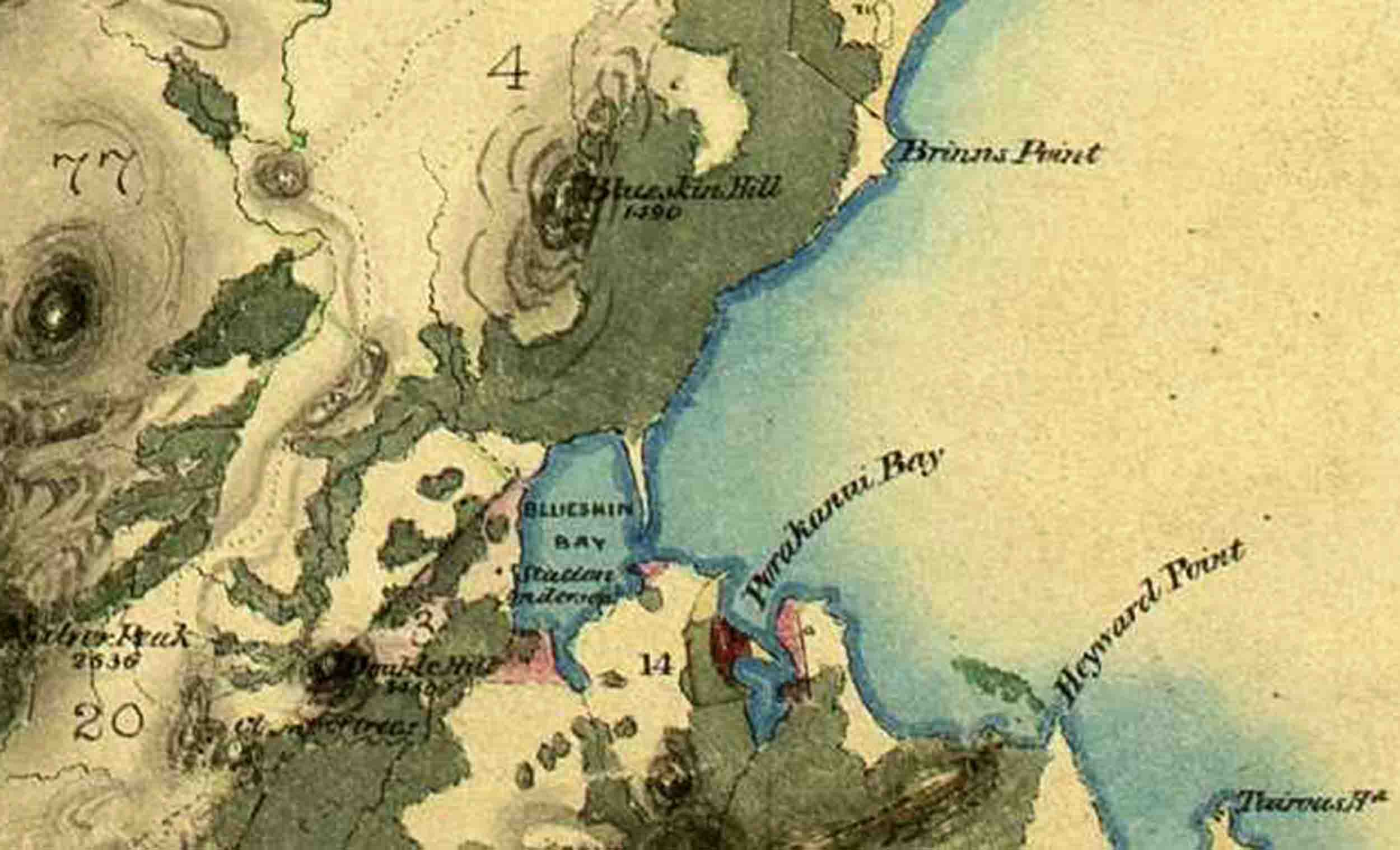
Six years later, another surveyor, John Turnbull Thomson, produced another map, ‘executed during the months of October and November 1857’. On this map, there is a fine dotted line heading generally north-east from Dunedin to Katiki Beach, just south of Moeraki. It is a simple line, with no terminating loops. The dotted line of Thomson’s map overlaps the core part of Kettle’s route (not the loops). I’m assuming that this core route – used to get out of the rather enclosed site of Otepoti-Dunedin, was a well-known footpath.
Thomson’s map was made only nine years after Dunedin’s foundation, but made around 600 years after Polynesians found and settled Aotearoa-New Zealand. Those first inhabitants explored the country amazingly quickly. Virtually the oldest archaeological sites show they had already discovered the best resources (e.g. of pounamu and obsidian) and were utilising them. In other words, we can’t yet put a date on when these resources were found – it was so close to the discovery of the country, that it’s beyond current resolution.
Now here’s the point – there is an implication that the Polynesian settlers rapidly figured out the best ways to get around the land. A network of trails would have quickly evolved, and over centuries, these would have become well-defined by the constant passage of people. Both Kettle and Thomson would have used part of this network to get out of Dunedin.
Thompson’s surveying skills were excellent, and his 1857 map georeferences (‘fits’) extraordinarily well onto modern maps. The closer one looks at it, the more one can see small details – aspects of the coastline, peaks of hills, and even the bends of minor streams, have been accurately drawn. I have no doubt that when Thomson drew the dotted line of that path – its twists and turns reflect reality. Superimposing Thomson’s and modern maps allows us to have a close look at where the old trail ran. In some cases we can see that his dots may be 300-400 m away from the ridge they likely followed. That’s a measure of it’s general accuracy.
From a little north of the Octagon, it’s route went through what are now the suburbs of Wakari and Halfway Bush, then up the western flank of Flagstaff. The present ‘Pineapple Track’ roughly follows the route there, and then along what is now the Swampy Ridge Track and Rollinson’s Rd. From Swampy Summit it skirted ‘The Clump’ (then ‘Clump of Trees’) then along what is now Mountain Track Road. From Steep Hill Rd, it stuck to the ridge to the west of the modern motorway. It crosses farm land (though along a ‘paper road’) until it meets another Mountain Track Road.
It followed the Waikouaiti River down to Cherry Farm, then skirted the hill slope just north of what is now Waikouaiti and former extent of Hawksbury Bush. There is no modern day trail there, but it briefly follows the present highway just north of Waikouaiti. It then took the ridge to the right of the highway, to reach a crossing point on Pleasant River. Rather than cross it where the modern highway goes – perhaps that would have meant a long slog through swamp (‘Flag Swamp is a little further upstream), a short crossing was made over what was mainly tidal flats. On the other side, the trail followed roughly what is now Goodwin Rd, then Bushy Hill Rd.
Then the Shag was crossed, and, curiously, rather than going through the gap where the highway is now, it ascended a spur of the Horse Range and then down a spur on the other side, to Katiki Beach. From here, it was mostly along the beach to Moeraki (today there is no simple public access from the north end of Katiki Beach to Moeraki – though nice if there was – wink, wink).
Throughout Polynesian time, and well into the settler era, there was heavy bush to the north of Otepoti/Dunedin, extending almost continuously to Waikouaiti. The footpath avoided that by taking the unforested high ground to the west. This ridge-route would have been faster, although, as Pakeha were to later find out, it’s an exposed route and bad weather can be fatal to unwary travellers. Cairns were eventually erected on Flagstaff and Swampy to make it safer (Beatie, 2014).
There is still a large patch of indigenous vegetation north of Dunedin, but in an ecological sense, its no longer the forest that it was. Most of the large trees will have been removed from it, and what we see is a canopy of regrowth by smaller trees, or is now a plantation of exotic trees. Only here and there, do a few original larger trees survive.
When Thomson did his mapping, Dunedin was barely a town – the explosive growth of the gold rush had yet to occur. Moeraki, with its Maori kaik was the next village to the north, with just a few scattered ‘stations’ (farms) in between.
As the European settler population grew, the need for roads that could take carts and wagons grew. The footpath out of Dunedin just didn’t cut it for any kind of wheeled transport (including horses and carts). The great forest was logged and partly converted to farmland, and a road was constructed through the lower country, and sometimes directly through the forest. Across New Zealand, many of the centuries-old Maori footpaths fell into disuse. Some were lost, some remained as small tracks, some became the sites of major roads.
Thanks to Kettle and Thomson including it on their maps, we have one of the good indications of an ancient Maori footpath. This makes it one of the oldest cultural features of our landscape. You could think of it as Aotearoa New Zealand’s version of a Roman Road or the ‘Icknield Way’.
Though it no longer exists as a continuous, well-trodden path today, parts of it survive, and can be walked (or cycled) today.
Reference
Beatie, J. 2014. Looking for Arcadia: European environmental perception in 1840-1860. ENNZ: Environment and Nature in New Zealand 9: 40-78.