
One of the beauties of modern archaeological technique is the ability to analyse ancient battle, or massacre sites, in a forensic way. This has happened at the famous Teutoberg Forest site in northern Germany, and is happening in the also famous ‘Tollense’, site in north-western Germany. It’s become known as the earliest battle site in Europe – around 1300-1250 BCE.
The skeletal remains of more than 130 individuals have been located along a stretch of around three kilometers, and concentrated in at least one kilometer of the Tollense River (Jantzen et al. 2011; Lidke and Lorenz, 2019). Many of these bones show signs of violence, and investigators have suggested that they result from “a violent armed clash with at least several hundred (possibly thousands) participants”.
In Germany’s scheme of ‘Natural Regions’, the Tollense is considered as the ‘Hinterland of the Mecklenburg Lake Plateau’ (Number 74). The ‘Mecklenburg Lake Plateau’ region itself (Number 75) is sometimes called “the land of a thousand lakes” – it’s a post-glacial phenomenon, resulting from melting Ice Age ice.
Today, you can walk right up to the bank of the Tollense river, across farmland – while keeping your feet dry. This would not have been possible in the Bronze Age, as the river would have been flanked by wetland. As Lidke and Lorenz (2019) put it, “the Tollense Valley was dominated by vast Carex reeds with open water surfaces”. The present distribution of the highly-organic ‘moor soils’ (‘Niedermoor’ in German – it was the ‘Soil of the Year in 2012! Adler et al., 2002; BUEK1000, 2013) show where these ancient wetlands would have been across northern Germany. Tollense lay near the southern edge of a complex network of wetlands that covered a zone between Tollense and the Baltic Sea coast (see also figure 2 in Kaiser et al., 2012). This is the Mecklenburg-Western Pomeranian Littoral (Number 71) and the Mecklenburg Ground Moraine Lowland (Number 72). The soggy network would have made land-travel across it very difficult, and probably highly-reliant on local navigational knowledge.

The Tollense Battle site in the broader North German geographic context. Green indicates areas of ‘Niedermoor’ soils, that would have been wetlands, the blue indicates lakes (BUEK1000, 2013), brown are better-drained soils. Dotted red lines are boundaries of the German ‘Natural Regions’. Image: the author (Mike Pole).
At Tollense, the high ground on either side of the river was under different soils, like Brown Soil (‘Braunerde’), Pale Soil (‘Fahlerde’), and periodically waterlogged Pseudogley. Although farming was certainly present in the broader area, it’s possible that this higher ground immediately flanking the river may less favourable for this – and consequently been a zone of thick vegetation in the Late Bronze Age.
Despite the very wet conditions, the Tollense seems to have offered the best place to cross over the valley and it may have developed further as the site of a crossroad. To facilitate the crossing, a causeway was constructed (Jantzen et al., 2014, as they were in many other parts of northern Europe at the time). This may have made the Tollense location strategic, but also (certainly if there was thick vegetation on either side) a kind of choke-point (shades of the Teutoberg Forest Battle).
The evidence for a major ‘battle’ (or massacre) might jar our preconceptions of the Bronze Age. For example, the famous Minoan culture of Crete, was Bronze Age as well. It’s ‘golden age’, was the ‘Middle Minoan’, dated to around 2000-1500 BCE. Despite all the images of females it produced, it probably wasn’t a ‘matriarchal’ society, but definitely something that was fairly egalitarian. The Tollense battle has been dated fairly precisely to between about 1300 and 1250 BCE, and therefore, a few centuries younger than the Minoan ‘golden age’. Its large death toll – of mostly young men (DNA identified two women, Burger et al. 2020)- at Tollense, suggests things were not so golden up in northern Germany.
Tensions must have been running pretty high at the time. The killing may have occurred at Tollense because it was a river-crossing, but the broader context remains speculative. Janzen et al. (2010) wrote “there is little doubt that climatic conditions around 1200 cal BC caused general population stress, and may have provoked conflict”. There was series of ‘boom and bust’ cultural cycles over the Bronze Age (Kneisel et al. 2019), but none of these seem to stand out as potential background to the Tollense trouble. There was also an ‘Amber Route’ along which prized fossil plant resin from the Baltic was transported southward. This was probably a diffuse system, but amber likely passed along the Tollense, giving it some additional strategic importance.
Isotopic analysis of the human bones and a typological analysis of arrowheads suggests two groups of people were involved in the Tollense event – locals, and non-locals. Although it was hard to be precise, Central Europe, and more specifically, Bohemia was suggested as “a good possibility” by the isotope group (Price et al., 2019), and “southern Central Europe, in the region of what is today Bavaria and Moravia” by the arrowhead group (Inselmann et al., 2024).
As Price et al. (2019) emphacised, “the non-local combatants … must have traveled long distance to reach the battlefield at Tollense”. For ‘Bohemia’, think (roughly), Prague. If those combatants did go directly from there to Tollense, it would have been a walk of over 500 km – a few weeks. Something, or someone, must have motivated this group to make such an arduous northwards trek, into a situation where they ultimately met their deaths. The DNA evidence concluded (Burger et al., 2020) that “it appears likely that the Tollense individuals were sampled from a relatively homogeneous population with a high degree of continuity to those living in the same broad region today”
During the ‘Late Bronze Age’, the Tollense area fell within the ‘Nordic Bronze Age’ cultural area. The southerners would have come from a different culture (Following figure 2 in Bergerbrant, 2007, perhaps ‘Lausitz Culture’ or Knovitz Milavče Culture), and perhaps distinct enough that the two saw each other as ‘Us’ and ‘Them’.
Getting to the Tollense Battle site from Berlin
Interested in some dark-tourism? You can now get to Tollense and back in a day from Berlin. Not cheaply, but it’s certainly possible to get an hour, or more, on site. Be aware that there is nothing marked, and no obvious signs of archaeological excavation. As far as I know (and the onus is on you to make sure), it’s public access. There are no signs to say ‘Keep out’, and no barriers, like fences. When I visited, the valley seemed to be under a grass crop, and to be respectful, I kept mainly to the wheel-marks.
In detail, I took an RE train from Berlin to Altentreptow. The return ticket (I used the Stadt-Land-Meer-Ticket) cost 49 Euro, which includes some S-Bahn travel in Berlin). From the Altentreptow railway station it’s a few hundred meters to the Liebknecht bus stop (you’ll pass a supermarket if you want some snacks). You want to get to the village of Weltzin, via the Number 300 bus towards Janzen. The bus can be flagged down, and 1.9 Euro cash paid to the driver, and about 15 minutes later, you reach Welztin.

The Liebknecht bus stop in Altentreptow (Image: the author (Mike Pole).
Walk further down the road and turn right onto Lindenstrasse. Just before the large house do a left, then right around the smaller building. The road becomes a two-strip concrete track.

The two-strip concrete track, continuation of Lindenstrasser. Image: the author (Mike Pole).
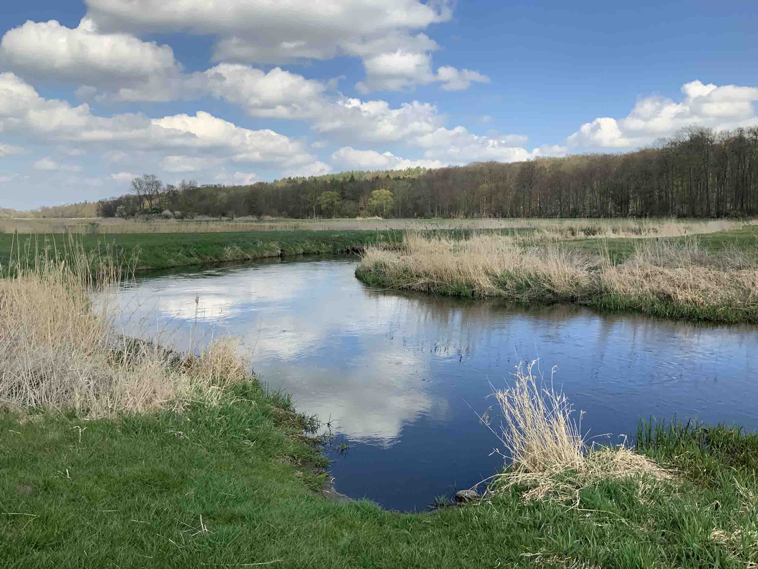
Follow this down, and about the point where the concrete vanishes, and it just becomes a farm track – you’ll be looking down on the Tollense battle area. Directly below you is the site ‘Weltzin 20’ – the most northerly, and downstream, known occurrence of the ‘battle’ remains.

Looing down the farm track onto the Tollense, including the Welztin 20 site. Image: the author (Mike Pole).
Turn right, and you’ll be walking through the zone of bodies. Here and there you may be able to glimpse peat exposed in the river bank – essentially the material that they are found in.

A little peat visible in the river bank (approximate area of Weltzin 13). Image: the author (Mike Pole).
A little further on, you’ll pass Welztin 32, and just before reaching a line of trees, or hedge, to your right – is the site Weltzin 13. The remains of the causeway were uncovered on the other side of the river. I didn’t go there, but there is a cycleway on the other-side.

View downstream – the line of trees/hedge with the track leading back to Weltzin is just visible on the far left. Weltzin 13 is on the left bank, slightly closer. The causeway was on the low ground on the other side of the Tollense. Image: the author (Mike Pole).
I continued on about 220 m (to where the track runs along bushes ot the right) then back-tracked to the line of trees/hedge. A track along here takes you to the right of some solar panels. I never saw anyone on the valley, but on the way out, I met two young local women and their dog. I asked them if there were any issues walking where I had been, and the general tone of the answer was no – and some surprise that I had even wondered.

Looking up the line of trees/hedge with the track going back to Weltzin. The Tollense is behind me. Image: the author (Mike Pole).
At this point another concrete track appears, and leads back into Weltzin. You re-join the road through Weltzin a hundred meters or so before the bus stop. Getting back to Altentreptow by bus seems to be awkward -there don’t seem to be any a useful time. So I just legged it. From the road through Weltzin I turned left, and headed back to Altentreptow. It’s a good eight km, about an hour and a half, but not an easy walk. Once back on the main road, traffic is busy, and there is a metal barrier along its edge, leaving no safe pedestrian space. It’s just rough ground on the other side, but I stuck to that (there may well be other buses you could catch on the main road). From Altentreptow I got the train back to Berlin (If you want to see the Tollense area in a more leisurely way, look up the ‘Eiszeitroute Mecklenburgische Seenplatte’. It’s a cycle route that passes through Altentreptow).

The route of my walk to the Tollense battle site (red dashed line) from Weltzin Village. Some of the sites from Lidke and Lorenz (2019) are marked. Image: the author (Mike Pole) on a base of ESRI satellite imagery.
Once back in Berlin, you could visit the Neues Museum (on Museum Insel) where there is a panel (my understanding is that it’s a cast of the real thing) representing part of the Tollense excavation. Look at all the skulls, and wonder what it was that motivated them…
References
Adler, G., Behrens, J., Eckelmann, W., Hartwich, R., and Richter, A. 2002. Boden im Uberblick. P 100-103 In, Nationalatlas Bundesrepublik Deutschland – Relief, Boden und Wasser.
Bergerbrant, S. 2007. Bronze Age Identities: Costume, Conflict and Contact in Northern Europe 1600–1300 BC. Bricoleur Press.
BUEK1000. 2013. BUEK1000, v. 2.1. Soil Map of the Federal Republic of Germany 1:1,000,000
Burger, J., Link, V., Blo¨cher, J., Schulz, A., Sell, C., Pochon, Z., Diekmann, Y., Zegarac, A., Hofmanova, Z., Winkelbach, L., Reyna-Blanco, C.S., Bieker, V., Orschiedt, J., Brinker, U., Scheu, A., Leuenberger, C., Bertino, T.S., Bollongino, R., Lidke, G., Stefanovic, S., Jantzen, D., Kaiser, E., Terberger, T., Thomas, M.G., Veeramah, K.R., and Wegmann, D. 2020. Low Prevalence of lactase persistence in Bronze Age Europe indicates ongoing strong selection over the last 3,000 years. Current Biology. https://doi.org/10.1016/j.cub.2020.08.033
Inselmann, L., Krüger, J., Schopper, F., Rahmstorf, L., and Terberger, T. 2024. Warriors from the south? Arrowheads from the Tollense Valley and Central Europe. Antiquity, 98:1-19. doi: 10.15184/aqy.2024.140
Jantzen, D., Lidke, G., Dräger, J., Krüger, J., Rassmann, K., Lorenz, S., and Terberger, T. 2014. An early Bronze Age causeway in the Tollense Valley, Mecklenburg-Western Pomerania
– The starting point of a violent conflict 3300 years ago? Bericht der Römisch-Germanischen Kommission, 95: 13–49. https://doi.org/10.11588/berrgk.2017.0.44423
Jantzen, D., Brinker, U., Orschiedt, J., Heinemeier, J., Piek, J., Hauenstein, K., Kruger, J., Lidke, G., Lubke, H., Lampe, R., Lorenz, S., Schult, M., and Terberger, T. 2011. A Bronze Age battlefield? Weapons and trauma in the Tollense Valley, north-eastern Germany. Antiquity. 85(328): 417–433. doi: 10.1017/S0003598X00067843
Kaiser, K., Lorenz, S., Germer, S., Juschus, O., Küster, M., Libra, J., Bens, O., and Hüttl, R. F. 2012. Late Quaternary evolution of rivers, lakes and peatlands in northeast germany reflecting past climatic and human impact ‐ an overview. Quaternary Science Journal, 61: 103‐132. 10.3285/eg.61.2.01
Kneisel, J., Dörfler, W., Dreibrodt, S., Schaefer-Di Maida, S., and Ingo Feeserhttps, I. 2019. Cultural change and population dynamics during the Bronze Age: Integrating archaeological and palaeoenvironmental evidence for Schleswig-Holstein, Northern Germany. The Holocene, 29: 1607-1621. https://doi.org/10.1177/0959683619857237
Lidke, G. and Lorenz, S. 2019. The Bronze Age battlefield in the Tollense Valley – conflict archaeology and Holocene landscape reconstruction, DEUQUA Spec. Pub., 2: 69–75,
https://doi.org/10.5194/deuquasp-2-69-2019
Lidke, G., Jantzen, D., Lorenz, S., and Terberger, T. 2017. The bronze age battlefield in the Tollense Valley, northeast Germany. Conflict scenario research. In: Manuel Fernández-Götz, Nico Roymans (Hrsg.): Conflict Archaeology: Materialities of Collective Violence from Prehistory to Late Antiquity. Routledge, London.
Price, T.D., Frei, R., Brinker, U., Lidke, G., Terberger, Th., Frei, K.M. and Jantzen, D. 2019. Multi-isotope Proveniencing of Human Remains from a Bronze Age Battlefield in the Tollense Valley in northeast Germany. Archaeological and Anthropological Sciences, 11, 33-49.
Wikipedia. Tollense valley battlefield.