

Kawarau map
Part way along the Kawarau River between Cromwell and Queenstown (Central Otago, New Zealand) is a feature known to Maori as ‘Whatatorere’ (Kaumatua Huata Holmes of Kati Huirapa Runaka ki Puketeraki pers. comm. to Lloyd Carpenter, lecturer in Maori Studies at Lincoln University) and to Pakeha (non-indigenous New Zealanders) as the “Natural Bridge” or “Chalmers’ Leap”.
Before bridges were built, it was the only spot along the Kawarau River where travellers could cross the wild river without a boat, or risking their lives trying to swim. The river narrows right down, so that one can either walk, or jump, from one side to the other. The Maori knew all about it. That the bridge was found is testament to how well the Polynesians explored New Zealand. It was a geological miracle that it existed at all, let alone be in virtually the ideal place at the end of the natural trail down the Cardrona Valley, Roaring Meg Stream, and then up the ridge of Mt Difficulty for a relatively easy walk on into Southland. It is highly likely that the crossing was used for more than 600 years.
The first Polynesians would have approached the ‘bridge’ through beech (Nothofagus) forest. The dozen or so beech trees a few kilometres up the Roaring Meg are the last remains of the forest that grew over the southern Pisa Range, and no-doubt extended up Mt Difficulty as well. But this was quickly burnt-off, and the area became a rocky tussock and shrub-land. Generations of Maori would have made their way down through the scrub along what probably became a well-worn trail. Perhaps they rested by the river a while, and then continued on their way.
It would have been used by Te Puoho’s war party as it moved from Wanaka to Southland in 1836. The first European explorer in the area, Nathanael Chalmers was lead over the crossing by the Maori guide Reko in 1853. Reko said it would be a ‘bridge of stone’. There was evidently some element of risk in the crossing at the time – as the European name became “Chalmers Leap”.

The view down the Roaring Meg Ck, with its valley framing Mt Difficulty in the background.

One of two small Hoheria lyallii on the edge of the Roaring Meg. Relict Nothofagus in the background.
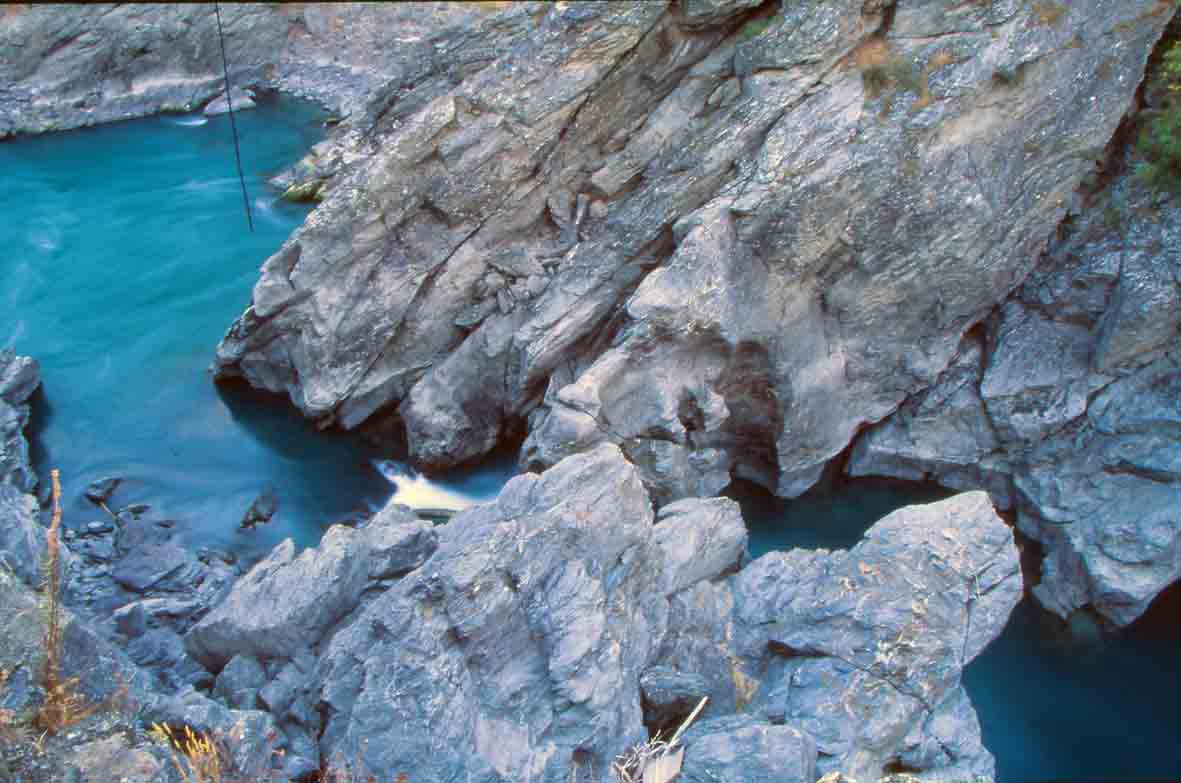
After Chalmers a flood of Europeans came, and, perhaps predictably, some fool blew it up looking for gold (I recall reading this somewhere, but haven’t relocated the reference). As a relative local, I had been brought up to understand that the “Natural Bridge” had gone, but a few years ago I was thrilled to find that this isn’t quite the case. You can, in fact, walk across a rock from the Nevis side (no ‘leap’ involved) – and stand on a rock with the whole Kawarau raging below you. I opted not to try and get up the other side – it’s now a sheer rock wall. However, I’ve since found out that it is possible to work your way up a ‘gut’ in the rock face, but also that the crossing is only possible when the river is markedly low.

The view down to the Natural Bridge from the Mt Difficulty (southern) side.

Standing on a rock with the whole Kawarau River roaring underneath!
That this incredibly ancient and historical focal-point is barely-known, let alone no-longer used (or practically usable), is a tragedy. New Zealand is making leaps and bounds in creating and advertising long-distance walk/cycle-ways. For example, the track from the Cadrona and down the Roaring Meg is a public right of way, but when it reaches the Kawarau – all you have to look forward to is risking your life with the traffic along the periodically narrow road to Cromwell or Queenstown.
What could be done? At Chalmer’s Leap some sort of ladder/bridge arrangement would be needed to rebirth the ancient crossing (argh- safety, liability!!!). Or perhaps the nearby cableway could be modified, or a trail could connect with the bridge at the goldmining/Wild Earth winery. But once on the south side of the Kawarau – there is no longer any right of way over the mountains and down to Southland. “Stuff’ is certainly happening in the area. There is currently a huge operation to clear the ‘wilding pines’ (in this case, Douglas Fir). Hopefully some effort will be made to replace them with some native trees. There has been some native planting along the roadside near the Roaring Meg car park, mostly kowhai and ‘mingimingi’, and towards Cromwell, what looks like an older one, including flax, toi toi, mingimingi and even a couple of Pittosporum.
References For the story of Nathanael Chalmers and Reko, see: Temple, P. 1985. New Zealand Explorers. Great journeys of Discovery. Whitcoulls, Christchurch.
9 comments
Kia ora; great research here. Just to let you know, the Maori name for the feature was Whatatorere. I am a lecturer in Maori Studies at Lincoln University and found this information amongst details provided by Kaumatua Huata Holmes of Kati Huirapa Runaka ki Puketeraki for other research I am doing. Keep up the great research work!
Kia ora Lloyd, many thanks to you and Kaumatua Holmes- I will update the post soon. Funny, I was just thinking of the irony last night, on how Pakeha called it ‘Chalmer’s Leap’. Whatever the goldminers did, the need to ‘leap’ was destroyed, a continuous bridge was simultaneously created – but made it a difficult climb, and only at very low river. Cheers!
Kia ora; great research here. Just to let you know, the Maori name for the feature was Whatatorere. I am a lecturer in Maori Studies at Lincoln University and found this information amongst details provided by Kaumatua Huata Holmes of Kati Huirapa Runaka ki Puketeraki for other research I am doing. Keep up the great research work!
Updated!
[…] blog-post about this very same Natural Bridge with information, map and photos. Discovering the Bridge of Stone – the ancient route over the Kawarau River, New […]
Thanks for this post Mike. Just going through my bookmarks and re-found this article I’d saved ages ago. I remember how pleased I was to find the info as I’d long been aware of the natural bridge – I’d done a lot of reading about Otago settlers and miners when I lived in Queenstown but had been pretty hazy on where the natural bridge had been. A fascinating piece of history!
Thanks Liz! It does seem to be one of the most significant spots in Otago/Murihiku that’s largely off the radar. I fantasise about a bridge being put over there and a hiking trail negotiated down into Southland. Hope the A and P went well. I spent Saturday night in a sleeping bag on top of Mt Grandview.
Hey Mike, I enjoyed reading your post. I have also heard and read about about a gold miner blowing up the natural bridge, but wondered if it is true.
You may be interested to know that there is a natural bridge formed at low water. Below 80 cumecs the whole river goes underground and you can walk across without getting your feet wet. No leaping required.
Crikey, this has just popped up on my alert list! 0-:
Yes, I’ve stood there with the whole river going underneath me, but was still faced with an unclimbable cliff. I’ve heard that if the river gets even lower, it’s possible to sneak around to one side, then up to the main road.