
This year I headed down to the Jurassic fossil forests at Curio Bay, in one of the worst stretches of spring weather I’ve experienced. Lots of rain, and a high, rough sea – but I wanted to have a good look at the zones of bioturbation I’d come across years ago, and get some photos I could use in a blog post. While I was walking back and forwards trying to figure out where the burrows fitted into the broader sequence – there was a kind of light-bulb moment where I thought, ‘Hang-on, am I looking at dinoturbation?’
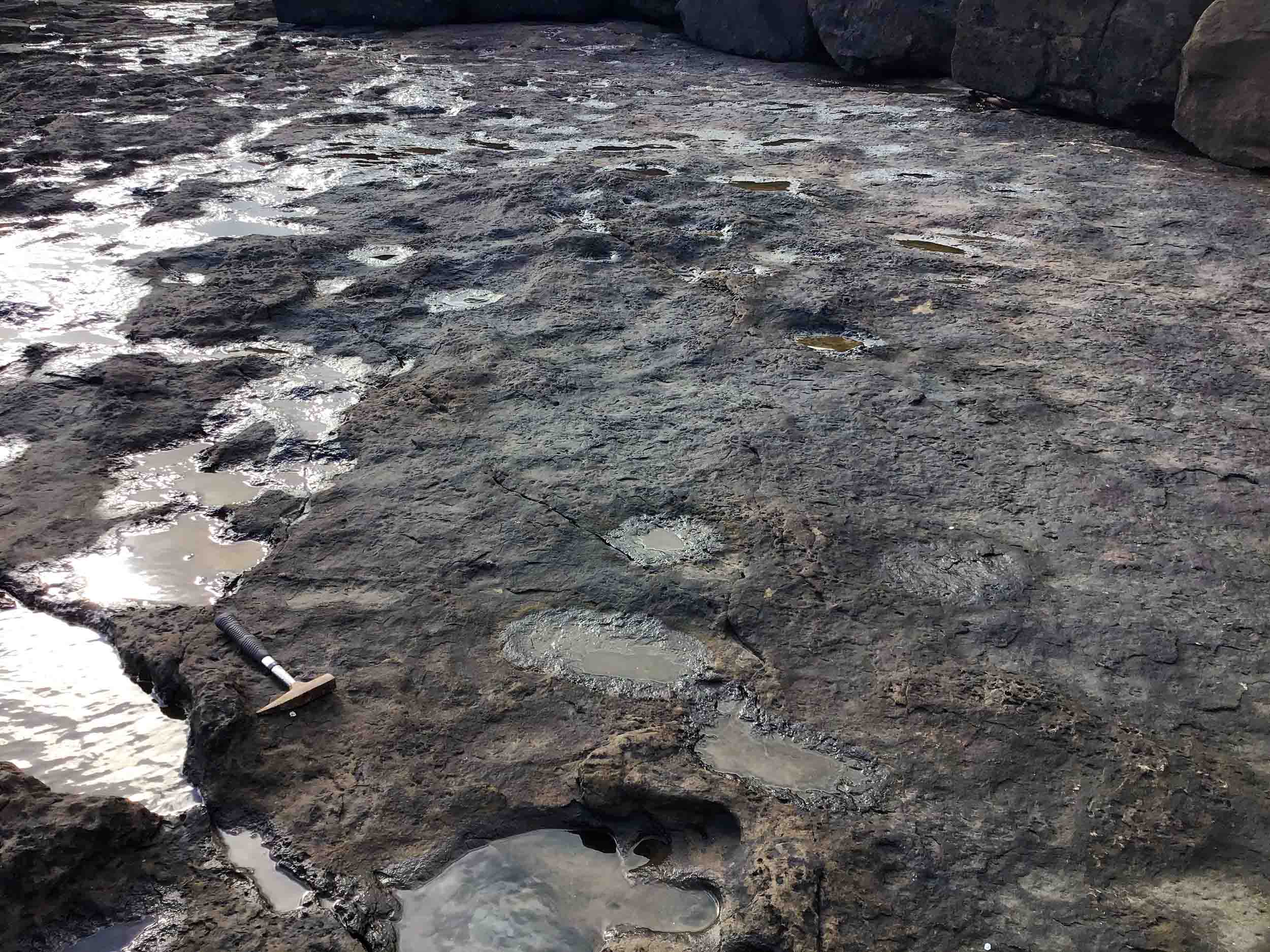
The previous high tide and rain, had left numerous sub-circular depressions, about 30 cm across, partly filled with water. At the right angle, these started to look vaguely like round footprints (See the Featured Image). Back in 2011, courtesy of Dr Steve Salisbury, a vertebrate palaeontologist at the University of Queensland, I got the chance to see the dramatic ‘dinoturbation’ exposed on the Broome coast, of Western Australia. It’s where hundreds of huge footprints are overlapping each other in sandstone along the coast. Here and there were clear toe marks, and in places we could see them in cross section as well (Salisbury et al. 2016).
It was an eye-opener, and the ‘search-image’ of dinoturbation has been tucked away somewhere in my brain ever since (Later, just to prove I do think about dinos, I spotted some little dinosaur footprints in China – it was a satisfying discovery and my colleagues published a paper to describe them: Xing et al., 2016).
At Curio Bay, although the depressions have a broadly similar size and shape, unlike Broome, none are clearly footprints. There is (so far) no ‘smoking gun’ – no toe prints. If they are prints, I suppose they would be from smallish sauropods. Only a few of them have what might be ridges around them – material that could have been squeezed up around the edges of a foot, as it was pressed down. That’s a good sign, except those particular ‘prints’ are probably the least ‘dinosaur-footprint’ shapes of the lot! So was it just my imagination?

Examples of possible dinoturbation in the Jurassic of Curio Bay, New Zealand, on horizontal surfaces. Photo: the author (Mike Pole).
On the plus side, there seem to be only two of these odd layers (one at the base of that little cliff, and one at the top), and they are both stratigraphically close to the bioturbation. Whatever they are, they don’t seem to be just ordinary surface weathering.
Other than at least one ‘perfect’ print, the clincher would be a decent cross-section of one, to prove that these structures have formed as the result of concentrated downward pressure. I couldn’t see any, but on a day when the sea is less angry than what it was, there may be more chances in outcrop nearer the waves. On the other hand, the putative dinoturbation level is at the base of a small cliff. It gives a wonderful cross-section, of what I’ve called ‘floodbasin sediment’, which envelopes some upright fossil tree trunks (extending up from the forest horizon I called CBF7 in Pole, 2001). If there are cross sections of dinosaur footprints, this is exactly the place where they ought to be clearly visible.
A close look along the cliff, indeed, showed up maybe three structures, all at about the same level (mid way up the cliff) over a stretch of about thirty meters. They stand a reasonable chance of being cross-sections of the imprints of large feet. The key observation is that lower layers, that were surely once horizontal, have been depressed. And in one instance, apparently detached from the rest of the layer, as it was pushed down. There are similar structures on the other side of North Head (facing the Brothers) as well as some other soft sediment deformation, that may be of entirely different origin.

Examples of possible cross sections of dinosaur footprints in the Jurassic of Curio Bay and North Head, New Zealand. Photo: the author (Mike Pole).
These don’t seem to be some sort of scour, that has happened on the base of a river channel (from the action of a water current), but there are other natural mechanisms to consider. They fall into the category of what geologists call ‘soft-sediment deformation’. A layer of wet, relatively dense sediment deposited on a layer of wet, less-dense sediment can have striking results. The lower sediment can rise-up in ‘pillow’ like forms, that might have a passing resemblance to what a big dinosaur foot might do (see this blog post). Also, the formation of ice within sediment can do odd things, and an earthquake giving wet sediment a good shake (kiwis can think of the ‘liquefaction’ that happened during the Christchurch Earthquake). I wouldn’t rule out any of these things from being present in the Jurassic rocks of the wider Curio Bay area, but in this cliff outcrop, none of these explanations seems to fit. The most simple explanation for these structures is that they were formed by the downward pressure of a large foot, with a lot of weight behind it. They compare fairly well with Late Cretaceous structures in New Zealand, that have been interpreted as cross-sections of dinosaur footprints (Browne, 2009). The Curio Bay phenomena are not the overlapping footsteps of ‘dinoturbation’ – but quite possibly some widely-spaced foot steps that would be expected in associated layers.
Although the Curio Bay environment was not overtly a wetland, in the sense of peat/coal forming, the signs of a floodbasin and standing bodies of water are encouraging. They are likely to have been other wet, muddy, or silty surfaces which, if dinosaurs crossed, would have left nice foot and maybe tail-prints. There’s a layer of “convolutions” at the south end of the ‘Boat Harbour’ that I illustrated in Pole (2004, fig 11). In hindsight, they are quite possibly dinosaur footprints.
At the moment, the jury remains out – perhaps there’s an 80% chance that these are dinosaur footprints? It would be nice to confirm. We can be sure dinosaurs inhabited New Zealand in the Jurassic, but so far there is no confirmed trace.
References
Browne, G.H. 2009. First New Zealand record of probable dinosaur footprints from the Late Cretaceous North Cape Formation, northwest Nelson, New Zealand Journal of Geology and Geophysics, 52: 367-377, DOI: 10.1080/00288306.2009.9518464
Pole, M. 2001. Repeated flood events and fossil forests at Curio Bay (Middle Jurassic), New Zealand. Sedimentary Geology, 144, 223-242.
Pole, M.S. 2004. Early ‑ Middle Jurassic stratigraphy of the Fortrose‑Chaslands region, southernmost South Island, New Zealand. New Zealand Journal of Geology and Geophysics 47, 129-139.
Salisbury, S.W., Anthony Romilio, A., Herne, M.C., Tucker, R.T., and Nair, J.P.. 2016. The Dinosaurian Ichnofauna of the Lower Cretaceous (Valanginian–Barremian) Broome Sandstone of the Walmadany Area (James Price Point), Dampier Peninsula, Western Australia. Journal of Vertebrate Paleontology, 36 (supp 1): 1-152. https://doi.org/10.1080/02724634.2016.1269539
Xing, L., Lockley, M.G., Wang, Y., Pole, M.S., Klein, H., Peng, G., Xie, Zhang, G., Deng, and Burns, Me. 2016. New Middle Jurassic dinosaur track record from northeastern Sichuan Province, China. Swiss J. Palaeontol. DOI 10.1007/s13358-016-0123-4
Acknowledgments
Thanks again to Christine Mackenzie and family for the much-appreciated hospitality.