
Do we have a submerged ‘Doggerland‘ in New Zealand?
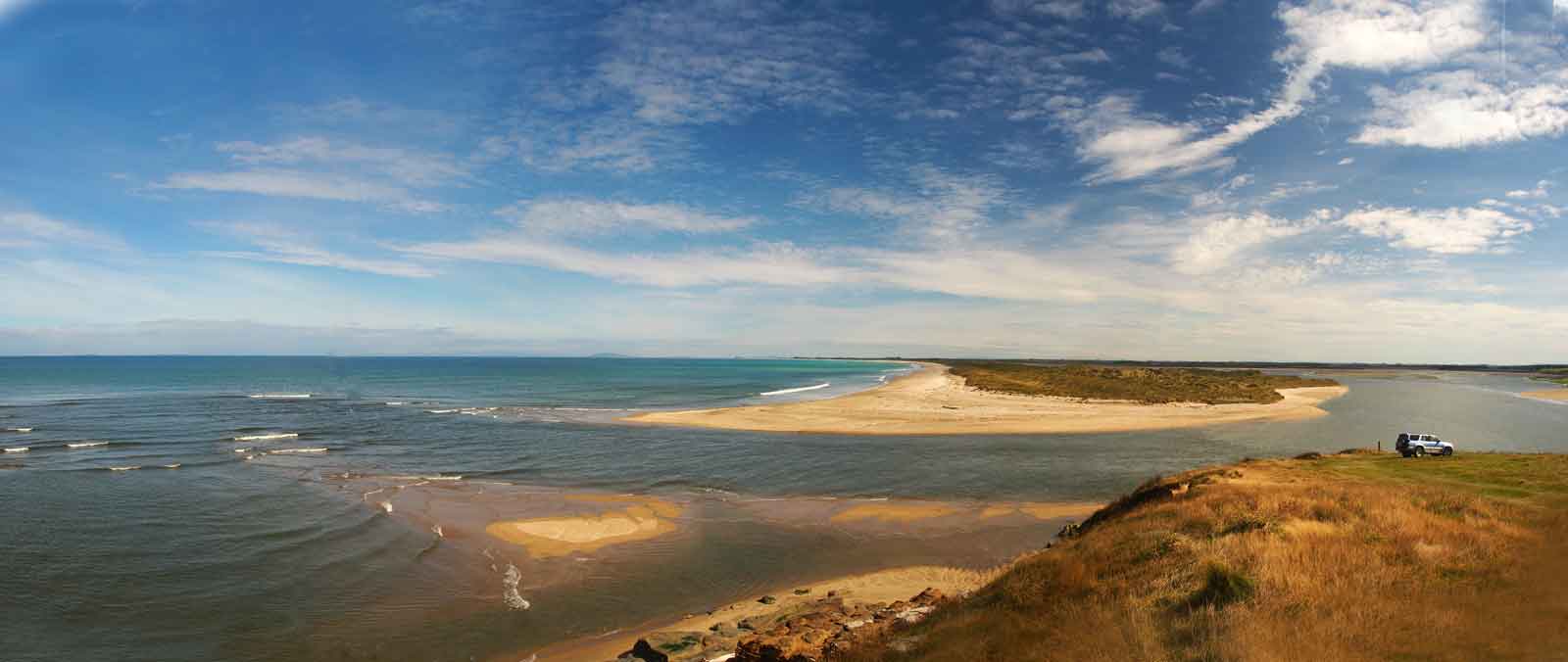
In 1950 a boat, the HMNZS ‘Lachlan’ dredged a sample of “lignite” from the bottom of Toitoi (or Toetoe) Bay, at the far south end of New Zealand’s South Island, from a depth of nine fathoms (the general view shown in the featured image. See below for more details). The sample was forwarded to R.A. Couper, a New Zealand specialist in fossil pollen.
To concentrate the pollen (by eliminating as much as possible of everything else) Couper boiled up a little bit of the lignite in potassium hydroxide, stained it, and put it under a microscope. He found it was dominated by beech pollen (Couper, 1951), but also a lot of other plants that you would expect in a peat swamp (like Sphagnum moss, sedges and the tangle-fern) and the surrounding swamp forest (like kahikatea and rimu).
There were two surprises here. One was that in among all the usual suspects, Couper spotted three types of spore that were both unknown in New Zealand’s current flora and still undescribed as fossils. In other words, they were extinct and new to science, although one was not new to him – he recognised he had also seen it in a lignite near Wanganui. He later (Couper, 1953) named this Peromonolites problematicus. The other surprise was that it was dominated by pollen of the southern beech (Nothofagus), whereas the regional pollen today would be mainly conifers (like rimu). Both of these points suggested a reasonable age for the lignite, and Couper argued that it was Pliocene (currently regarded as about 5.3 Ma to 2.6 million years ago).
A few decades down the track, Couper’s extinct species was renamed as Bryosporis problematicus (Bussell and Mildenhall, 1990), with the authors concluding that its age range was Pliocene – mid Pleistocene (so possibly extending to a few hundred thousand years ago), although they hedged, adding that it “may be an extant spore type”. Despite this uncertainty, the known age range supports Couper’s initial broad conclusion for the age of the Toetoe Bay lignite.
That chunk of lignite is the compressed remains of what would have been a peat swamp, or swampy forest, which grew under what is now Foveaux Strait. It is in some ways, New Zealand’s example of the now famous ‘Doggerland’ which has been discovered below the North Sea.
The relatively shallow Foveaux Strait would have been fully exposed at the peak of each ice age (when global sea levels fall), and only totally submerged at peak interglacials. However, at peak emergence, conditions were probably too severe for forest. To give an idea of what our Doggerland may have looked like at one point in time, I’ve mapped the 50 m depth mark for the area. At the height of glacial maximum, it would have been even more extensive. In reality, the exact shorelines at any point in time are harder to determine – New Zealand lies on a geological plate boundary, causing our west coast to rise, while the east subsides.

Relicts of our Doggerland are found on land, here and there, on the coasts surrounding Foveaux Strait. They are beds of peat/lignite exposed in the cliffs, which are being eroded by the waves, but would have once extended out into the sea. I’ve looked at various samples of this material for fossil leaf remains. What I’ve seen has a lot of kahikatea (Dacrycarpus), as well as swamp broom (Carmichaelia), flax (Phormium), and other species, although no extinct ones. They indicate that a similar mosaic of peat swamps and swampy forest which once grew all over Southland, once extended out over what is now sea floor. However, when I’ve looked for fossil pollen, I’ve seen no Nothofagus beech at all (but lots of ferns and kahikatea). This suggests that my samples and Couper’s represent different times of our Doggerland’s history.

Last year, in the company of Christine, whose family owns one of the farms nearby – one of the southernmost farms in New Zealand, we drove to the mouth of the Mataura River. On the cliffs below us were some of those pockets of peat/lignite. From our vantage point on the hill, we could see more or less where Couper’s sample had been dredged from (somewhere along a line of sight between Bluff Hill and Ruapuke Island).

So was this really our ‘Doggerland’? There is an important difference – the ‘original’ Doggerland had people living on it. It has become famous because of the recognition that just below the waves, an entire Mesolithic landscape, is, or at least was, nearly perfectly preserved. Over the last century or so, trawling by fishing boast has uncovered a wealth of bones, stone tools, and even woodwork dating back to around 6500–6200 BC. Unfortunately, the very activity which made the discovery, has probably destroyed most of it. Even as far back as 1913, Clement Reid in his book ‘Submerged Forests‘ (you can download his book for free here), wrote that when “trawlers first visited the Dogger Bank its surface seems to have been strewn with large bones of land animals” but “now the whole surface of the Dogger Bank has been gone over again and again by the trawlers, and very few of the fossil bones are found”. It’s rather sad, but poignant and also topical (given current sea level rise) to consider that Doggerland was a home to people who would have been aware that it was vanishing. How they may have felt about this was explored in Jim Leary’s book ‘The Remembered Land: Surviving Sea-level Rise after the Last Ice Age‘.

But ‘our’ New Zealand Doggerland, is much older. To put its age in perspective, it is far younger than the Jurassic fossil forest horizons which are found along the same coast, and further afield at Curio Bay. They are also younger than the woody lignites which are scattered across Southland and are around 20 million years old. Our Doggerland lignites are likely to be between a few tens of thousands and maybe a couple of million years old. Therefore, New Zealand’s example never had humans living in it, as New Zealand was only discovered about 700 years ago (but note that one of its topographic highs, Ruapuke Island, would become the stronghold of the Southern Maori).

While ‘Doggerland’ seems to have become the most common name for the flooded North Sea landscape, Leary (2011, 2015) has been pointed out that by priority, its name should be ‘Northsealand’ (we have no idea what the original inhabitants called their home) as this is the term coined by Child in 1958. Furthermore, the ‘Dogger Banks’ are actually rather recent sedimentary features which have accumulated since the flooding of Doggerland/Northsealand landscape.

What should we call New Zealand’s Doggerland? You might think that as it is now under the waters of Foveaux Strait, it could be called ‘Foveauxland’. However, just as ‘Northsealand’ has priority over ‘Doggerland’, the Maori name, Te Ara a Kiwa (‘the path of Kiwa’) or Te Ara a Kewa (‘the path of the whale’), takes priority over the European Foveaux Strait.
I’ll leave it to someone else to work out an appropriate name….
***
Just a final comment. Back in 2000 Tony Roberts and I were on a 10 day walk around Stewart Island. We’d diverted down to Port Pegasus for four days, then crossed over to the west coast. By the time we reached the deserted Masons Beach, we hadn’t seen anyone for days (not counting hearing a raucous party on a fishing boat moored offshore Pegasus). The next morning we went off exploring the area behind our camp. Out of some high sand dunes we saw some long thin bones protruding. I wasn’t sure what they were, but a little voice in my head told me not to pull them out for a closer look. Instead, we went down to the beach – and found something else of more relevant interest. The low-tide had exposed a bed of ‘lignite’ offshore. I sampled a piece and much latter found it to be full of rata leaves – it was another fragment of New Zealand’s Doggerland. But just after I grabbed that lump of lignite, a helicopter landed – and a small group emerged to announce that they were archaeologists coming to investigate the human skeleton which was eroding out of the sand hills in the distance.
I still have nightmares at the thought of standing in the dunes, clutching a human bone, just as those archaeologists arrived to carefully excavate them….
References
Childe, V.G. 1958 [2009]. The Prehistory of European Society. Nottingham, Spokesman Books (reprint edition)
Couper, R.A. 1951. Microflora of a submarine lignite from Toetoes Bay, near Bluff, New Zealand. New Zealand Journal of Science and Technology, B33:179-186.
Couper, R.A. 1953. Upper Mesozoic and Cainozoic spores and pollen grains from New Zealand. New Zealand Geological Survey Palaeontological Bulletin n.s., 22:1-77.
Leary, J. 2011. Experiencing change on the prehistoric shores of North Sea land: an anthropological perspective on Early Holocene sea-level rise. In: Benjamin, J., Bonsall, C., Pickard, C. & Fischer, A. (eds) Submerged Prehistory. Oxbow Books, Oxford.
Leary, J. 2015. The Remembered Land: Surviving Sea-level Rise after the Last Ice Age. Bloomsbury Academic.
Reid, C. 1913. Submerged Forests. Cambridge University Press.
Royd Bussell, M. & Mildenhall, D.C. (1990) Extinct palynomorphs from middleand late Pleistocene terrestrial sediments, South Wanganui Basin, New Zealand. New Zealand Journal of Geology and Geophysics, 33:3, 439-447, DOI: 10.1080/00288306.1990.10425699
3 comments
Really love the photo of the mouth of the Mataura River. We enjoy an occasional visit to the cafe at Fortrose but we haven’t been out above that view. Is there access to that spot via the golf course?
Fascinating as usual, yet another reminder that I need to visit the forgotten corner (Catlins) with time to explore. But ‘tree fern’? Given the scale provided I would have thought Blechnum discolor would be the best candidate in extant flora. Oddly though, Southland is the only place where I have encountered crown fern approaching tree fern size, with the tallest around 7ft.
Thanks Graeme, yes, time for you to visit. I always regarded the Catlins as the ‘forgotten corner’, but it’s been very much discovered in the past few years – with major road reconstruction!
I will definitely take your Blechnum discolor suggestion on board. The ‘fossils’ are certainly small, and I’m using ‘tree fern’ loosely, in that they are trunks. The fossil spores are dominated by Cyathea.