
We’ve all read Dr Seuss’s ‘The Lorax’ – right? The Lorax spoke for the trees. In the book, Truffula Trees are seen as a resouce, and eventually an entire forest of them gets cut down. In the early days of Dunedin, the trees weren’t so much as a resource, but were something to be cleared for the town, and for farmland.
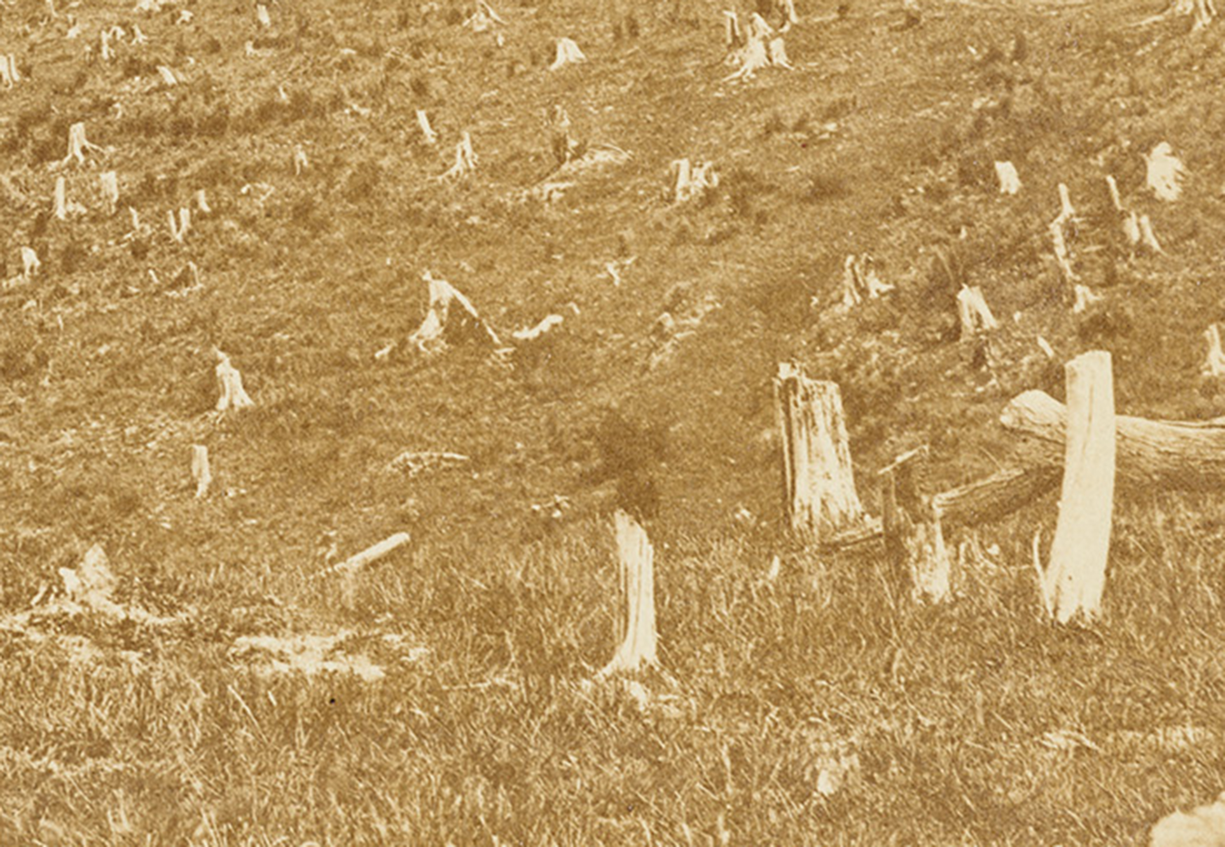
There’s one old photograph of Dunedin that always brings ‘The Lorax’ to my mind. It’s Allan Houston’s ‘View of Dun Edin. Otago. New Zealand’, which (according to the description on the Hocken Collections | Te Uare Taoka o Hākena web-page), he bought for five shillings in 1865, and shows Dunedin ‘as it was 3 or 4 years ago’. My pick is that the photo was taken in what is now the suburb of Dalmore, a little off Dolphin Street.

Left: Houston, A. c. 1862. ‘View of Dun Edin. Otago. New Zealand.’ Reference Number Misc-MS-1413/057. University of Otago Library Digital Collections, Hocken Collections | Te Uare Taoka o Hākena. Right: My approximation of the view using Blender, LIDAR topography, and superimposed on ESRI Street Map – created using ArcGIS® software by ESRI – World_Street_Map. Copyright © Esri. All rights reserved. Sources: Esri, HERE, Garmin, USGS, Intermap, INCREMENT P, NRCAN, Esri Japan, METI, Esri China (Hong Kong), NOSTRA, © OpenStreetMap contributors, and the GIS User Community.
In the foreground is a slope, covered in the bleached, and possibly burnt stumps of trees. They’ve been roughly cut down at about waist height. There are few signs of logs. Between the stumps is pasture, and a cow is in sight. A fence (possibly where the logs ended up) keeps the cow off what seems to be a road (possibly Bank Street – Pine Hill Rd) on the other side. Dunedin is in the distance, with George and Great King Street running down to the Bell Hill – Octagon area. What are now the parallel Cumberland, Castle, and Leith Streets, seem to be nothing more than spaces between more fence lines.
The particular image in The Lorax that I’m thinking of, is the one where every last Truffula Tree is now represented only by a stump, and in the background, there’s a factory. Below that image, the text reads”
“And at that very moment, we heard a loud whack!
From outside in the fields came a sickening smack
of an axe on a tree. Then we heard the tree fall.
The very last Truffula Tree of them all!”
But in Houston’s photograph, a forest occupies the mid-distance. It’s clearly very disturbed, with buildings scattered through it, but it still retains tall, clearly ancient trees. The forested strip runs around to what is now the end of the Dunedin Botanic Gardens, above Dundas Street. Those trees are hiding the Water of Leith from sight.
At about the same time as the south-facing photo that ended up in Houston’s hands was taken, the Burton Brothers took two panoramic photos from View Street (above the Octagon), looking north, over the growing town. In the murky distance, the slopes of Mount Cargill and Signal Hill are a patchwork of lighter cleared areas, and darker untouched forest. Bleached stumps appear to cover the ground just below Pine Hill Road – right on the limits of resolution of the image. But you can clearly see the that remaining belt of forest, between the city, and the farmland on the hill slopes. It stretches from Woodhaugh Gardens (where a few tall trees, thankfully, remain today), around to the Botanical Gardens, and on to the former delta at the mouth of the Leith.

Left: Burton Brothers. 1861. ‘Dunedin from View Street 1861’. Dunedin Public Libraries and the Dunedin Lebanese Community: He Purapura Marara, Scattered Seeds. Right: Meluish, W. 1860. ‘Dunedin from Maitland Street’. University of Otago, Digital Library, Hocken Collections | Te Uare Taoka o Hākena. Reference Number P1990-015/47-012.
Another northward-looking photo was taken by William Meluish, in 1860, above Maitland Street, to the south of the city. It also looks out on bleached stumps, and more of those fences. It shows a patch that’s been hacked out of bush – that still stands on the other side of the fences. On the distant Pine Hill, Mount Cargill and Signal Hill, that patchwork of clearing can still, just be made out.
Two more images of about the same vintage, look across the Harbour towards the Otago Peninsula. One is the 1864 watercolour by William Handcock (‘City of Dunedin’). It was made from above High Street, and the view extends from the lower Leith Valley/North Road, across Pelichet Bay, the Harbour, Waverley, Macandrew Bay, and St Kilda. We can see defined edges between bush and pasture in the Signal Hill area, and on the Otago Peninsula, right in the middle of a cleared square of bush, sits Vauxhall Gardens.

Left: Handcock, W. 1864. ‘City of Dunedin’. University of Otago, Digital Library, Hocken Collections, | Te Uare Taoka o Hākena, Accession Number 14,417. Right: Liardet, W.F.E. 1865. ‘View of Otago Peninsula opposite Dunedin, showing Vauxhall Gardens’. University of Otago, Digital Library, Hocken Collections | Te Uare Taoka o Hākena, Accession Number 12,222.
Handcock’s image shows other sharp-edged patches at the base of the Peninsula, but the forest remains connected, and the high ground beyond remains under bush. A lithograph made in the following year, by Wilbraham Liardet, shows a more restricted view across Otago Harbour, towards what are now Waverley and St Kilda. It appears to have been imagined from about 130 m above the Harbour. Large bush clearings are also apparent and made up to defined property boundaries, the most prominent is, again, that containing the ‘Vauxhall Gardens’. But they are clearings within the bush – you could still have walked, or even flown, all the way from Andersons Bay, out into the middle of the Peninsula – and essentially remained under a forest canopy.
These few images, added to the evidence of remaining vegetation and early maps, allow the creation of a map showing roughly the situation around Dunedin in the early 1860s.

Dunedin area in the early 1860s. Green = remaining forest. Yellow = standing stumps in farmland. Base map is the LINZ 1:50,000 topo map (1 km grid). Image: the author (Mike Pole)
Dunedin’s historian, Ian Dougherty (2007) has written a book about the Vauxhall Gardens. They appear to have been, something of a local den of iniquity, created as the population surged with immigration as the Gold-Rush took off. (See also the blog: In Loving Memory: ‘Vauxhall Gardens – “the haunt of prostitution and debauchery on a grand scale“’)
Dougherty (2007) wrote:
“Farley’s men cleared the dense bush from part of the gently sloping hilltop site and drained and laid out the grounds. In the center of the clearing they built a wooden rotunda for dancing …. Statues were erected throughout the grounds and ‘labyrinthine walks’ cut through the thick bush on either side of the hotel”
Dougherty added a quote from The Otago Daily Times (31 Dec 1862, p 4):
“The result is a practical edition of, a “New Zealand Bush Made Easy;” for while sauntering along these paths – here matted with rich grass or clover, there inlaid with twisted and laced roots – the visitor may see on either hand, good illustrations of how “bush lawyers” creep and cling, how supple-jacks hang pendulous and woven into screens, how charmingly fresh ferns and sombre pines form natural arches and bowers, and of what a wealth of beauty there is, even in a single fern or cabbage tree, when fairly examined amidst its native woodlands wild.”
But, as Dougherty (2007) found, by 1872, after the gold-boom had passed, the Vauxhall Gardens had declined to ruins. They were then subdivided for housing. The ‘woodlands wild’ had vanished – in fact, virtually all forest was eventually removed the Otago Peninsula. And within a few years, that entire strip of dense forest, running along the Water of Leith, had vanished too (OK, not entirely – the few trees at Woodhaugh remain, and for those we are eternally grateful).
***
What would the Lorax have said, back in about 1861? If he was looking down from Dalmore, on all those stumps, perhaps: “Well-done, give those guys a beer”. It was, after-all, bloody hard yakka to cut them down (without a ‘Super Axe Hacker’). But he may have added – “Just leave those trees on either side of the Leith”. They could have, and should have, been sacrosanct. In the absence of an actual Lorax, somebody ‘in-charge’ – an adult in the room, could have surveyed off a decent marginal strip. On the Peninsula, The Lorax may have suggested a compromise – just leave a network of forested strips, almost like hedges.
In 1864, with a little planning, and foresight, there was still a chance.
References
Dougherty, I. 2007. ‘Vauxhall Gardens: Dunedin’s Notorious Victorian Pleasure Gardens’, by Saddle Hill Press. Links to ebook versions are here, and here.
Seuss, Dr. 1971. The Lorax. Random House.
Graphic sources
Burton Brothers. 1861. ‘North East Valley from View Street, Dunedin in 1861′. Dunedin Public Libraries and the Dunedin Lebanese Community: He Purapura Marara, Scattered Seeds. “This work is licensed under a Creative Commons Attribution-Noncommercial-No Derivative Works 3.0 New Zealand License This licence allows you to download this work and share it with others as long as you mention us and link back to us, but you cannot change it in any way or use it commercially.”
Burton Brothers. 1861. ‘Dunedin from View Street 1861’. Dunedin Public Libraries and the Dunedin Lebanese Community: He Purapura Marara, Scattered Seeds. “This work is licensed under a Creative Commons Attribution-Noncommercial-No Derivative Works 3.0 New Zealand License. This licence allows you to download this work and share it with others as long as you mention us and link back to us, but you cannot change it in any way or use it commercially.”
Handcock, W. 1864. ‘City of Dunedin’. University of Otago, Digital Library, Hocken Collections, | Te Uare Taoka o Hākena, Accession Number 14,417. “No known copyright or other restrictions on use exist in this image.”
Houston, A. c. 1862. ‘View of Dun Edin. Otago. New Zealand.’ Date c.1862. From Collection Houston, Allan: ‘The Gold Fields of Otago’ Ōtepoti / Dunedin. Reference Number Misc-MS-1413/057. University of Otago Library Digital Collections, Hocken Collections | Te Uare Taoka o Hākena. “No known copyright or other restrictions on use exist in this image.”
Liardet, W.F.E. 1865. ‘View of Otago Peninsula opposite Dunedin, showing Vauxhall Gardens’. University of Otago, Digital Library, Hocken Collections | Te Uare Taoka o Hākena, Accession Number 12,222. “No known copyright or other restrictions on use exist in this image.”
Meluish, W. 1860. ‘Dunedin from Maitland Street’. University of Otago, Digital Library, Hocken Collections | Te Uare Taoka o Hākena. Reference Number P1990-015/47-012. “No known copyright or other restrictions on use exist in this image.”
http://server.arcgisonline.com/arcgis/rest/services/World_Street_Map
“Map created using ArcGIS® software by ESRI – World_Street_Map. Copyright © Esri. All rights reserved. Sources: Esri, HERE, Garmin, USGS, Intermap, INCREMENT P, NRCAN, Esri Japan, METI, Esri China (Hong Kong), NOSTRA, © OpenStreetMap contributors, and the GIS User Community