
One part of Dunedin is different from the rest….
The Dunedin area is an old volcano. It’s formed mostly from the molten, or semi-molten material that forced its way up from below, or some of the older marine strata that this material pushed its way through. In the few million years since the Dunedin volcano lived, and died, what was a more or less a conical mountain, has deeply weathered, and been dissected by erosion (the Otago Harbour was cut by streams that once flowed radially out from the central crater). Most of Dunedin lies on weathered volcanic rock, marine sediment, or slumps of that material.
However, the lower Leith and North East Valleys have been built up by fluvial processes, as gravel, sand, mud have worked their way down the stream channels. During floods, the Leith and Lindsay Creek overtopped their banks – and dumped coarse material nearby the channel, and caused the growth of a natural levee. The finer muds in suspension would have settled out further away. Occasionally, floods may have led to new channels (a ‘cut-off shute’ appears to have formed near the southern end of the Botanical Gardens). All this would have built up a micro-topography: slightly higher and better drained areas close to the channel, and muddy swamps away from it.
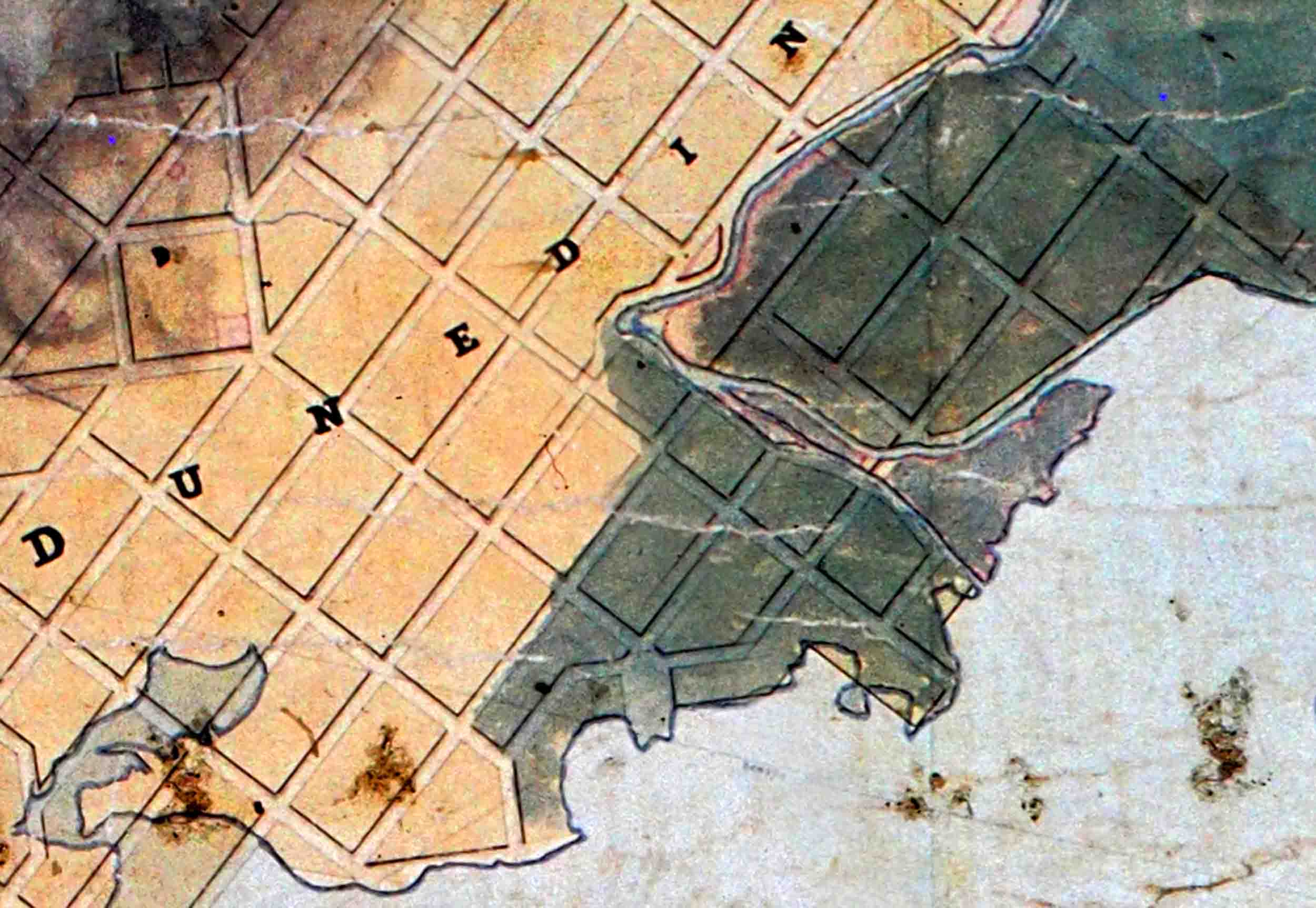
At the extreme end of this alluvial system, the mouth of the Leith was a genuine river delta. The early maps of Dunedin are clear on this – just a few hundred metres upstream from where the Leith entered the Otago Harbour, there was an island, and the Leith split into two diverging channels, encompassing two more islands. The ‘Leith delta’ projected into Otago Harbour to form a bay on its left (north) side – Tauraka Pipipi, or Pelichet Bay (sometimes Pelichet’s Bay).
Early maps and photos are also clear on another point – that the Leith and North East Valleys were mostly heavily forested when the first European settlers arrived (This contrasts places like the Exchange and Octagon, that were under scrub, flax or grass at settlement).
An 1847 map by Charles Kettle (i.e. two years before the first Emigrant ships arrived), shows the Leith delta as forested (though the islands are in a lighter shade of green). The western edge of solid bush (indigenous forest) ran from about the corner of Leith and Hannover Street, along Leith Street as far as Dundas St, and then diagonally (north-west) towards Woodhaugh. The non-forested country west of this line, probably included much flax wetland. From the low alluvial ground, the forest extended up the steeper, rock-based slopes of Flagstaff, Mount Cargill, and Signal Hill, Waitati and beyond.
Early photographs and paintings show tall forest right down to the high tide mark at the end of the Leith delta. (see the Burton Brothers’ photograph ‘Dunedin from View Street, 1861’, Dunedin Public Library, ‘He Purapura Marara, Scattered Seeds’). Newspaper reports emphasise that the forest was extremely wet, and we can assume that much of it was a form of ‘swamp forest’. Those little topographic and drainage differences, created by fluvial processes, would have been important controls on what trees dominated, where. Perhaps more kahikatea in the back-swamps, and more rimu on the levees, and maybe even kowhai. Thus, the Leith Valley and its delta, was a rather distinct ecosystem – an alluvial forest.
At European settlement, the Leith bush would have been teeming with native birds. As well as the ones that survive in the area today, like tūī , kererū, and pīwakawaka, there were also kiwi, saddleback, and yellow heads. Other species, now extinct or nearly so, were likely in there as well. The whole system – the alluvial valley and the delta, sounds like an ecological paradise. Oh, to have got in there for even a week, before it was all wiped away!
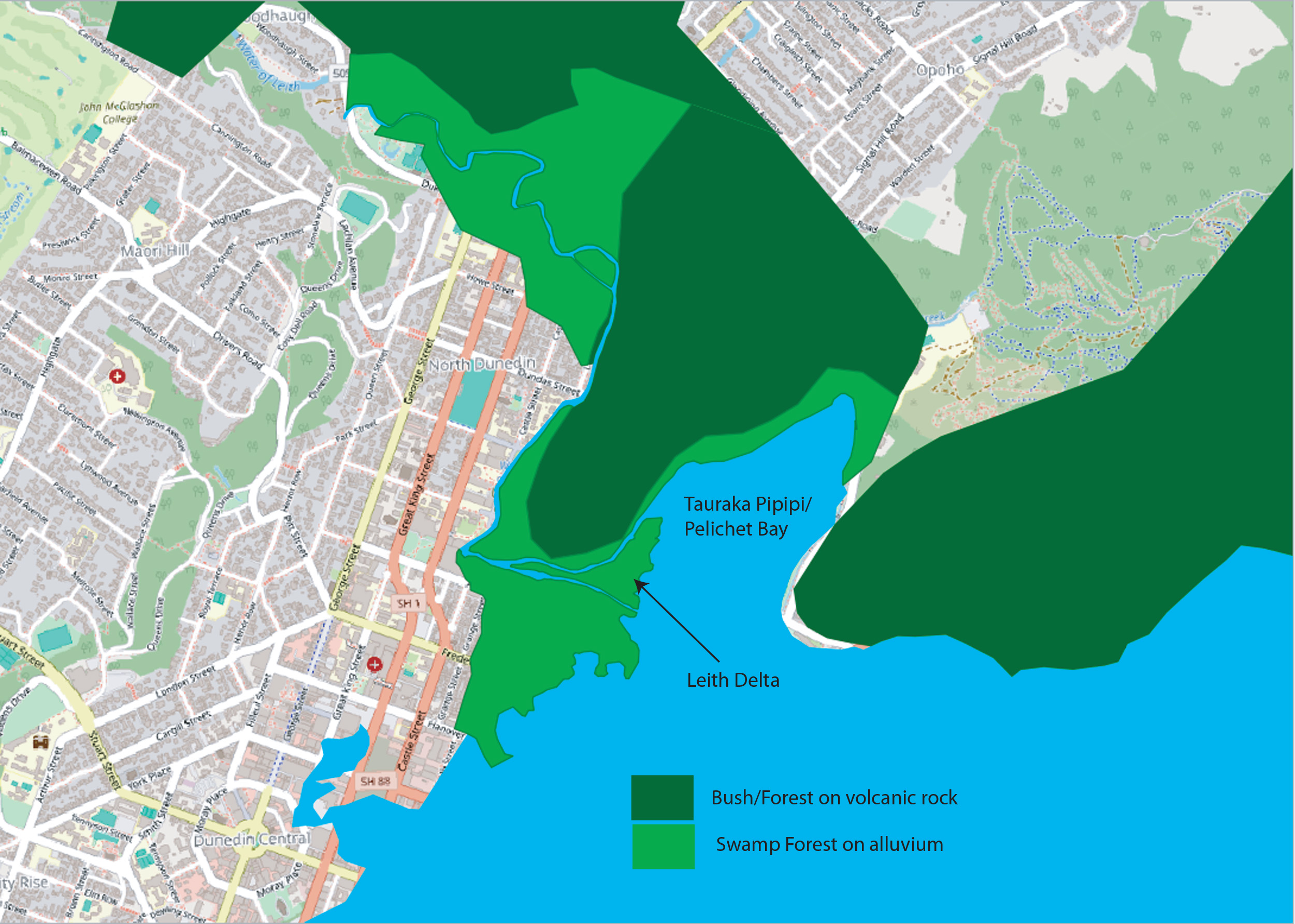
The 1847 distribtion of swamp forest on alluvium (light green) and bush/forest on volcanic rock (dark green). Alluvium distribution taken from GNS 1:250,000 QMap, Dunedin. Shown over Google Street Map for orientation (Image, the author: Mike Pole)
Of course, the drivers whose horse-drawn drays were overturning in the mud that passed for ‘roads’ a century and a half ago, saw it from a rather different point of view. A surveyor’s map was abstracted onto the valley, with a main road heading up Northeast Valley, and regular side roads coming off at rights angles up the crazy-steep slopes. In between, dozens of rectangular lots were marked out. The new owners rapidly set about clearing the forest from their lots, and turned the survey map into reality.
John Turnbull Thomson’s 1856 painting of Dunedin from Andersons Bay (Hocken Collections, Uare Taoka o Hākena, University of Otago Accession Number 92/1298), shows two kinds of smoke – that coming from the chimneys of cottages, but also much larger columns, that rise high, and then mushroom. One of these is coming from behind a still intact wall of forest near the mouth of the Leith. The Leith Valley further behind, is a haze of smoke. Thomson has recorded settlers using fire to clear the forest.
The reproduction (by T.W. Eyton) of a sketch painted in 1853-54 by E.H.W. Bellairs shows Bellair’s house at the corner of Frederick and Leith Streets. It sits amongst cleared land, with stumps and some original tall trees, but thick forest in the background.
By 1860, a photograph taken from the Botanical Gardens Lookout, across North Dunedin towards Woodhaugh (North Dunedin. Field family: Field and Hodgkins family photographs. Ref: PA1-q-089-57-1. Alexander Turnbull Library, Wellington, New Zealand. /records/23096942), shows only a few scattered trees, remnants of the original forest, standing on now urban properties. A particularly striking tree near the corner of Castle and Howe Street has the straight, bare trunk, showing that, over centuries, it had grown up through a canopy of forest. Between Castle Street and Cumberland Street (about where Caroline Freeman College East now stands), a couple of very small cottages are partly surrounded by bushes and some tall trees. To me they look like they may already be relicts of a decade or so before – some of the pioneering cottages built in the first clearings.
On the left, bisected by Howe Street, between Castle Street and Cumberland Streets, it looks like a patch of flax. This is likely to be ‘original’, and shows that not every part of this alluvial ecosystem was under forest in immediately pre-European times. The forest edge can be seen in the distance (at Woodhaugh and the base of Pine Hill), but by this time, it is probably in pretty bad shape (most of the big trees have likely been felled and hauled out).
Only six years after the Burton Brothers took their shot from View Street towards Pelichet Bay, an 1867-68 photo by Henry Albert Frith, shows a just few rather skeletal looking trees in the area. (Hocken Collections, Uare Taoka o Hākena, University of Otago P2016-013/2-013).
An undated sketch looks down on Pelichet Bay when it was still bush fringed (Hocken Pictorial Collections – 7,567 a5772). If this sounds rather pleasant, early Otago newspapers are full of adverts for sections or houses with picturesque views of Pelichet Bay (see also this image). It was clearly a selling point, but sadly, it is no more. It was gradually filled in (‘reclaimed’). The 1922 topography map of ‘Dunedin and Vicinity’ show the area as dry land, but labels it ‘Lake Logan (Pelichet Bay)’. Thereafter, Pelichet Bay disappears into history. But as someone who spent two years living in a house on what was the edge of the bay (the corner of Dundas and Harbour Terrace), I can attest that after very heavy rain, Logan Park did revert to a sheet of water, which we called ‘Lake Logan’.
Yes, maybe I sound too much like a sentimental Greenie, and I do owe those hard-working settlers something. In 1931, seventy years after it had been solid bush, my mother was born in a house that was one of the very steep side streets of North East Valley Road (14 Islington St – the house, built in 1905, still stands). I spent my first six months in that house, and came for visits until my grandmother died in 1967.
The alluvial-based ‘Leith swam-forest’ is gone. A few original trees, almost miraculously survive in Woodhaugh Gardens. They are outstanding treasures. Careful work has re-established a canopy below them. The lower parts of the Dunedin Botanic Gardens would have had some of this alluvial-based forest. But, as it was established in 1863, it was a tad too late to preserve intact forest (Some of the totara on the higher slopes may go back to pre-settler times).