
We owe so much of what we know of early Dunedin to just a few artists! Up till 1850, there’s only a dozen or so publicly accessible images of what the place looked like, and four of those, that I know of, are by members of the Valpy family..
William and Caroline Valpy came to Dunedin in 1849, with four of their five daughters – Ellen, Catherine, Arabella and Juliet – and their son William, and began farms at St Clair, to the south of where the city was starting. All four daughters had artistic skills (see Seán Brosnhan’s Toitu Otago Settlers Museum, Curators Corner No 13: ‘the glamourous Valpy girls’, on YouTube), and from a botanical point of view, two of these images are pure gold. Two sketches (Figure 1) were made a year apart, 1849 and 1850. Both images indicate a distinctive patch of forest on otherwise flat land with low vegetation, in what is now the suburbia of South Dunedin (the forest tisn’t there now).
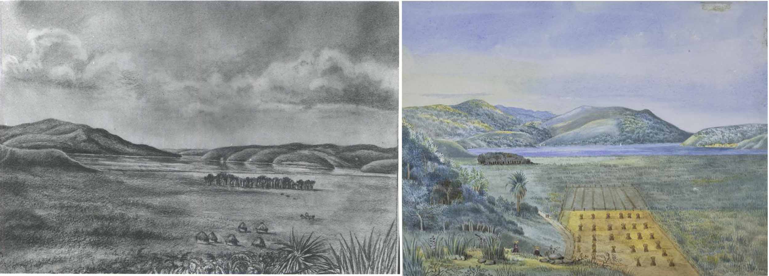
Figure 1. Left: sketch by Catherine Valpy, 1849 (Hocken Collections, Uare Taoka o Hākena, University of Otago, ‘Valpy, C.H.E., Dunedin Harbour & Andersons Bay 1849’. Painting in OESM Collection). Right: sketch by Ellen Valpy, 1850 (Hocken Collections, Uare Taoka o Hākena, University of Otago. Jeffreys, Ellen Penelope, 1827-1904 (née Valpy), Dunedin 1850. View taken from Forbury Hill above Allandale, 1850, Accession Number 7,764).
My bet is that the relatively even-aged, branchless trunks of the canopy trees are mostly kahikatea, and possibly also rimu. In the 1850 image, Ellen Valpy shows the forest canopy decreasing distinctly towards the harbour – probably the result of near-constant wind.
These intriguing images came onto my radar in 2022, when historian Dr Stephen Clarke posted one on his Twitter account. I was astonished, as I’d had no idea any forest had grown on the South Dunedin lowlands. But where, exactly, had it been?
At first glance, I thought the ridge on the left of the images was Bell Hill, pre its demolition. Stephen, formerly from Caversham, corrected me – it’s the ridge on which the Southern Cemetery is now located. Bell Hill is in the background. Anyway, so began a bit of a personal quest to try to locate that forest more precisely.
Ellen’s and Catherine’s image are from slightly different view points. Catherine’s 1849 image looks straight up the Harbour and there is a view into Andersons Bay. The earliest buildings of Dunedin are out of sight behind Cemetery Hill. The patch of forest appears a little to the right of image-centre (between the Harbour and Andersons Bay). The image has no fences, or clear roadways, but a straight line change of tone indicates what might be agricultural clearing. What appear to be conical-topped haystacks are in the near lowlands, flax and a cabbage tree are on the edge of higher land in the immediate foreground.
Ellen’s 1850 viewpoint was a little more to the southeast than 1849 (Hocken Collections, Uare Taoka o Hākena, University of Otago, label it as being ‘from Forbury Hill above Allandale’). It looks towards Mount Cargill. The view up the Harbour is obscured by Burns Point. Now a few of the buildings in original core of Dunedin are visible (in the northern Exchange, at the base of Bell Hill, before it was mostly demolished). Some cottages are also in the distance, by what is now Logan Park. As well as Cemetery Hill, another ridge is in the near foreground, presumably a slope of Forbury Hill. It has low trees, flax, and a cabbage tree. The patch of forest is now more distant, left of centre and just obscuring the lowermost point of Cemetery Hill.
On the flat below the ridge where Ellen sketched, two fields have been demarcated by fences. Neat rows of what look (to me) like hay bales (see Note 1), fill the nearest paddock. At the bottom left corner, the fenced margins of the field curve around a roadway, which hugs the bottom edge of the higher ground. Two people can be seen on it.
My take on this is that the surveyed property – a rectangle, ignored topography, and fell across a common thoroughfare. It may have been used by both the owners and people accessing property further south. Rather than following the legal land boundary, practicalities on the ground took precedence, and the fence follows the road here. The Dunedin Suburban Central Crown Grant map (no date, but about 1857) shows a road looping through the middle of Ellen Valpy’s sections. The Valpy’s may have finally rationalised the issue of traffic through their property, as a Notice of the Otago Witness, Issue 375, 5, February 1859, on Page 2, reads:
‘The Surveyed Line of Road leading from Caversham to the Sands having been opened and fenced off, the road hitherto used and passing through the Forbury Ground has been closed. Any one found on any portion of this property after this notice will be prosecuted for trespass. The Forbury, 21st January, 1859.’
They may have compromised by simply corralling traffic to the edge of the ridge with that fence. In any case, that curved road in Ellen’s image evolved into what is now Forbury Road. There is a problem though. One might hope that the fence lines would equate with the surveyed section boundaries, which would mean the curved road truncates the corners of surveyed Blocks VII, Sections 50 and 51. Alas, the fence lines in Ellen’s image ‘point’ towards Mt Cargill, whereas the surveyed sections ‘point’ towards Andersons Bay. No idea what is going on there.
A third sketch by Catherine shows Forbury Farm, apparently from what is now Valpy Street (University of Otago Hocken Collections Copy negative number c/neg8577 Scan number S0058). The Hocken date it as 1857, and as 1850 in Toitu Otago Settlers Museum ‘Curator’s Corner No 13, on YouTube).
It looks in the opposite direction to the two images with the patch of bush. This time the view is from the paddock, a few metres from that distinctively curved fence, and looks back towards a cluster of buildings, which sit on the lower slopes of a ridge. Near the southern margin of the field, there are more of the ‘haystack’ objects. A track leads directly to the top, and is probably the path that is called ‘Jacobs Ladder’ today (which is located on what was Valpy land). It’s highly likely that Catherine made her other sketches at the top of that ridge, above her home (See Note 2).
I walked up ‘Jacobs Ladder’ hoping to line up the sisters’ images with today’s topography. That didn’t work. For some strange reason, nice viewpoints tend to have houses all over them today, and there wasn’t anywhere I could seem to put myself in the Valpys’ shoes, or even get a decent, unobstructed view.
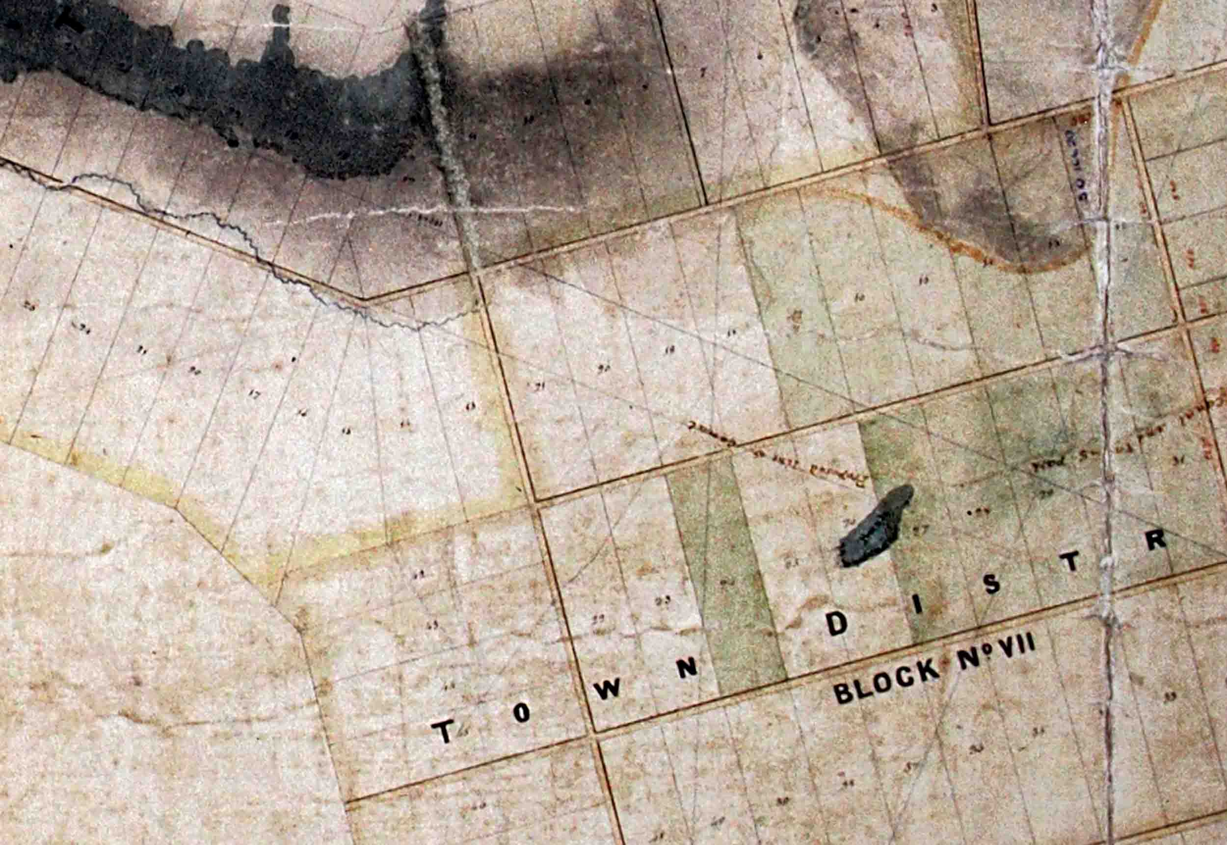
So maybe I could use computer graphics to figure it out? It was while I was messing around with that approach, that I found Ian Dougherty’s 2017 book ‘Dunedin: Founding a New World City’ (Saddle Hill Press, Dunedin). In it, on page 21, was a map that I’d never seen before. The map is ‘Otago Land District SO 6’ (with three sheets) and was drawn by Charles Kettle in 1847 – the year before the first immigrant boats arrived.
His precise map shows large areas of green, presumably bush, near what was to become the centre of Dunedin, and in the Leith Valley area. However, and this blew me away – it also shows one distinct little green patch, of about 175 x 66 m, on the flats of South Dunedin (see the featured image). Could this be that patch of bush in the sisters’ sketches?
Figure 2. The outline of ‘South Dunedin Bush’ (my name!) taken from Kettle’s 1847 map, ‘Otago Land District SO 6’, and overlain on an ESRI street map of Dunedin.
Using a GIS system, I could precisely place Kettle’s little patch of green. It’s just to the east of Bathgate Park, and between Hillside and Macandrew Road (Figure 2). I could then digitally ‘grow’ some trees there, and then, unhindered by real houses, move around the ridges above South Dunedin until I got more or less the same views the Valpys had. The 1849 view is from somewhere about the Kew Reserve playground and probably looks over part of the Valpys’ Caversham property (Figure 3). The 1850 view is from close to Jacob’s Ladder (Figure 4). The little patch of green on Kettle’s map is clearly the patch of bush that the sisters included in their sketches.
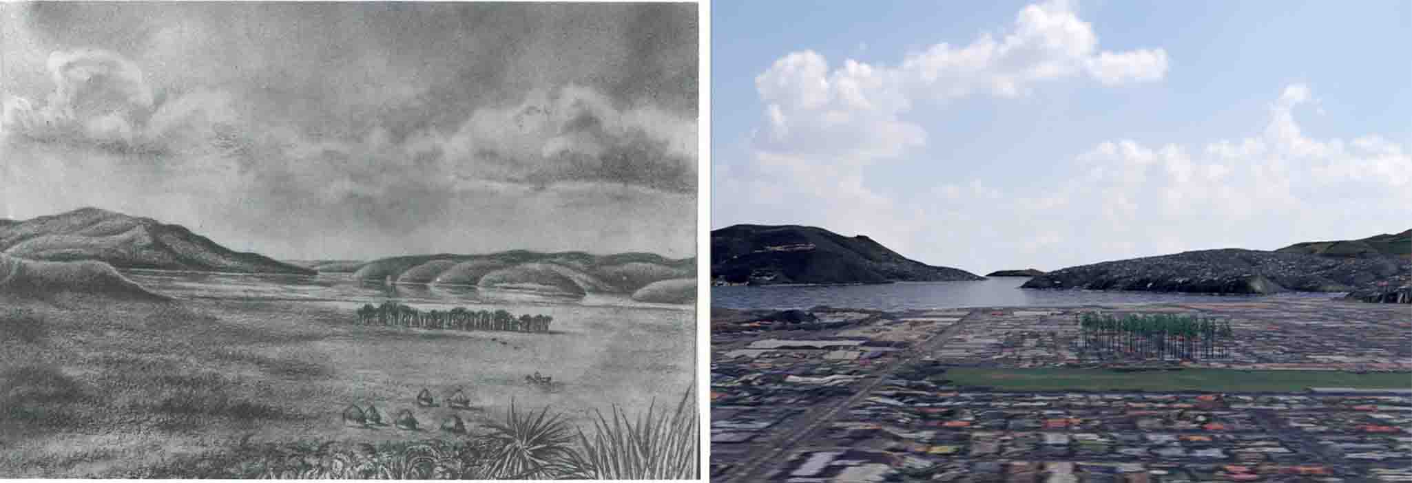
Figure 3. Left: Caroline Valpy’s 1849 image (Hocken Collections, Uare Taoka o Hākena, University of Otago, ‘Valpy, C.H.E., Dunedin Harbour & Andersons Bay 1849’). Right: Author’s digital approximation of the scene, with digital trees placed in the position indicated on Kettle’s 1847 map (‘Otago Land District SO 6’).
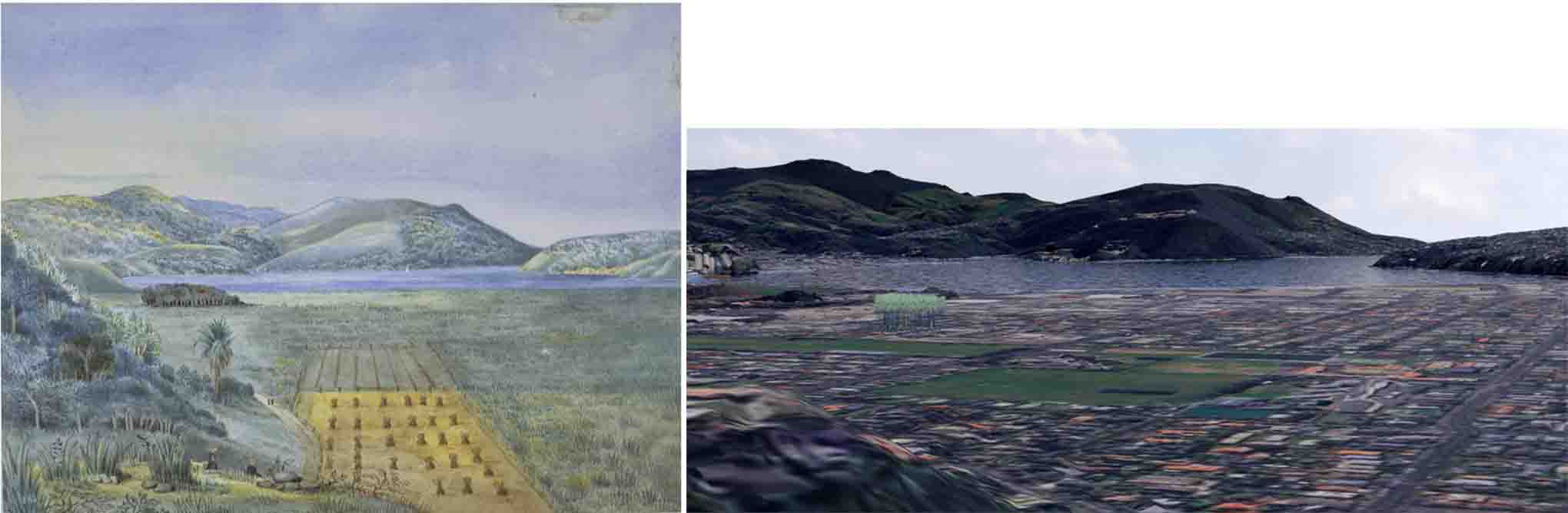
Figure 4. Left: Caroline Valpy’s 1850 image (Hocken Collections, Uare Taoka o Hākena, University of Otago, Jeffreys, Ellen Penelope, 1827-1904 (née Valpy), Dunedin 1850. View taken from Forbury Hill above Allandale, 1850, 7,764 ). Right: Author’s digital approximation of the scene, with digital trees placed in the position indicated on Kettle’s 1847 map (‘Otago Land District SO 6’).
What happened to it? The ‘South Dunedin Bush’ seems to show up in a few later images (Figure 5). An 1866 photo of the Otago Benevolent Institution (now in the Hocken Collections) shows a part of the bush on the far right.
It then appears in an 1869 sketch (‘Swampy flat land, South Dunedin. 1869 South Dunedin.’, ourheritage.ac.nz | OUR Heritage, accessed March 12, 2024, https://otago.ourheritage.ac.nz/items/show/4644) made by The Rev. Thos Litchfield Stanley, from, I guess, somewhere around Walter Street, near the Southern Cemetery. It looks towards Cargill’s Castle. The Dunedin Benevolent Institution Home is marked on the far right of the image. This stood at the corner of the Main South Road and what was then Alexandra Street – now Eastbourne Street. The long, straight road going past the bush is probably Burns Street – Bradshaw Road (or even Alexandra Street).
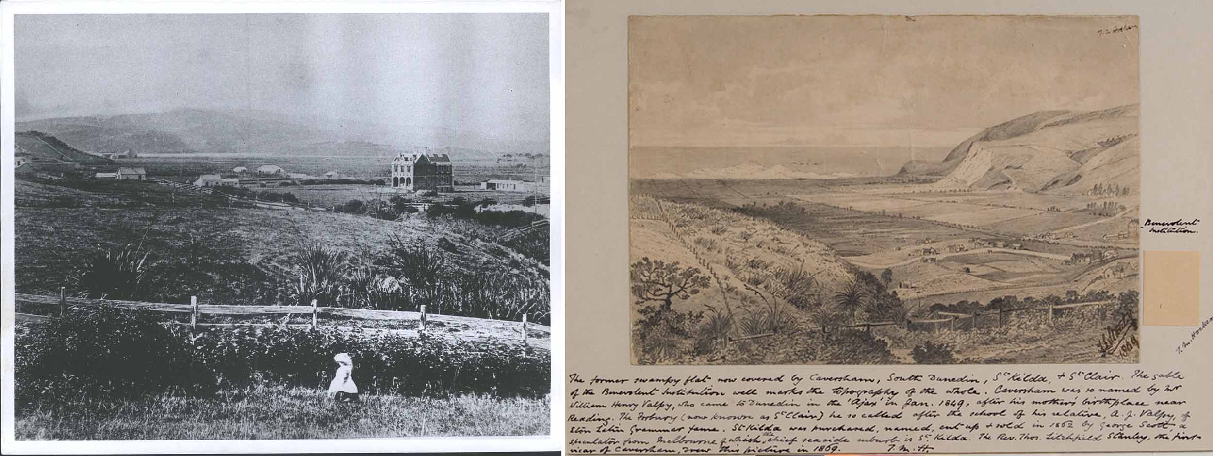
Figure 5. Images including ‘South Dunedin Bush’ in 1866 and 1869. Left: an 1866 photograph shows a few trees just to the right of the Old Peoples House (Talboys) (‘CAVERSHAM: Old Peoples House (Talboys) (1866). Hocken Digital Collections, accessed 25/11/2024, https://hocken.recollect.co.nz/nodes/view/10632’). Right: sketch by The Rev. Thos Litchfield Stanley in 1869. ‘South Dunedin Bush’ is visible just over the ridge-line on the left (‘Swampy flat land, South Dunedin. 1869 South Dunedin. ourheritage.ac.nz | OUR Heritage, accessed March 12, 2024, https://otago.ourheritage.ac.nz/items/show/4644’) made by The Rev. Thos Litchfield Stanley’)
Stanley’s sketch shows the South Dunedin bush still existed twenty years after Ellen and Catherine Valpy first recorded it, although the canopy is by now very broken up. I suspect that by 1869, most of the large trees had been milled out of it. In a degraded state, it probably wasn’t long before it was totally cleared and urbanised.
Thanks Ellen and Catherine Valpy – if you hadn’t taken the care to show it in your sketches, ‘South Dunedin Bush’ would likely have been forgotten…
Note 1. I realise there are other interpretations, and given the widespread understanding that most of the South Dunedin area was a big wetland (known as ‘The Swamp’) it might sound a bit odd to suggest these objects are haybales and haystacks. But Catherine Valpy’s 1849 image shows objects with a cylindrical base and a conical top. Ellen’s 1850 image is coloured, and shows a field which is yellow (in contrast to the surrounding green) in which there seem to be bundles of the dry material. This looks like a field that has been mown, left to dry, then the dry vegetation collected. I doubt this was flax (though stand to be corrected), and think it’s more likely that the Valpys chose well for good farmland. This may have been a fringe of good, well-drained soil, along the base of the ridge, on which some sort of long grass could be grown.
Note 2. Old land survey maps show where Valpy land was. On the November 1859 ‘Crown Grant Index Record Map’, there are several sections belonging to William Henry Valpy and Caroline Valpy in St Clair. An adjoining, but undated, map, ‘Crown Grant Index Record Map, Suburban Central’ shows more adjoining sections belonging to Caroline Valpy and William Henry Valpy. These maps show where Forbury Farm (or ‘The Forbury’) was. There are also two sections in Caversham, belonging to William Henry Valpy. William Henry Valpy senior had passed away in 1852, so presumably these are blocks which had been passed to his son William. Perhaps other Valpy sections had been sold off by 1859 too.
Acknowledgments
Thanks to Historian Dr Stephen Clarke, for his 2022 Twitter post of one of Valpy’s images, which started the whole thing off, and for sending me the 1866 photo of the Benevolent Institution, that also shows it, and for further help with the post since. Dr Clarke’s Twitter/X posts can be seen here.
Thanks so much to Ian Dougherty, for letting me copy his slides of Kettle’s 1847 map (Otago Land District SO 6), and for putting me right on who made the Valpy images featured here (it was the daughters, not their mother, that I’d somehow concluded). You can check out other Saddle Hill Press books Ian Dougherty here.
Thanks to Alison Midwinter of LINZ, for her help in tracking down where Kettle’s map is now stored (in Christchurch), to Shannon McColley of LINZ for putting me in touch with Alison, to Andrew Crake of Archives Dunedin, for confirming that Kettle’s map wasn’t there, and to Nick Austin, at the Hocken Collections | Uare Taoka o Hākena, for help with the status of the images I’ve used.
.