
When a forest is dead, but somehow still there – either as bleached stumps, and felled, and possibly burnt trunks, I call it a ghost-forest. There were vast areas of ghost-forest (or ‘ghost-bush’ if you like) throughout New Zealand in the 19th century (see Envirohistory NZ’s post: ‘Scorched forest farm – Wildbore cache no.7‘ for a good photo of such ghost-forest).
At that same time a ‘Russian scare’ had taken-hold in New Zealand. To plan coastal defences, a very detailed set of Military Topographical maps of the Dunedin area was made by the surveyor W.T. Neill (see Anthony Hamel’s website). He completed 29 numbered sheets (plus some extra), mostly dated to 1901 (Sheet No. 25 – Blocks VII and VIII Dunedin and East Taieri District – is 1907). The maps “were the first coloured topographical maps to be published by the Lands and Survey Department” (Archway-style Collections Search). They give an unprecedented view of the Dunedin surrounds at the turn of the century.
I geo-referenced these sheets onto the current LINZ Topo50 series. This requires finding points on Neill’s maps, like points on the coastline, hill summits, or bends in the road, and finding the matching spot on the modern maps. The GIS system (QGIS in my case) can then scale and rotate the old map – and pretty much everything lines up perfectly.
The area Neill mapped extends to the eastern flanks of Flagstaff and Swampy, north to near Karitane, and south to the Taieri River. The level of detail is such that individual buildings are marked, and typically with the occupant’s names. There is a ‘family-history’ gold mine in these maps! In addition to roads and the railway line, ‘bridle tracks’ are marked, even some ‘tramways’ (I imagine these are ‘bush tramways’, for timber or flax removal). Wetlands are indicated – by the traditional flax-like symbol, very much like the one used on the current topo maps. Intriguingly, above Long Beach, Murdering Beach, Kaikais Beach, to Spit Beach, an ‘Old Native track’ is marked.
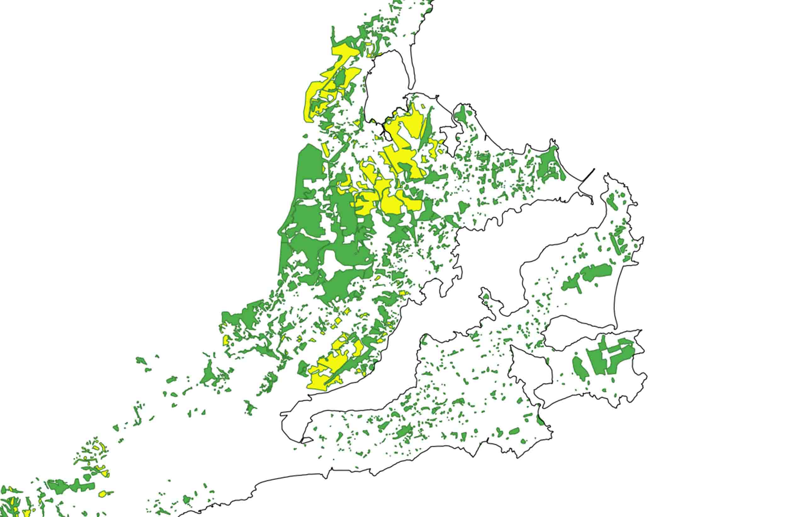
The extent of bush (green) and likely ‘ghost-forest’ (yellow) in the Dunedin area in 1901-1907. The abrupt ending of bush to the west indicates the extent of Neill’s mapping – bush did extend farther westwards. Digitised by Mike Pole from W.T. Neill’s ‘Military Topographical Plans’, made available by Archives New Zealand Te Rua Mahara o te Kāwanatanga, Wellington.
But what really interests me are the scalloped outlines, filled with green. The overwhelming majority of these areas will indicate ‘bush’ – indigenous forest. Very rarely, Neill includes a descriptor in these simple green areas, like the ‘Bush & Scrub’ and ‘Gorse’, near Brockville. The distinction between ‘bush’ and ‘scrub’ may sound odd to non-New Zealanders, but it emphasises the kiwi use of ‘bush’ for typically tall vegetation.
What is striking are the number of bush patches with edges that line up with property boundaries – usually just a little to one side. These surely represent areas where a settler has cleared their land up to, and often slightly over, their neighbour’s boundary. This activity has trimmed patches of bush into rough polygons all over the area.
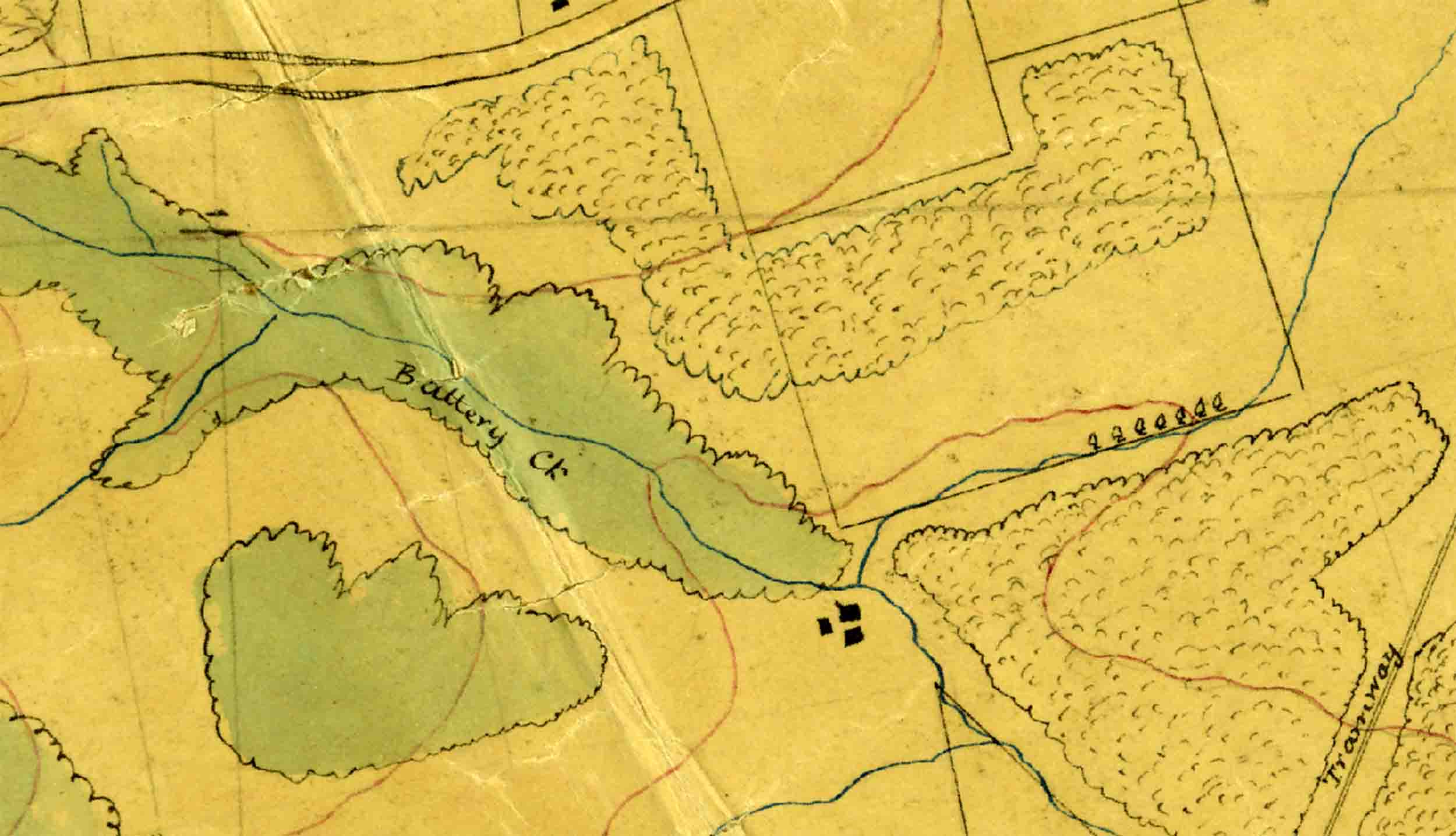
But Neill also employed another style of map symbol – the same scalloped outline, but with an internal ‘stipple’, and uncoloured (on larger areas, the stipple is restricted to the outer 40 m or so). These are often adjacent to the patches of simple green, so are clearly meant to indicate something ‘different’. Just like the simple green areas, the edges of patches with this symbol often line-up with property boundaries as well (see the featured image, which is near the current suburb of Fairfield).
My guess (as far as I know, there is no map-key) is that this symbol represents dead forest – probably extensive areas of felled trees, or stumps, likely fired and bleached – in other words, ghost-forest (some patches of this pattern are specifically labelled – ‘Gorse’ or ‘Manuka Scrub, but they are the exceptions, and I kept the separate in my digitisation). By the time Neill mapped, many of these areas may have had green grass and sheep amongst the forest remains. Distinguishing areas of ‘ghost forest’ may have made practical military defence sense. Botanically, too, they would still have been a wealth of information – the logs could have been identified, and some idea gained of the forest height. But the birds, bats, forest insects, would have gone. And eventually the ghostly presence faded, to grassland.
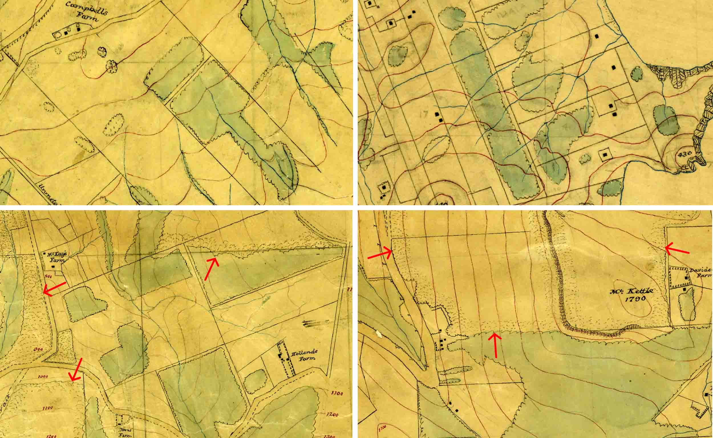
Four images from Neill’s maps (the buildings and roads give a general idea of scale).
Top left: Orokonui Ck-Mopanui. Bush areas (green) trimmed to property lines. Cropped from R22756747, Sheet No. 3 – Military Topographical Plan – Block I North Harbour and Blueskin District – W.T. Neill, Surveyor (1901). Archives New Zealand Te Rua Mahara o te Kāwanatanga, Wellington. (CC BY 2.0).
Top right: Otago Peninsula. Bush areas (green) trimmed to property lines. Cropped from R23188990, Sheet No. 20, Military Topographical Plan – Native Reserve Otago Heads – W.T. Neill, Surveyor (1901). Archives New Zealand Te Rua Mahara o te Kāwanatanga, Wellington. (CC BY 2.0).
Bottom left: Mopanui. Bush areas (green) trimmed to property lines, and arrows indicate the patches of adjacent ‘ghost’ forest with stipple pattern (uncoloured) around the outside. Cropped from R22756747, Sheet No. 3 – Military Topographical Plan – Block I North Harbour and Blueskin District – W.T. Neill, Surveyor (1901). Archives New Zealand Te Rua Mahara o te Kāwanatanga, Wellington. (CC BY 2.0).
Bottom right: Mount Kettle. Bush areas (green) trimmed to property lines, and arrows indicate the patches of adjacent ‘ghost’ forest with stipple pattern (uncoloured) around the outside. Cropped from R23190733, Sheet No. 7 – Military Topographical Plan – Block VII & XII North Harbour and Blueskin District – W.T. Neill, Surveyor (1901). Archives New Zealand Te Rua Mahara o te Kāwanatanga, Wellington. (CC BY 2.0).
The big areas of ‘ghost forest’ in 1901 seem to have been in the Blueskin Bay catchment (i.e. around Waitati) and on Signal Hill. ‘Ground-truthing’ this interpretation of the symbol, will take a bit more work. The best old photos of the key areas don’t have the best detail in the distant areas.
On a GIS system, it’s now possible to flick back and forwards between 1901 and the present. From Neill’s map, we can see where bush today was also existing in 1901, and thus stands some chnace of being an original remnant. Likewise, any ‘bush’ indicated on the modern topo maps, but which is not there on the 1901 map – must be regrowth.
There is a heap to learn from these old maps, and we have W.T. Neill to thank, for capturing these ghosts, before they finally faded ….
Acknowledgments
Many thanks to Jonathan West for getting Neill’s military maps onto my radar. Jonathan’s book, ‘The Face of Nature: An environmental history of the Otago Peninsula’, won the 2018 J. M. Sherrard Award for New Zealand local and regional history.
A very useful link:
Archway-style Collections Search (The ‘unofficial gateway to Archives NZ’): Link to W T Neill’s Military Topographical Maps.