
Green Island Bush is a prime example of a large patch of New Zealand indigenous forest that was essentially annihilated in the late nineteenth century.
It lay between today’s Green Island suburb, on Dunedin’s Southern Motorway, and the coast. Today the area is mainly farmland. Its original extent is shown partly on Charles Kettle’s 1849 ‘Map of the Suburban Lands in the Settlement of Otakou’ (R698468), and the complete outline is marked on the 1859 ‘Crown Grant West’ map (Kettle’s boundary is essentially the same). From east to west it was about 2.5 km, and north to south about 2.3 km.
A little over a decade later, Green Island Bush was probably a hive of settler activity. At the same time landowners were clearing the indigenous ‘bush’ and replace it with exotic grassland and trees, the Otago Acclimatisation Society (operating by 1864, West, 2017) was already unleashing exotic animals on the scene. The March 25, 1871 ‘Otago Witness, News of the Week’ reported:
“Last week a few of the Acclimatisation Society’s birds were seen and heard on several occasions in Green Island bush. On Sunday, a settler’s children who are well conversant with the notes of native birds rushed into the house with great glee, directing their parents’ attention to ‘a gran’ whistler on the big totara.’ From the description, it mast have been either a thrush or a blackbird whose carolling so delighted the precocious youngsters.”
We learn that thrush, or blackbirds were a novelty – and their song something very special. We also learn that this farm still had a “big totara” (Podocarpus, I wonder if it’s still around?).
In a sort of macabre turn, introduced animals were behind the demise of a six year old boy, John Hoffy Dee, from Green Island Bush. The report of the Inquest is on p. 44 of the Otago Witness, 12 April 1900. He had gone missing from his home sometime of a Tuesday – and on the Thursday, “the little fellow was found in a rabbit warren in the sandhills. He was about 6ft from the mouth of the hole, his head looking outwards”.
Then:
“Witness and others started to pull away the sand from in, front -of him, below his chin, but the sand kept running down from behind him, from a small hole leading to the surface on the top of the hill. This hole gradually enlarged, and finally the front piece came down on top of him. They set to clear that away, and at last succeeded in getting the boy out. They, must have been 10 or 15 minutes in digging him out. When they found him. he was” covered with sand with the exception of his head and the aims from the elbows. Dr Will arrived about three-quarters of an hour later – but the boy gradually sank, and died at 3 o’clock on Friday morning. The boy must have been rabbiting and followed a rabbit into the hole. It was the usual way for the boys about there to go into a hole feet first till they felt the rabbit with their feet, and? then they would pull it out between their feet”.
‘Dr Will’ stated that “about an hour” after he visited “the boy recovered to a certain extent”, but the irritation to his windpipe and lungs from sand inhalation, plus around two days of exposure, eventually overwhelmed poor John.
Don’t burrow into sand kids….
By the time the 1901 ‘Military Topographical Map Sheet number 29 of the ‘Green Island Bush and Part Ocean Beach Dist’ was constructed, Green Island Bush itself has essentially ceased to exist. The blackbirds, thrushes and rabbits, will have no doubt been more numerous.
A ‘Green Island Bush Road’ is marked on that map. – this is now Blackhead Road. The name Green Island Bush Road now refers to what was an un-named road on the Military map (once the Bush was gone, were people no longer sure which one it was?!).
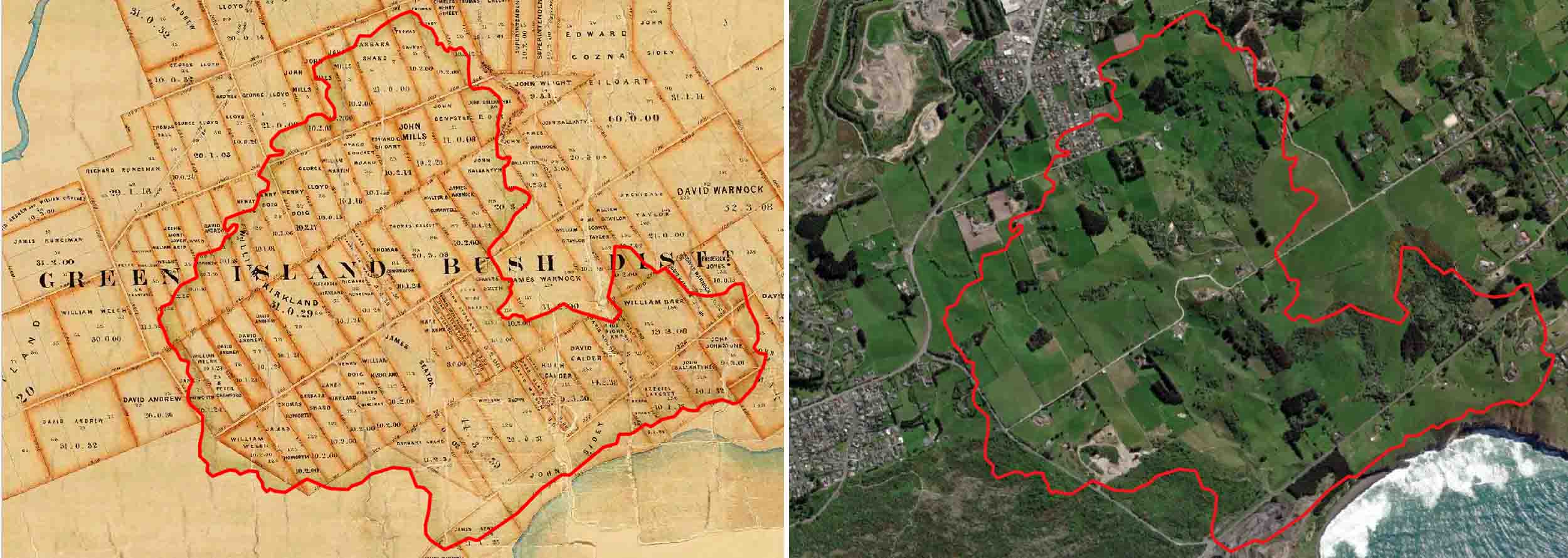
Left: Green Island Bush, outline in red, overlain on the Crown Grant Index Record Map, 1859 (R10302766: Archives New Zealand/Te Rua Mahara o te Kāwanatanga, Dunedin Regional Office.). Right: the same red outline of Green Island Bush overlain onto ESRI Satellite imagery.
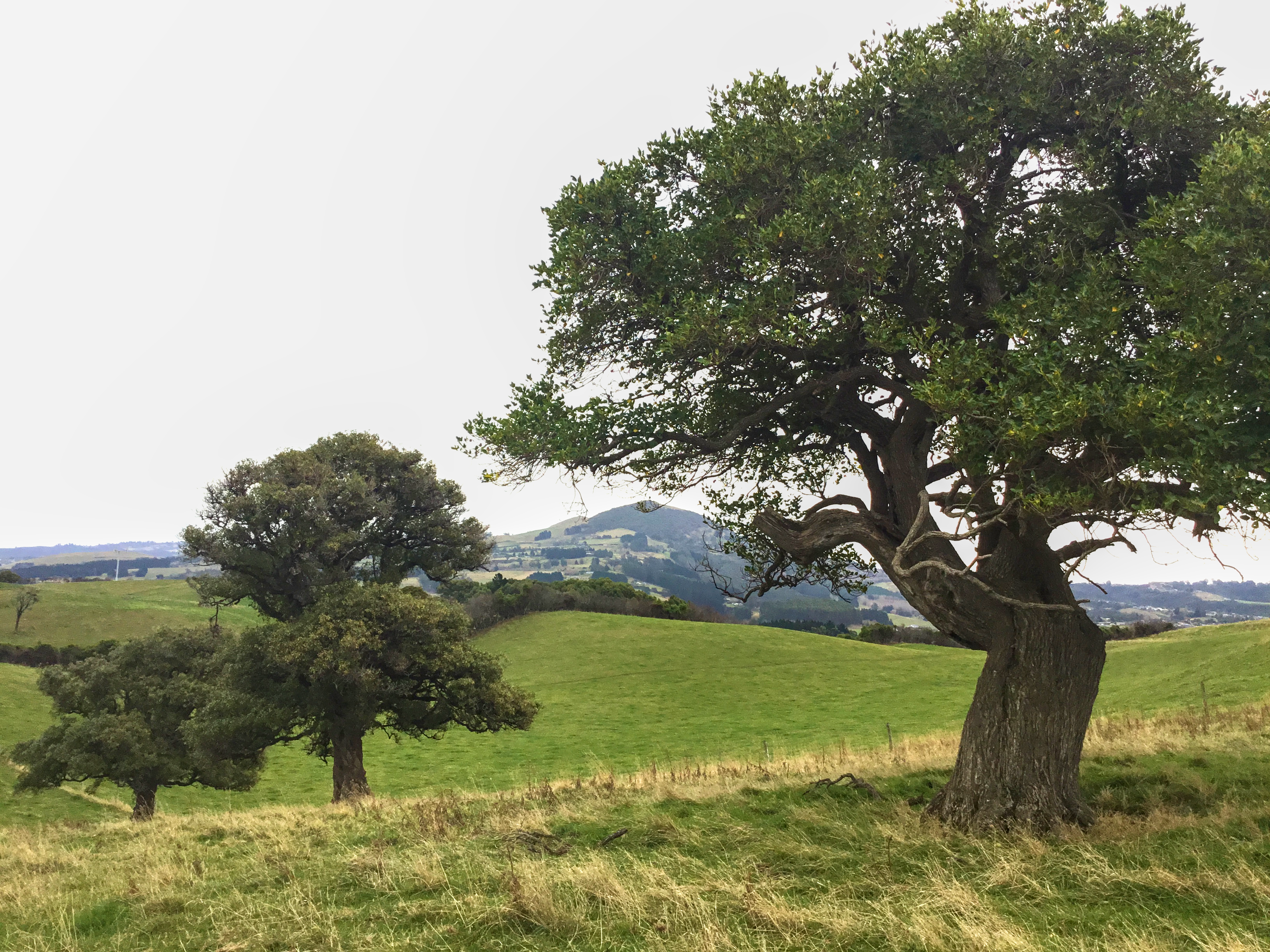
The current 1:50,000 LINZ topo map shows several patches of solid green (in theory ‘native forest’, but in reality, sometimes including ‘scrub’) within the old boundary of Green Island Bush. These compare well with a canopy of trees on ESRI satellite imagery, and at least some of these appear to be of indigenous trees. However, comparison with the extremely detailed 1901 Military Topographic Map suggests that many of these patches may in fact be regrowth since that time. Thus today, genuine Green Island Bush remains only as a few very small remnants, but some of the old trees, isolated in farmland, are apparently survivors from the original canopy.
In 1979 the botanist Peter Johnson reported on one of the remaining patches – a tiny sliver at the eastern end of the ‘Green Island Recreation Reserve’ (the current Island Park Recreation Reserve). He described it as an example of the ‘now rare’ “ngaio-dominated coastal forest”. It was “a narrow fringe, 10-30 m wide”, with dominated by Ngaio [Myoporum laetum] “growing as quite upright trees to 10 to 12 m in height. Mahoe [Melicytus ramiflorus] is also common, with a few trees of narrow-leaved lacebark [Hoheria angustifolia], kowhai [Sophora microphylla], Hall’s totara [Podocarpus laetus], kohuhu [Pittosporum tenuifolium], lancewood [Pseudopanax, presumably P. crassifolious], broadleaf [Grisellinia littoralis] and miro (one tree) [Prumnopitys ferruginea].” He went on to comment that:
“Coastal forest of similar composition, although now rare in Otago, does survive in larger stands at Goodwood and Heyward Point (both Scenic Reserves) and at Taiaroa Bush and Saddle Hill (not reserved, severely grazed). ‘What this bit of forest does offer though, is a seed source (the only one) for reafforestation of the lupin and elderberry scrub that covers much of the reserve.”
Green Island Bush is a fairly good example of of New Zealand bush being “seen as another marker of land productivity” (Pawson and Holland, 2005). Identified as such, it was subdivided into a matrix of small-holdings, and cleared. We are grateful for these few relicts, preserved by farmers on their land, to give us the barest idea of what Green Island Bush was made of.
References
Johnson, P.N. 1979. Green Island Recreation Reserve – Botanical notes. Botany Division, DSIR, Report. Dunedin.
West, J. 2017. The Face of Nature: an environmental history of the Otago Peninsula. Otago University Press, Dunedin, New Zealand.
Pawson, E. and Holland, P. 2005. Landscape. Lowland Canterbury landscapes in the making. New Zealand Geographer, 61: 167–175.