
Leads to New Zealand’s ‘lost forests’ turn up in all sorts of places. I was in the Dunedin Public Library when I came across the wonderful book ‘Under the Eye of the Saddle Hill Taniwha’ by Sharron Bray, Graeme Thomas, and Victor MacGill (1998).
Their book reproduces an 1847 map of the Taieri (preferred spelling now Taiari) by Charles Kettle, now in the Hocken Library, showing a patch of forest, identified by the authors as ‘Taieri Bush’. There’s also the author’s adaptation of an 1857 map, showing ‘Taieri Bush’, as well as an 1856 water colour painting by John Buchanan, of ‘Taieri Bush and Saddle Hill’ (now in the Alexander Turnbull Library), and a later photograph where “Taieri Bush on the site of Bush Road can be seen beyond the railway station”.
It all piqued my interest. There is certainly no forest there today.
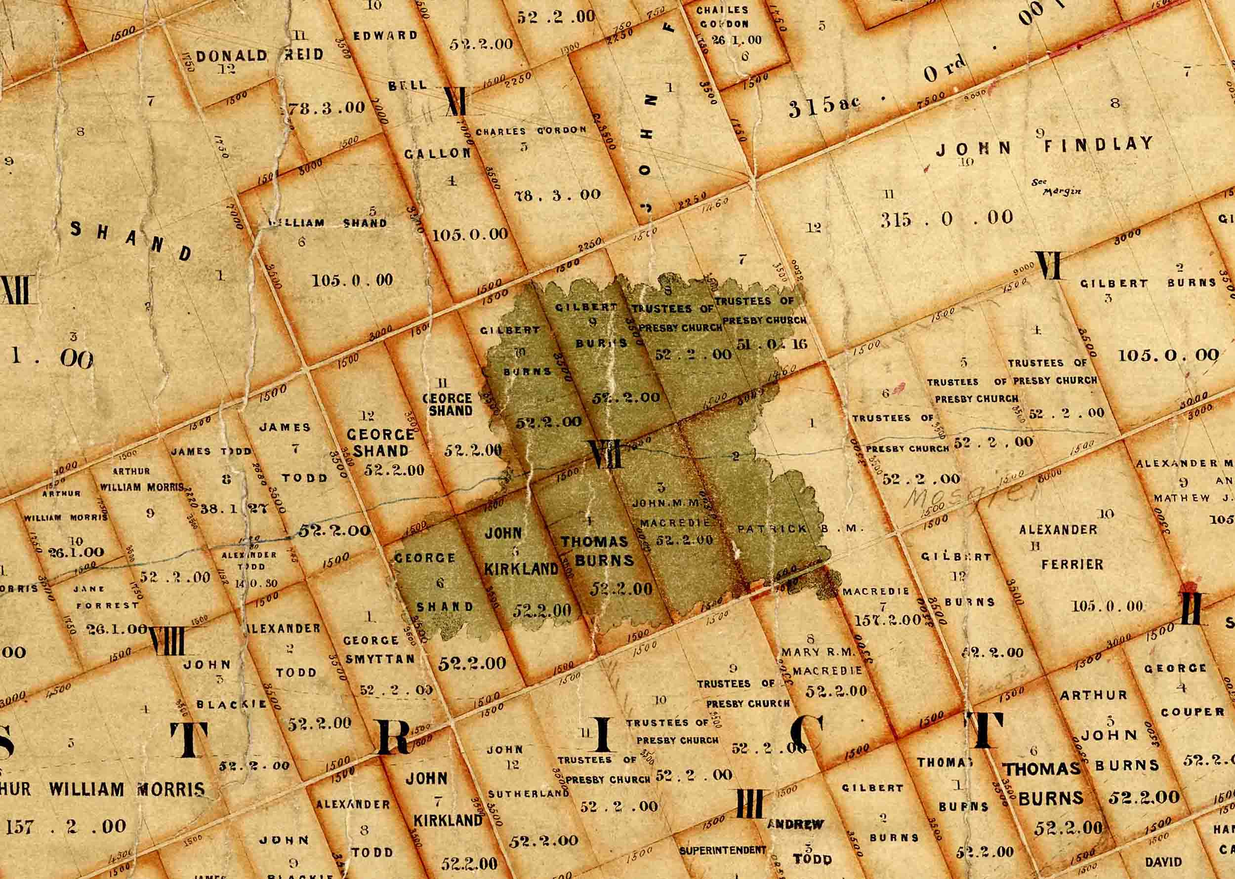
Kettle’s map has now been digitised, and is on the Archives New Zealand website (R698465). But further search on the Archives website turned up ‘Crown Grant Index Records Map of Taieri and Waihola – ‘Outline constructed October 1859’. This even clearer map shows the various sections that had been surveyed off, and the names of their owners, and the course of the Taieri River. It also has what are clearly patches of forest (‘bush’ in New Zealand parlance), painted green, with a large one about where Mosgiel now stands. I’ve cropped part of that map (‘Crown Grant Index Records Map. Taieri [and Waihola] Survey District. Constructed October 1859’. Archives New Zealand Item R10302830_01. Creative Commons BY 2.0 license) for the ‘featured image’.
The1859 map was an ideal candidate to ‘georeference’ onto the modern LINZ topographic map. This wasn’t immediately straight-forward, as some roads surveyed then are not roads now, various fence lines today don’t match 1859 section boundaries, Mosgiel did not exist then, even as a plan, and Taieri Bush does not exist now.
But starting off with roughly positioning some prominent loops of the Taieri River, and guessing what some hills were, gradually more precise locations – corners of sections, and what are now road intersections fell into place. Eventually, the 1859 map georeferenced very well onto the modern. In other words, the surveying from over 160 years ago, was spot-on.
From there, it was possible to see exactly where Taieri Bush actually lay – it overlapped what is now the north west part of Mosgiel. Taieri Bush was bounded by Dukes Road to the north, Bush Road to the south, and Riccarton and the main road through Mosgiel to west and east. The patch of forest was about 1700 m x 1300 m.
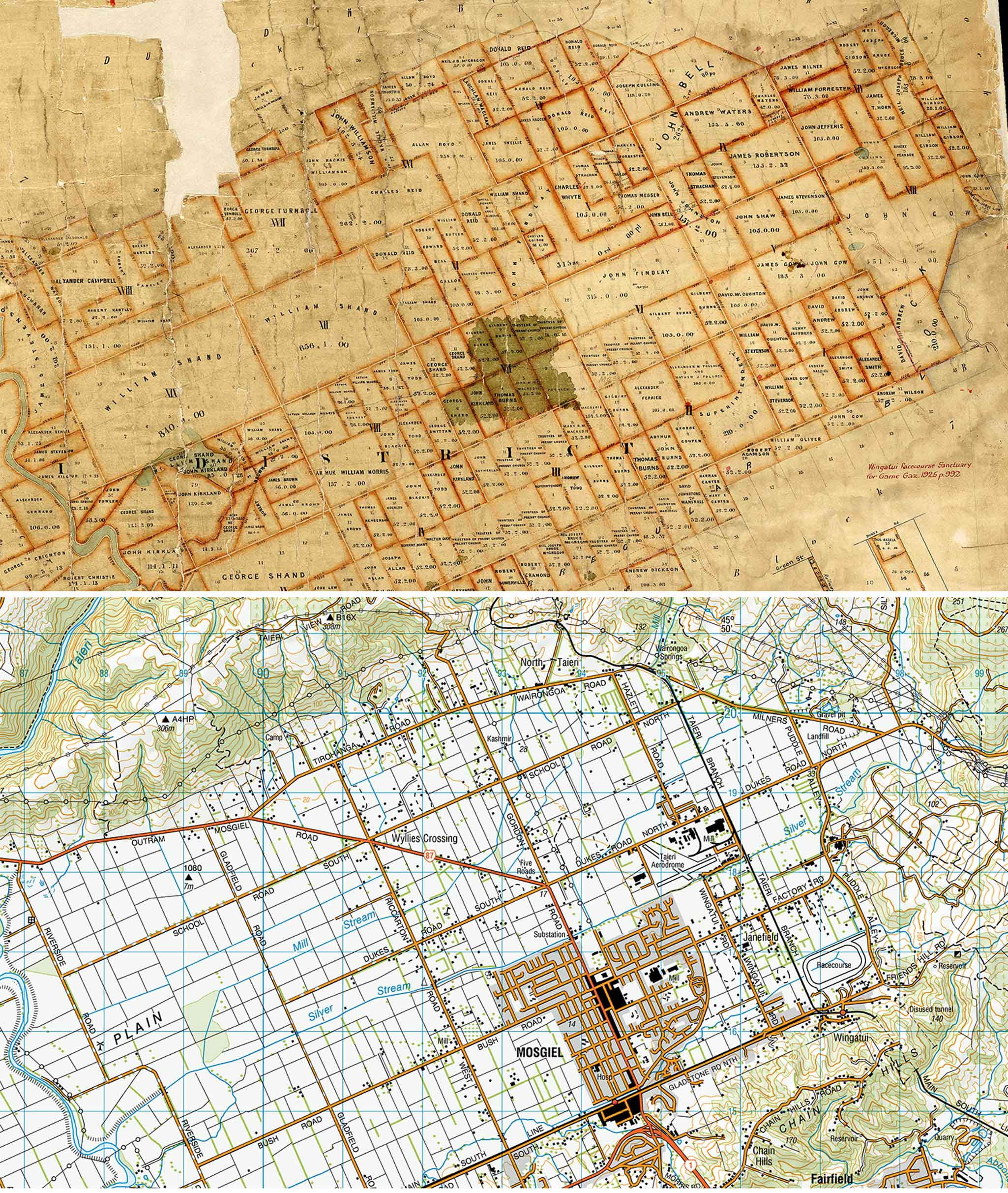
Top: A section of the ‘Crown Grant Index Records Map of Taieri and Waihola – ‘Outline constructed October 1859’ (Archives New Zealand. ID: R10302830. Creative Commons BY 2.0 license). The green patch is Taieri/Taiari Bush. Bottom: The corresponding region of the LINZ 1:50,000 Topo map, after georeferencing.
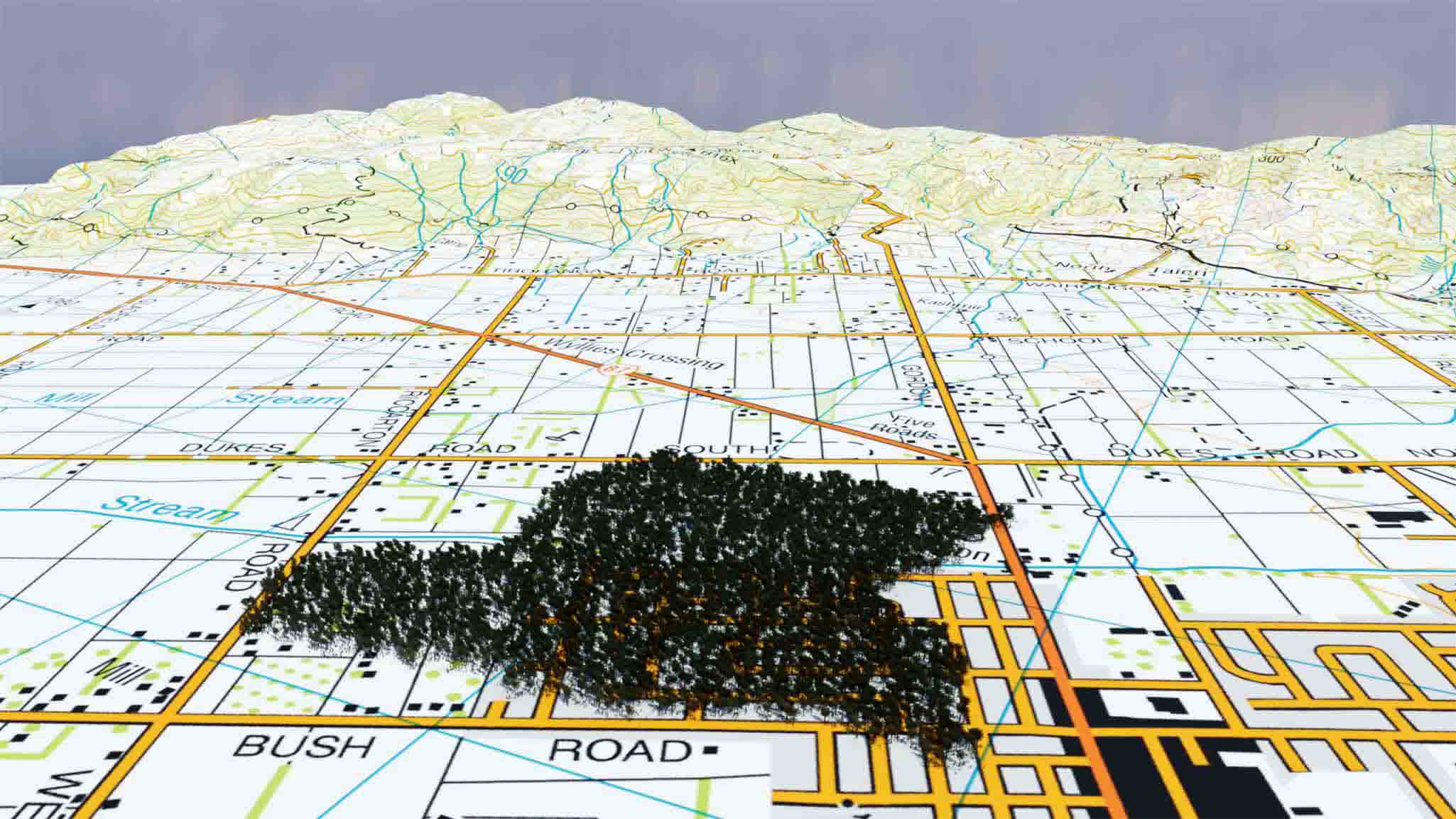
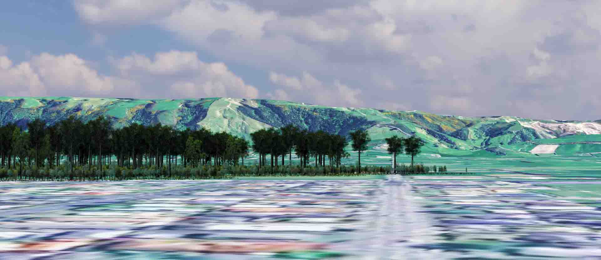
Next step was to recreate the local topography in a 3D programme and create a ‘digital’ Taieri Bush. With that done, it’s possible to see the forest from various angles.
An oblique aerial view of a digitally reconstructed Taieri/Taiari Bush from the southeast, towards Taieri View. I’ve used the LINZ 1:50,000 Topo map as a base, to show the streets. (Image: the Author, Mike Pole)
If you were heading through Mosgiel, along the main road towards Outram (the dark orange road in the upper picture), this is what you would have seen ahead (absent the buildings, of course). The main street passed through the edge of Taieri/Taiari Bush. (Image: the Author, Mike Pole, using Google satellite imagery as a base)
Computer graphics also make it possible to try and ‘line up’ old pictures of the forest. Buchanan’s 1856 image was made from somewhere below where ‘Taieri View’ is now. As well as the main Taieri Bush, it also shows at least four much smaller patches of trees further in the distance. These correspond perfectly to four, of five, patches of forest shown on the 1859 map. They were all about 140 to 180 m long, and a little narrower. They were near what is now State Highway One. In fact, the highway would come to pass directly through the two patches on the far right (south west) of Buchanan’s image, and another one just out of view. I do wonder if this was deliberate! Or perhaps it’s just that the best place to stick a road, also happens to be the best sites for kahikatea. Or, perhaps Maori travelers had planted trees along the trail….
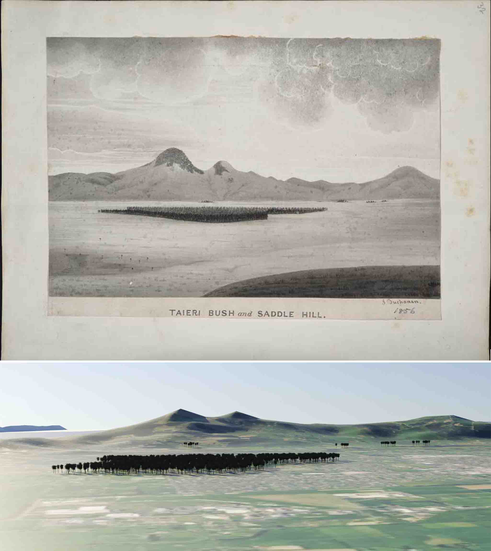
Top: John Buchanan’s ‘Taieri bush and Saddle Hill. 1856’ (National Library of New Zealand, Reference E-207-q-032, surrogate). Bottom: Roughly the same view in a digital landscape. Note the small patches of forest in the background, along the current main Dunedin-Milton road (Using Google satellite imagery as the base. Overall image, the author, Mike Pole)
While Googling on the topic, I came across another image on the Otago University Research Heritage site (https://otago.ourheritage.ac.nz/items/show/4550). This was a painting made by George O’Brien: ‘The Taieri Plains 1867. Taken from the the Upper or Halfway Bush Road leading down to the North Taieri.’ T.M. Hocken has added “No vestige remains of the Big Bush”. When I first read this, I assumed he meant “No vestige” in this image. However, it does appear like a patch of forest is there, in the right place. I can’t quite get my digital landscape to line up with the painting – there may be some vertical exaggeration in it, plus it seems to be taken from a view point somewhat higher than the land surface. But that prominent V on the right looks like the intersection of Milners Road and Dukes Road. If so, the next road to the left would be Bush Road, which appears to pass through the bush, and then there are two more parallel roads Gladstone and the main road, before the edge of the hills. So maybe Hocken meant “no vestige remains now, of the Big (Taieri) Bush, which is visible here”.
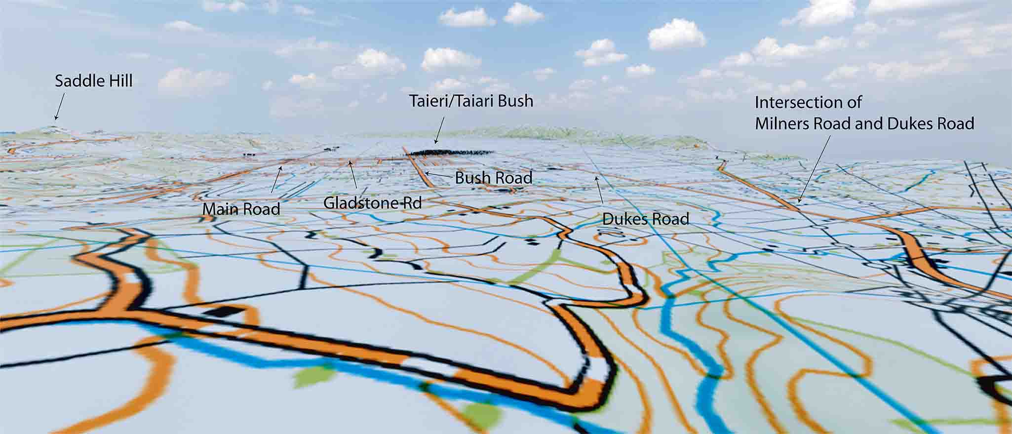
My digital take on George O’Brien’s “The Taieri Plains, 1867. Taken from the the Upper or Halfway Bush Road leading down to the North Taieri.” (see original at https://otago.ourheritage.ac.nz/items/show/4550). This image, the author, Mike Pole, using LINZ 1:50,000 topo map as base.
What exactly was Taieri Bush? The Taieri region is a horst-bounded graben (a down-faulted depression). To the south-east, the higher block that forms the barrier with the coast, had a couple of types of forest in pre-European days. Following Simpson and Thompson (1938) there was likely both ‘Myoporum laetum (ngaio) coastal forest’, as well as ‘rain forest’ with various podocarp conifers scattered through it (Allen, 1979, describes some near Henley) and various scrubland. On the opposing horst, Mount Maungatua had patches of the very different ‘beech’ (Nothofagus) forest (Simpson and Scott-Thompson, 1928; Wardle and Mark, 1956). But on the lower graben block, it was mostly wetland, often dominated by flax (Phormium), or grasses, with scattered cabbage (ti) trees. In among that vegetation, the few little islands of forest, such as Taieri Bush, were likely to have been dominated by kahikatea (Dacrycarpus). This is none left, so this has to be inferred from the odd old comment, and basic ecology. For example, on the map ‘Sketch of the Middle Island of New Zealand. Reduced from original Maori sketch made for Mr Halswell, date about 1841 or 1842‘, the comment ‘Plenty of white pine‘ (kahikatea) is written across the area between the upper Otago Harbour, and the Taieri River. In addition, though the trees in Buchanan’s image are stylised, the general form looks like podocarp conifers.
Kahikatea is often found in wetlands, though they tend to establish in relatively nutrient rich flood silts, rather than organic, peaty soils. In general, the Taieri Plains flood a lot, hence the flax wetland. Taieri Bush, even though on the edge of the slightly higher ground chosen for Mosgiel, still gets inundated – 1870, and 1923 for example (fig 2.2, O’Sullivan et al., 2013).
Is there anything left of Taieri/Taiari Bush? In the sense of any living trees – no. Not a skerrick. But somewhere under a Mosgiel section, there just may be a little peat – which might have some of the leaves and seeds of Taieri Bush trees.
If you find some, let me know…..
Technical Stuff
Georeferencing was carried out with QGIS. The digital landscape was created from LIDAR data from LINZ, using Blender. The trees are ‘billboards’ created from digital plants bought from globeplants.com and spread with GeoScatter (bought).
References
Allen, R.B. 1979. Native Vegetation, Henley, East Otago. Botanical Report. Botany Division, DSIR.
Bray, S., Thomas,G., and MacGill, V. 1998. Under the Eye of the Saddle Hill Taniwha. Maori Place Names and Legends as Viewed From Saddle Hill, Extending From Green Island South to Taieri Mouth and Across to Maungatua, Then North to the Silverpeaks. Ngā Tutukitanga o Taieri, Mosgiel.
O’Sullivan, K., Goldsmith, M., and Palmer, G. 2013. Natural hazards on the Taieri Plains.
Otago Regional Council, Dunedin.
Simpson, G., and Scott-Thompson, J. 1928. On the occurrence of the Silver Southern-Beech (Nothofagus menziesii) in the neighbourhood of Dunedin. Transactions and Proceedings of the Royal Society New Zealand, 59: 326-341.
Simpson, G., and Thomson, J.S. 1938. The Dunedin Sub-district of the South Otago Botanical District. Transactions of the Royal Society of New Zealand, 67: 430–442.
Wardle, P., and Mark, A.F. 1956. Vegetation and Climate in the Dunedin District. Transactions and Proceedings of the Royal Society of New Zealand, 84, 33-44.
3 comments
Very interesting
You put a lot of work into this
Thanks! Yes, mulled over it for months. And, naturally, as soon as I published, I spotted bits where I could improve….
This is a very valuable post.