
Imagine when the first humans arrived in Aotearoa New Zealand, just 700-odd years ago. It was the last habitable place of any size that humans discovered. It was perhaps as close to a ‘paradise’ as you could get. How much of New Zealand was forested on that fateful day? Various clues can help – the pollen record of peat is important– from which it can be inferred that the surrounding area was either thick forest, or perhaps a mixture of forest and non-forest vegetation. Buried logs and tree charcoal appears here and there, and clues like the bones of forest-restricted birds can be useful (e.g. Lavers, 1978, for the North Island kokako). The extent of potential forest, in the absence of major disturbance – like humans (a constant source of fire), can also be modeled. These only give a general view of forest distribution at any one time, but when all are combined, they paint a picture of almost total forest cover over New Zealand (except above the natural tree line, recent volcanic areas and wetlands, and perhaps the very driest parts (McGlone, 1989; Leathwick, 2001).
But shortly after those humans arrived, huge areas of the most vulnerable forest were quickly burnt in an ‘Initial Burning Period (McWethy et al. 2009, 2010). Much of this was likely to be accidental, rather than deliberate for ‘hunting moa’, or creating farmland. A camp-fire in the driest forests, followed by a nor-wester gale, could have had catastrophic consequences. This doesn’t rule out some fires being lit deliberately to clear vegetation (as the ecologist Geoff Rogers noted in a public talk – perhaps to better expose useful rocks) but burning over a far greater area than intended. Perry et al. (2012) sought to “isolate the biophysical predictors that explain forest loss in the pre-historic (i.e. pre-European) period in New Zealand.” They found that climate was the overwhelming predictor, followed by topography. The effect of human presence was much less overall, though was markedly higher in the North Island than the South. They showed this in a map of ‘probabilities’, which I presume could also be interpreted as the rough sequence of burning – starting with the most vulnerable areas (for instance, the Central Otago basins and Canterbury Plains) which may have been mostly deforested within a few years if human arrival.
Forest destruction slowed after that ‘Initial Burning Period’. But those fires probably stimulated the expansion of relatively flammable scrub and low forest – like manuka and kanuka. These would have helped carry subsequent fires into adjacent, slightly less vulnerable forests. Fires would have ‘nibbled’ away at the forest edges over the next few centuries, a process that would have continued until Europeans arrived.
In the early 19th century, Europeans began to arrive with quite a different mind-set. When not regarded as actual valuable resource to mill, forests and wetlands were seen as both indicators of rich soils, and impediments to farming. Thus, a second enormous wave of forest clearance began, leading to the current situation where forests are mainly in the wet and high country, and mostly tussock and shrubs in the dry-lands. This is a kind of new ‘baseline’, although forest clearance continues in New Zealand (Ewers et al., 2006).
But where, exactly, were those forests that were already survivors in late Polynesian times, but were then cleared by early European settlers? Early Europeans produced maps, but the initial focus was, understandably, on the New Zealand coastline. For forest distribution in that very early period of settlement (c. 1800-1850) we can read the narratives of various travelers and we can study paintings and sketches. Maps showing actual forest distribution mostly came later. For example, in Otago/Southland, Kettle’s maps around Dunedin, made immediately before full-scale settlement in 1848, show forest boundaries, but one of the first more regional maps showing forests, was probably Thomson’s 1866 map covering what is now Otago-Southland. Likewise, in Canterbury, the ‘Black Maps of the lower country, show forest boundaries in great detail.
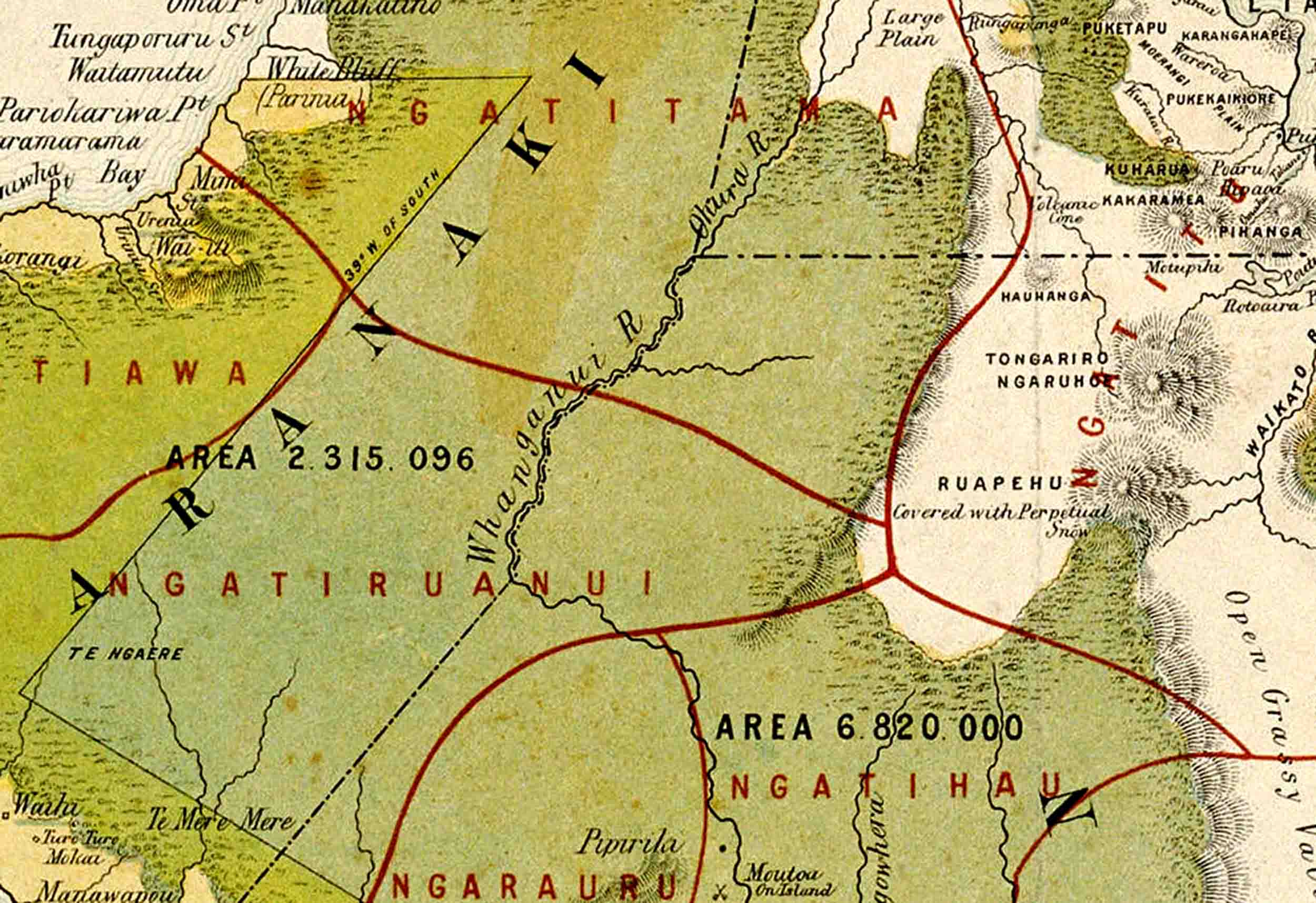
In the North Island the oldest regional maps I am aware of were published by the New Zealand Defence Office in 1869 (date to the Waikato Wars). Two maps show exactly the same forest boundaries (Figure 1, left): ‘Sketch map of the North Island of New Zealand. Shewing approximately the loyal and rebel districts’ and ‘Sketch map of the North Island of New Zealand shewing native tribal boundaries, topographical features, confiscated lands, military and police stations, etc. 1869.’ The maps don’t include Northland, but show many internal details of the rest of the island. A huge tract of forest extends from the Tararuas, through the Taranaki, and then extend as a narrow strip all the way to the mouth of the Waikato. The Raukumara and Coromandel are covered in forests, and various smaller patches are shown, apparently precisely (other sources are the ‘Maori Land Maps’).
However, these maps were created nearly thirty years after the major settlement of Wellington and Auckland (1840) – time enough for there to have already been major forest clearance in these areas. Travelogues, such as by Ernst Dieffenbach (1843) and several paintings show dense forest in the Wellington/Hutt Valley area in the early 1840s (see Rebecca Parmenter ‘Ohariu – Past, Present, and Future‘). But in those 1869 maps – there is nothing. To some extent, this may indicate the limits or inaccuracies of the maps – the Rimutaka Ranges are shown without forest, but its clear from current distribution that large areas of forest had to have survived there. There are also a few tiny patches of relict forest in the Wellington area today, such as Ōtari-Wilton’s Bush, although these will have been too small for those maps. However, the broader message of those 1869 maps is probably clear – the swathe of forest existing at European settlement in the Wellington/Hutt Valley was probably gone by 1869. It’s certainly gone today.
In the interior of the North Island, forest distribution probably changed little, up until pervasive alienation of Maori land, following which, clearance was rapid. Widespread, accurate maps of New Zealand’s contemporary forest cover only really appeared with the first comprehensive Survey maps; NZMS13 (and it’s sometimes not even indicated on these). Completing the full set of maps was a drawn-out process (from around 1899-1939) – and by the time many of these had been completed, huge areas had already been deforested.
Today, there are accurate maps of our remaining indigenous forests (For instance the Forest Service Mapping Series 6). In the South Island, these show extensive forest remaining west of the Main Divide, but scattered patches to the east. In the North Island (Figure 1, right), a discontinuous strip of forest extends along the high country from near Wellington to East Cape. It’s very thin in the south, but impressive tracts cover parts of the Kaimanawa-Kaiweka and the Urewera-Huiarau-Raukumara region. In the west, a large expanse of forest is in the headwaters of the Wanganui. But the broader picture is one of many fragments. Even the larger areas are riddled with cleared corridors – rather than simply reflecting a more detailed map, most of these will be clearings along roads.
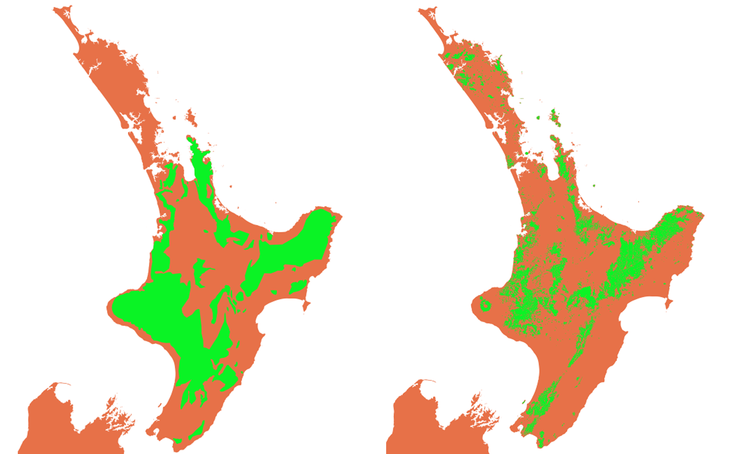
Figure 1. Left. Forest (green) indicated on map by the New Zealand Defence Office (1869) ‘Sketch map of the North Island of New Zealand. Shewing approximately the loyal and rebel districts’, digitised by the author. Right. Approximate current-day forest extent indicated on the New Zealand Forest Mapping Series 6. Image: the author (Mike Pole).
But what was the exact distribution of New Zealand’s forest at European arrival? It was something of a mystery, and wasn’t until 1941, that a New Zealand geographer, Kenneth Cumberland, wrote:
“It is somewhat of a paradox, then, to discover that no botanist has produced a map of this vegetation cover and that few have been concerned with the areal distribution of communities. Yet such a map is indispensable to the type of study attempted here; and an effort has been made, based on the interpretation of leading botanical works, to construct a map of the primitive vegetation of New Zealand before the beginnings of the real onslaught of European colonization in 1840.”
Cumberland (1941) then presented a map – the first estimate of how New Zealand looked in 1840. He wrote that this was based on “leading botanical works … more especially” Cockayne (1927, 1928. I haven’t seen the latest editions of these two books, so I’m not certain what information Cumberland was using).
For the North Island, he shows so much forest that it’s easier to note what wasn’t forested, rather than what was: a generally clear zone extended through the Hawke’s Bay (or Hawke Bay) hinterland, Waikato basin, Masterton, and from the Rotorua thermal area, through the Kaingaroa and down to the Desert Road. You could have walked from Wellington to Manukau Harbour, or from New Plymouth to Cape Turnagain through continuous forest. From the western point of Taranaki to East Cape, a journey would only have been interupted by a short stretch of grassland.
In the South Island, Cumberland, notably, showed forest covering Banks Peninsula, and a modest, discontinuous forest cover along the southern coast between Fiordland, through Invercargill, and on to the Catlins. Cumberland, curiously, shows the Hutt Valley as a narrow clearing within extensive forest – in that sense, it seems show the situation a few years after 1840.
The next attempt to produce a country-wide map of ‘Pre-European vegetation’ was by the “botanist and forester” Lindsay Poole (1966), for the ‘Encyclopaedia of New Zealand’. His map distinguished ‘Podocarp/Mixed Hardwood forest from ‘Beech and Beech/Podocarp Forest’, but showed much more forest in southern New Zealand than Cumberland – a solid strip of forest extending from Fiordland, up to Dunedin, and on to past Moeraki. Extensive forest is indicated on the flanks of some South Island interior ranges. In the North Island, the details are different from Cumberland, but he indicates much the same non-forested zone running down the middle, from the Waiakto, to Hawkes Bay and on to the Wairarapa.
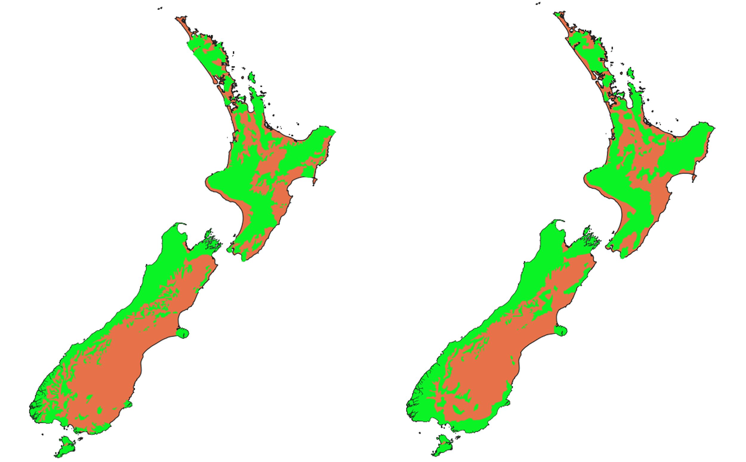
Figure 2. New Zealand forest extent at about 1840, estimated by two specialists (digitised from the originals by the author). Left, Cumberland (1941). Right, Poole (1966). Image: the author (Mike Pole).
A decade later, William Wendelken (1976), another forester, produced a map of 1840 forest cover for the ‘New Zealand Atlas’ (this book, and this map in particular, absolutely fascinated me as a schoolboy). Wendelken’s estimate of forest distribution is broadly similar to Poole’s, but with even more forest in the North Island. It differs in details of the boundaries, which appear more generalised, but his map shows more types of forest, as well as other features, such as ‘swampland’.
After this, several more local maps of New Zealand’s earlier forest distribution were published. In the North Island, these included Taylor and Sutherland (1953) which showed the “Primitive vegetation of North Auckland”, Murton (1968) of the east coast, and Beever (1981) of lower Northland. The next regional map was McGlone’s (1983) “Extent of forest at the time of the first European surveys, approximately 1840-1860 AD”. This was “based primarily” on Holloway (1959) and Wendelken (1976), but with modifications according to Taylor and Sutherland (1953), Johnston (1961), Forrest (1963), Petersen (1965), Murton (1968) and Beever (1981), with the caveat that the “figure may therefore exaggerate the amount of cleared land at the beginning of European settlement.” McGlone’s map shows thin belts of forest around the mountains of the drier parts of the South Island, close to what would ave been the tree-line. More recent significant contributions (books) regarding forest distribution at European arrival were made by Grant (1996) for Hawke’s Bay , and by Knight (2014) for the Manawatu.
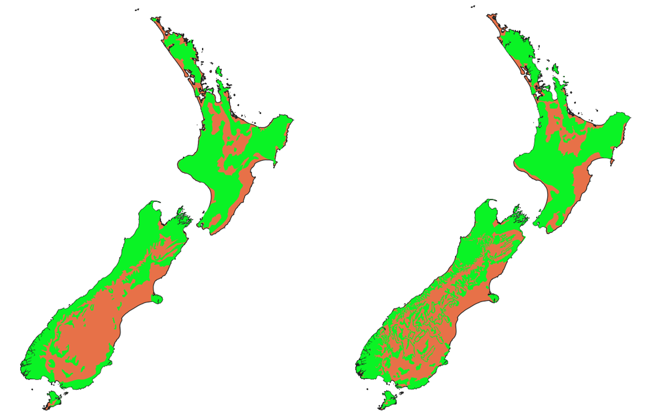
Figure 3. New Zealand forest extent at about 1840, estimated by two specialists (digitised from the originals by the author). Left, Wendelken (1976). Right, McGlone (1983). Image: the author (Mike Pole).
Today, we likely have a reasonable idea of where forest existed in 1840 – even if the justification for parts of those maps is unclear. This situation will only improve, as on-going digitisation of old maps, newspapers, photos and paintings will make sleuthing easier.
But why bother at all? Unlike Polynesian times, 1840 is the first time we have relatively systemic records to deduce accurate forest boundaries. It clearly doesn’t represent “original” forest cover, but it gives us a first clear snapshot of a landscape that was by then, already heavily changed. It’s a kind of ‘stepping stone baseline’. It gets us used to how completely vegetation can be altered, and emphasises that even in 1840, many forests were already survivors. Once extensive tracts of forest have been both reduced – and fragmented, and many small patches of bush have disappeared entirely. Some types of forest have been especially hard-hit. These have implications for conservation, for exaple, isolated, small patches of forest, can be practically useless for some bird species. Most lowland forests (our most ‘Tolkinesque’), and particularly important for many birds, have now gone, resulting in most New Zealanders today, perhaps associating ‘the bush’ with higher country. But also they realise that now is the time to restore forests, to plant new ones, and to create corridors connecting scattered patches. Just the knowledge of where forests used to be, can help energise that mahi. These forest maps can challenge the mental maps New Zealanders have of their country. They emphasise that our current ‘base-line’ is not natural. For some of us, the mental map may be ‘bush is high-country thing’. For others, it may be simply a shock to learn that city/farm/grassland that they grew up in, was once dense bush.
Perhaps most importantly, these maps should also help us think about the value of what we have left.
Notes
I’ve digitised forest extents indicated by the auhors on their maps using QGIS. They won’t be exact copies. For the tree-line details around the Main Divide and Fiordland, rather than the generalisations of the published maps, I’ve mostly used New Zealand Forest Service Mapping Series 6 (FSMS6, primarily compiled by J. Nicholls and D. Franklin, and further field checked by FRI graphics staff, Herbert, 1997). In most cases the forest boundaries will be the same as 1840.
References
Beever, J. 1981. A map of the pre-European vegetation of lower Northland, New Zealand. New Zealand Journal of Botany, 19: 105-110.
Cockayne, L. 1928. The Vegetation of New Zealand (Die Vegetation der Erde, Vol. 14), 2nd edit., Leipzig.
Cockayne, L. 1927. New Zealand Plants and Their Story, 3rd edit., Wellington.
Cumberland, K.B. 1941. A Century’s Change: Natural to Cultural Vegetation in New Zealand. Geographical Review, 31: 529-554.
Dieffenbach, E. 1843. Travels in New Zealand.
Ewers, R.M., Kliskey, A.D., Walker, S., Rutledge, D., Harding, J.S., and Didham, R.K. 2006. Past and future trajectories of forest loss in New Zealand. Biological Conservation, 133: 312-325. https://doi.org/10.1016/j.biocon.2006.06.018
Forrest, J. 1963. Locating the vegetation of early coastal Otago: a map and its sources. Transactions of the Royal Society of New Zealand (Botany), 2: 49-58.
Grant, P.J. 1996. Hawke’s Bay Forests of Yesterday. Havelock North, N.Z., P.J. Grant.
Holloway, J. T. 1959. Pre-European vegetation of New Zealand. In A. H. McLintock (ed.). A Descriptive Atlas of New Zealand, pp. 23-24 and map 14, 15. Wellington, Government Printer.
Johnston, W. B. 1961. Locating the vegetation of early Canterbury: a map and the sources. Transactions of the Royal Society of New Zealand (Botany), 1: 5-15.
Knight, C. 2014. Ravaged Beauty: An environmental history of the Manawatu. Totara Press.
Lavers. R.B. 1978. Distribution of the North Island kokako (Callaeas cinereo wilsoni), a review. Notornis, 25:165-185.
Leathwick, J. 2001. New Zealand’s potential forest pattern as predicted from current species-environment relationships. New Zealand Journal of Botany, 39: 447-464. 10.1080/0028825X.2001.9512748.
McGlone, M.S. 1983. Polynesian Deforestation of New Zealand. A Preliminary Synthesis. Archaeology in Oceania, 18:11-25.
McGlone, M.S. 1989: The Polynesian settlement of New-Zealand in relation to environmental and biotic changes. New Zealand Journal of Ecology, 12: 115–129
McWethy, D.B., Whitlock, C., Wilmshurst, J.M., McGlone, M.S., Li, X. 2009. Rapid deforestation of South Island, New Zealand by early Polynesian fires. The Holocene, 19: 883–897.
McWethy, D.B., Whitlock, C., Wilmshurst, J.M., McGlone, M.S., Fromont, M., Li.,X., Dieffenbacher-Krall, A., Hobbs, W.O., Fritz, S.C., and Cook, E.R. 2010. Rapid landscape transformation in South Island, New Zealand, following initial Polynesian settlement. Proceedings of the National Academy of Sciences (USA), 107: 21343–21348.
Murton, B. J. 1968. Mapping the immediate pre-European vegetation on the east coast of the North Island of New Zealand. The Professional Geographer, 20: 262-264.
New Zealand Defence Office. 1869. ‘Sketch map of the North Island of New Zealand shewing native tribal boundaries, topographical features, confiscated lands, military and police stations, etc. 1869.’
Nicholls, J. Franklin, D., and Herbert. 1997. New Zealand Forest Service Mapping Series 6 (FSMS6).
Perry, G. L. W., Wilmshurst, J. M., McGlone, M. S., and Napier, A. 2012. Reconstructing spatial vulnerability to forest loss by fire in pre-historic New Zealand. Global Ecology and Biogeography, 21: 1029–1041.
Perry dataset: Perry, George (2022). Spatial surface describing the probability of forest loss in prehistoric New Zealand. The University of Auckland. Dataset. https://doi.org/10.17608/k6.auckland.21096898.v1
Petersen, C. C. 1965. Pioneering the New Zealand bush. In R. F. Watters (ed.), Land and Society in New Zealand, pp. 66-79, Wellington, Reed.
Poole, A.L. 1966. Pre-settlement Forests. In: McLintock, A.H. (Ed.), An Encyclopaedia of New Zealand.
Taylor, N. H. and Sutherland, C. F. 1953. Soils of North Auckland. Proceedings of the fifteenth Conference of the New Zealand Grassland Association, pp. 25-38.
Wendelken, W. J. 1976. Forests. In I. Wards (ed.), New Zealand Atlas, pp. 98-107. Wellington, Government Printer.