
Forests that have disappeared so completely that you would hardly believe they really existed, have long fascinated me. When I left my home in Alexandra for university in Dunedin, I took with me a facsimile map my mother had given me. It was a mid 19th century view of the Southland plains, the area sweeping north from Invercargill. I blue-tacked it in front of my desk, and framed it with two pot-plants, Zak, and Derek the Dicot. What intrigued me about this map, was that it showed huge patches of forest on the Southland plains, that have now vanished, mostly with barely a physical trace.
Unless you’re really, really into cows and very green grass (and I know a lot of our tourists do love this) the Southland Plains are a pretty boring place. It’s been entirely transformed by agriculture, particularly the dairy industry. It’s not a place that comes to mind for a couple of days hiking or biking.
But scattered all over Southland, on maps present and past, are place names ending in ‘Bush’. This is the kiwi word for ‘forest’. For instance, there’s ‘Long Bush’, ‘Makarewa Bush’, ‘Grove Bush’, ‘Ryal Bush’ and even the charming “Six Little Bushes”. There’s also a ‘Druid’s Grove’ and also place names that are simply botanical, recording (using a Maori word) a type of tree that was likely prominent in the area, like ‘Rimu’, ‘Matai’ and ‘Kamahi’. These places are typically little more than a loose collection of houses or farms, but what they mostly have in common, is that the bush the names refer to, has vanished.
I bear some collective responsibility for this. My mother grew up in the tiny farming area of Rimu-Long Bush where her grandfather had been a pit saw-miller (a photo showed him standing in the unenviable position as the saw-man at the bottom of the pit). She remembers, at about age six, being taken to the nearby forest by her mother and uncle and being “overwhelmed” by the size of the forest trees. When she tried to relocate them a decade or so later, they had all gone.
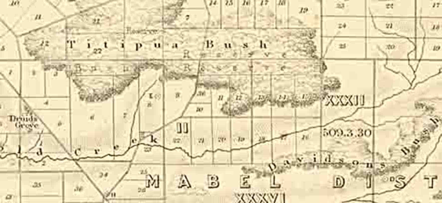
I can’t now locate that map that sat in front of me for two years in room 613 (Men’s tower) at Unicol. It’s around somewhere, no-doubt slotted between something else. But come the Internet Age and digital copies of these things tend to turn up out-there somewhere. I think it may have been the ‘Sketch Map of the Province of Southland’ compiled by the Chief Surveyor, John H. Baker, up to 1865. There is a digital copy of this map on the Auckland Council Libraries website (‘Sir George Grey Special Collections, Auckland Libraries, NZ Map 3817‘).

‘Sketch Map of the Province of Southland’ compiled by the Chief Surveyor, John H. Baker, up to 1865. There is from a digital copy of this map on the Auckland Council Libraries website (‘Sir George Grey Special Collections, Auckland Libraries, NZ Map 3817’). It shows patches of forest (blue-green) where almost none remain today.
While searching that web site, I found an even more detailed map (covering a slightly smaller area) – ‘Map of the southern portion of the Province of Southland’ also produced by J.H. Baker in 1865 (‘Sir George Grey Special Collections, Auckland Libraries, NZ Map 3816 and 3842‘).
This is a cadastral map – showing the surveyed boundaries of plots of land. It’s accuracy is amazing – using GIS techniques, it can be laid over the modern New Zealand 1:50,000 topographical maps almost exactly. At first glance, the surveyed small land plots seem to have been placed with total disregard for the forest, bisecting them everywhere. But only at first glance. A second look shows that it was the forest that was a major controlling factor. The plots were surveyed such that almost everyone (bar those in totally open areas) had about half their land in forest. This meant that everyone had a wood resource to use, and, of course, everyone could do their little bit to get rid of it. The orientation of roads and fence-lines that we see today, are ghosts, in a funny perpendicular sort of way, of those long-vanished patches of bush.

A section of an 1865 cadastral map showing forest/bush patches in the area around Invercargill (Sir George Grey Special Collections, Auckland Libraries, NZ Map 3842)
Southland’s patches of bush beg the question – why the patches? This patchwork is somehow unique. Why wasn’t it wall-to-wall forest, such as the vast Catlins area just to the east? It’s likely that fire had much to do with it. Before humans arrived in New Zealand, most of the land that was below the tree-line was probably covered in forest. With humans came fire, and the driest parts of the country, such as Central Otago, to the north of Southland, had their forests incinerated very quickly. It makes some intuitive sense that nor-wester gales would have driven fires from this broadly flammable interior region to the wetter southern areas, where there were more subtle controls on what did and didn’t burn. The Southland Plains also have many outcrops of lignite, which are known to have smoldered for many years, and may have provided repeated ignition pints. There are also lots of wetlands, swampy ground, and of course rivers, where forest would have only colonised with difficulty.
The question of ‘why the patches of bush in Southland’ is a good one for future academic research. But in fact, the whole landscape ecology is crying out for study. For example, the forest types are not controlled by volcanism, like much of the North Island, by slips and flooding braided rivers, like Westland, or by montane cold, like much of the rest. Southland’s forests show what grows without much of this extreme disturbance. There is now a growing public perception that these forests even existed, and an interest in understanding just what made them up. Paul Star’s article ‘Towards an environmental history of Seaward Forest’ is one such contribution. Star’s research stimulated an exhibition at the Eastern Southland Gallery, where 12 artists produced works on the topic. I didn’t see this, but I’d love to get a hold of the catalogue.

A section of an 1865 cadastral map showing forest/bush patches in the area around Waimatuku (Sir George Grey Special Collections, Auckland Libraries, NZ Map 3842).
Tramping in New Zealand has become virtually synonymous with negotiating high-country. That’s because that’s where our ‘wilderness’ and large areas of forest are left. We’ve whacked all the lowland stuff. For better or worse, this country now plays on its Middle Earth image. But it’s largely the dramatic. However, the subdued landscape with scattered patches of forest, also evoke a very Tolkinesque feeling. In fact, what could look more like some parts of Middle-Earth than that 1865 cadastral map – absent the cadastral lines of course? Imagine Southland’s tourism industry if more of that had survived? It would be a different kind of experience than completing a mountain trail, getting that sense of satisfaction at having lugged a huge pack from A to B (sometimes the same point) and taking the zillionth photograph of a scenic view. Instead, there could be something we don’t presently have much of in New Zealand, but is far more a European phenomenon – a network of lowland pathways. People could plot out a relaxing route, from bush to bush, stopping off at village cafes, or for Devonshire teas at enterprising farms. Even a small patch of bush, enough to shelter a picnic table, would be enough for some of Southland’s little ‘Bush’ settlements to re-establish their namesake.
The bushes have mostly gone, but from the point of view of a walker or cyclist, it may not take that much effort to reconstruct the feeling of being in them. Southland has a huge network of sometimes rather wide ‘long paddocks’ (the strip of land between the road and farm. It also has the rivers, and at least technically, public access along them (in reality this is more complicated, as in Southland, the rivers have often meandered away from the surveyed public land). The planting of native trees on these, and in fact, all over New Zealand, is an accelerating phenomenon. For the feeling of a trail through a forest, these only have to be wide enough to cut out the view of the road, and muffle the sound of traffic. It would be a kind of ‘geoengineering’. But, with a bit of political will and some long-term thinking, I think wonders could be worked.
What strikes me most about that 1865 map, is not just the huge areas of forest that have totally vanished, but that there are a few tiny patches of bush, perhaps just a hectare and peripheral to a huge forest, that are still there. Thanks to the vision of a few generations of some Southland farmers, these tiny remnants remain. There are shades (pun unintended) here of Geoff Park’s book ‘Nga Uru Ora’ (a weird coincidence: a friend and I had just completed 10 days walking around Stewart Island. We were relaxing at a picnic table back near Half Moon Bay, discussing Nga Uru Ora, when Park’s son literally walked out of the bush beside us). So it’s something I’ve wanted to do for ages – now that I can see exactly where those patches of bush were, I want to go and have a look. I want to see what remains, get a feel for what vanished, and what might be done… I’ll get back with future blog-posts.
Looking back, I suspect that ‘Derek the Dicot’ who framed one side of that map, was probably a monocot. But like my copy of that map, he seems to have vanished.
4 comments
Fascinating as usual Mike.
I thoroughly enjoy reading your posts.
The loss of so much of New Zealand’s lowland forest is truly lamentable.
I believe we would have a more aesthetically pleasing country if some of the land currently used for dairying were to be replanted with natives.
Southland is the only part of New Zealand I haven’t visited. I would love to explore the Catlins and maybe even look for fossils there.
I tried to find somewhere to aquire Nga Uru Ora online, but it looks like it may be hard to track down a copy. Amazon and Fishpond certainly don’t have it.
I look forward to your next post.
Regards,
Chris.
Thanks Chris,
I’ve been wanting to write something about those forests for ages – now just need to get down there and check some out close-up.
In the 1980s the attitude was all that “natives grow too slowly” , so they tended not to be planted by councils and so-on. Then there was a revolution, and new patches of native bush are springing up all over the place. It’ heartening. Even the huge swing towards dairy has an upside – they are required to prevent stock and effluent reaching drainages, so these are getting planted too.
I’m surprised Nga Uru Ora is hard to find, but as a consolation until a copy turns up – there are some podcasts Park made about various chapters of the book. I accessed them way-back through the podcast app on my iPad.
The Catlins is well worth a look!
Cheers
Mike
I grew up at Otaitai Bush about three miles from Riverton. My father was given 123 acres of land with a rough patch in the middle which he set about clearing to get more productive land. Whilst following his plough we came across many huge fallen and chared Totara Tree trunks which we remove from the plought area and he set about sawing them to length and making fence posts out of. We did wonder how this all happened. At the south/west end of the area he was working on there were several oven sites.
My brother who was a teacher said that oneof his pupils from Gummies Bush, about five miles awy over the lower part of the Aparima River, gave him some Moa Bones.
I suspect that a lot of the fence posts over Central Otago were old totara logs as well. Before the new town was built there was a post and rail fence that followed the road out of Cromwell. Suspect it was totara as well.